
Dallenwil
| Dallenwil | |
|---|---|
 |
|
| State : |
|
| Canton : |
|
| District : | No district division |
| BFS no. : | 1503 |
| Postal code : | 6383 |
| Coordinates : | 672 571 / 198620 |
| Height : | 545 m above sea level M. |
| Height range : | 477–1953 m above sea level M. |
| Area : | 15.48 km² |
| Residents: | 1846 (December 31, 2018) |
| Population density : | 119 inhabitants per km² |
|
Proportion of foreigners : (residents without citizenship ) |
8.2% (December 31, 2,015) |
| Website: | www.dallenwil.ch |
 Dallenwil |
|
| Location of the municipality | |
  |
|

Dallenwil (in the highest Alemannic local dialect [ˈtɑɫæˌʋɪiɫ] ) is a political municipality in the Swiss canton of Nidwalden .
geography
Dallenwil is located on the eastern slope of the Stanserhorn between the left bank of the Engelberger Aa up to the Hohberg and the Arvigrat . The community includes the following hamlets and settlement areas: Städtli, Chapellendorf, Mühledorf, Vorder-, Hinter- and Ober-Dallenwil as well as Oberau. Wirzweli , Wiesenberg , Dürrenboden and Wissifluh are located on an area terrace at around 1200 m . In terms of area, Dallenwil is the fifth largest municipality in the canton of Nidwalden.
Only 4.6% of the entire municipal area is settlement area. A large part of the community area is covered by wood and forest with 38.0%. An even larger area of 53.7% is used for agriculture - often as the Alps. A mere 3.7% are unproductive areas (mostly mountains).
history
Dallenwil is first recorded in writing around 1200 as de Telliwilare . The Old High German personal name Tello may be in the fore link; the place name would mean "homestead of Tello". The etymological relationships are unclear in detail, including the 1408 first tangible change from Tel- to valley raises questions.
The area was settled much earlier. Prehistoric hunters presumably made their way from the nearby Drachenloch (Ennetmoos) on hunting expeditions to Dallenwil. The first settlers are likely to have been the Celts, the Romans and later the Alemanni. Different place and field names indicate these early settlements. The oldest document that is important for the community of Dallenwil can be found in the land register of the Muri monastery from the year 1065. The area "Egg" (Wiesenberg) is referred to as the property of the monastery. Since this is an alpine area, it can be assumed that the Dallenwil municipal area was already being used to a greater or lesser extent at this point in time. The name "Dallenwil" (Telliwilare) was first mentioned in a toboggan from Engelberg Abbey from around 1190 or a little later. The Uertekorporation , first mentioned in 1348 and still in existence today, is the first public corporation to undertake common tasks for the population.
Dallenwil has one of the oldest municipal coats of arms. This was completely forgotten until, in 1899, H. Angst published a letter from the Dalwil Society in 1522 in the Anzeiger für Schweizerische Altertumskunde . This showed as a coat of arms St. Lawrence with rust and palm branch. St. Laurentius has been the chapel patron in Dallenwil since 1473. In 1905 the coat of arms was included in the series of the council chamber and has been considered official ever since.
coat of arms
The blazon reads: "In gold St. Laurentius with silver from the black writing" Sanctus Laurentius M. " covered nimbus , clad in a red dalmatic and silver alb , in the right hand a green palm, in the left a black grate. " The rust refers to the martyrdom of St. Lawrence, who was tortured to death on a grate over hot coals. The green palm symbolizes the martyr's palm .
population
Population development
By 1920, numerous locals emigrated from Dallenwil due to a lack of jobs. Despite a high birth surplus, this led to a shrinking population during this period (1850–1920: −7.7%). There was strong growth in the interwar period (1920–1941: + 28.7%). After a decade of stagnation, the population continued to grow until today (1950–2009: + 106.4%). The reason for this was the improvement in public transport and, above all, the construction of the A2 . The community also became attractive for commuters due to its proximity to the Nidwalden capital, Stans, and the low building land prices.

Population development of Dallenwil since 1850 Source: Population censuses (1850–2000 Federal), Federal Statistical Office (2010 and 2015)
languages
The population speaks a highly Alemannic dialect. Nidwalden German is still widely spoken. Almost the entire population speaks German as the everyday language. In the last census in 2000, 95.8% said German, 1.4% Albanian and 0.7% Serbo-Croatian as their main language.
Religions - denominations
The population used to be fully members of the Roman Catholic Church. The denominational relationships in 2000 still show the original structure despite the mixture. 1414 people were Catholic (85.75%). There were also 6.91% Protestant and 1.15% Orthodox Christians, 0.36% Muslims and 3.03% non-denominational. 43 people (2.61%) did not provide any information about their creed.
Origin - nationality
At the end of 2017, 1,669 (92.01%) of the residents were Swiss nationals. The majority of the immigrants come from Central Europe (Germany 49 people), Southern Europe (Portugal 22 and Italy 16 people) and the former Yugoslavia (Kosovo 22, Serbia 7 and Macedonia 5 people). At the 2000 census, 1,559 people (94.54%) were Swiss citizens; 46 of them had dual citizenship.
age structure
The church has a high proportion of middle-aged people. While the proportion of people under the age of twenty makes up 21.66% of the local population, 22.16% are senior citizens (60 years and older). The largest age group is now between 45 and 59 years. In 2000 it was still in the 30 to 44 age group. The reason for this is the aging of the baby boomer generation (born up to 1965). For every 100 people of working age (20–64 years; 1137 people) there are 35 young people (393 people) and 25 people (284 people) of retirement age.
The current age distribution is shown in the following table:
| Age | 0–6 years | 7-15 years | 16-19 years | 20-29 years | 30–44 years | 45–59 years | 60–79 years | 80 years and more | Residents | ||
| number | 117 | 175 | 101 | 244 | 313 | 462 | 337 | 65 | 1814 | ||
| proportion of | 6.44% | 9.65% | 5.57% | 13.45% | 17.25% | 25.47% | 18.58% | 3.58% | 100% | ||
| Source: Federal Statistical Office, population by age at the end of 2017 | |||||||||||
The aging increases. A comparison with the year 2000 proves this. The last census in 2000 showed the following age structure:
| Age | 0–6 years | 7-15 years | 16-19 years | 20-29 years | 30–44 years | 45–59 years | 60–79 years | 80 years and more | Residents |
| number | 173 | 259 | 87 | 168 | 450 | 271 | 210 | 31 | 1649 |
| proportion of | 10.49% | 15.71% | 5.28% | 10.19% | 27.29% | 16.43% | 12.73% | 1.88% | 100% |
economy
Agriculture originally dominated in Dallenwil. In Dallenwil there are smaller industrial companies (cable car construction, construction company) as well as commercial and service companies (Raiffeisen bank, printing company). There are still 46 farms and alpine farms in the Dürrenboden area.
In Dallenwil there were (2005) 555 employees in 120 companies. 26.1% of the employees in Dallenwil worked in agriculture / forestry / fishing (sector 1), 29.7% in industry and trade (sector 2) and 44.1% in service companies (sector 3). The unemployment rate in 2007 was 0.92%.
In 2017, 486 of the 776 employees were male and 290 female. The numbers for the 3 sectors are as follows:
| Companies 1st sector |
Employees 1st sector |
Full-time positions 1st sector |
Companies 2nd sector |
Employees 2nd sector |
Full-time positions 2nd sector |
Companies 3rd sector |
Employees 3rd sector |
Full-time positions 3rd sector |
Operations total |
employees Total |
Total full-time positions |
|
| number | 39 | 116 | 74 | 24 | 250 | 224 | 101 | 410 | 279 | 164 | 776 | 577 |
| proportion of | 23.78% | 14.95% | 12.82% | 14.63% | 32.22% | 38.82% | 61.59% | 52.84% | 48.35% | 100% | 100% | 100% |
| Source: Federal Statistical Office; Statistics of the company structure STATENT, workplaces and employees by municipality and economic sector | ||||||||||||
In 2000 there were 499 employees in Dallenwil. Of these, 295 (59.12%) were locals and 204 commuters. Most of the commuters came from the region; namely from Wolfenschiessen (18.6%), Oberdorf (13.7%), Stans (12.7%), Ennetbürgen (8.8%), Beckenried (7.8%), Stansstad (6.9%) and Buochs (6.4%). In the same year, 866 people from Dallenwil were gainfully employed. Thus 571 people worked in other communities. 182 people (= 31.9% of all commuters) commuted to the capital of Nidwalden, Stans, 71 people (12.4%) to Lucerne, 43 people (7.5%) to Oberdorf, 30 people (5.3%) to Engelberg %) and after Hergiswil 24 people (4.2%). Thus a relative majority of around 40% of the people commuted within the agglomeration of Stans, a strong minority in the agglomeration of Lucerne (city of Lucerne, Hergiswil etc.) and a smaller minority in the canton of Obwalden (Engelberg and the agglomeration of Sarnen).
traffic
The community of Dallenwil is located on the Luzern – Stans – Engelberg railway line of the Zentralbahn ; the station is the end of line S 4 of the Lucerne S-Bahn . In addition, the A2 motorway can be reached in a few minutes. The Dallenwil – Wirzweli and Dallenwil – Wiesenberg cable cars open up the Wiesenberg / Wirzweli area on the western side of the valley with 150 holiday homes as a skiing, recreation and hiking area. On the eastern side of the valley, the Dallenwil – Niederrickenbach cable car leads to the car- free pilgrimage site of Maria-Rickenbach (municipality of Oberdorf) and the catchment area of the Brisen .
Attractions
In addition to the baroque parish church of St. Laurentius, the Wiesenberg pilgrimage church is one of the parish's attractions. A geo-trail with 19 information boards on flora and geology leads from Stanserhorn to Wirzweli in 4 hours.
Personalities
- Jakob Joseph Matthys (1802–1866), priest, linguist and dialectologist
- Melchior Joller (1818–1865), publicist and politician
- Verena Bürgi (1949–2013), politician (CVP)
- The yodelling club Wiesenberg was able to place itself twice in the top 10 of the Swiss hit parade and achieved national recognition , especially with the song Ewigi Liäbi .
photos
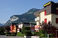
Dallenwil

Chapel of St. Catherine

Hist. Gasthaus Kreuz

Parish Church of St. Laurentius
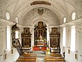
Parish Church of St. Laurentius

Wirzweli (excursion destination)


Web links
- Official website of the municipality of Dallenwil
- Peter Steiner: Dallenwil. In: Historical Lexicon of Switzerland .
Individual evidence
- ↑ Permanent and non-permanent resident population by year, canton, district, municipality, population type and gender (permanent resident population). In: bfs. admin.ch . Federal Statistical Office (FSO), August 31, 2019, accessed on December 22, 2019 .
- ↑ https://secure.i-web.ch/dweb/nw/de/onlinemain/publikationen/?pubid=8254&action=info ( page no longer available , search in web archives ) Info: The link was automatically marked as defective. Please check the link according to the instructions and then remove this notice.
- ↑ a b Albert Hug, Viktor Weibel: Nidwalden place and field names. Stans 2003. Volume III, columns 2436-2440.
- ^ Coat of arms of Dallenwil , information page on the municipality's website, accessed on March 11, 2013
- ↑ fahrplanfelder.ch: PDF , accessed on September 3, 2011
- ↑ fahrplanfelder.ch: PDF , accessed on October 20, 2010
- ^ Nidwalden District Administrator Verena Bürgi dies after a traffic accident. In: Neue Zürcher Zeitung from February 15, 2013
Beckenried | Buochs | Dallenwil | Emmetten | Ennetbürgen | Ennetmoos | Hergiswil | Oberdorf | Stans | Stansstad | Wolf shooting
Former municipality: Büren
Canton of Nidwalden | Districts | Municipalities in the canton of Nidwalden