Stanserhorn
| Stanserhorn | ||
|---|---|---|
|
View from the south-west of the Stanserhorn |
||
| height | 1897 m above sea level M. | |
| location |
|
|
| Mountains | Uri Alps | |
| Dominance | 4.26 km → Arvigrat | |
| Notch height | 500 m ↓ Ächerli | |
| Coordinates | 668 664 / 198 019 | |
|
|
||
| Development | 1893 Stanserhorn Railway | |
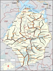
The Stanserhorn ( 1897 m above sea level ) is a mountain in the Swiss canton of Nidwalden , the local mountain of Stans and is located in the Uri Alps on the border with the canton of Obwalden .
geography
The Stanserhorn is located between the villages of Stans, Ennetmoos , Kerns , Dallenwil and Oberdorf , south of Lake Lucerne and thus (according to SOIUSA ) in the Unterwaldner Voralpen . On the southeast flank of the Stanserhorn lies at an altitude of 1226 m above sea level. M. the small resort of Wirzweli .
The panoramic view extends from the nearby Alpine peaks to the Vosges in Alsace (France) and the Feldberg in the Black Forest (Germany). In between, ten larger lakes can be made out: Zugersee , Wichelsee , Vierwaldstättersee , Sempachersee , Sarnersee , Hallwilersee , Gerzensee , Bannalpsee , Baldeggersee and Alpnachersee .
Development
The two mountain railway pioneers Franz Josef Bucher- Durrer and Josef Durrer- Gasser started construction of the Stanserhorn-Bahn in June 1891 , which due to the long route of almost 4 km in three separate funicular sections from Stans via Kälti and Alp Blumatt to the summit led. The lift opened on August 23, 1893, at the same time as the newly built Hotel Stanserhorn Kulm . In 1895 an electric spotlight with the «power of 22,000 normal candles» was installed on the summit to draw attention to the Stanserhorn as an attraction. A short circuit in the Blumatt station caused a fire on October 2, 1970, which destroyed the drive of the 3rd section, the hotel and the headlights. Instead of the hotel, a restaurant has been operating on the summit since then.
After the funicular railway had ceased operations in 1974, the Kälti – Stanserhorn aerial cableway was opened in 1975 , which now opened up the mountain together with the original 1st section. Since 2012 it has been possible to travel to the Stanserhorn with the double-decker «CabriO-Bahn», which is unique in the world. The open upper deck of the cable car cabin can be reached via a spiral staircase during the journey; the cabin can accommodate 60 people, the upper deck 30 of them.
The revolving restaurant Rondorama was opened as a tourist attraction in 2001 . From the rotating platform inside the building you have a panoramic view of the surrounding mountains and lakes. A marmot enclosure and a signposted summit tour of around 30 minutes complete the offer on the Stanserhorn, which is also marketed as a 5-star mountain and a lazy mountain . On the route from Stanserhorn to Wirzweli there is the Geo-Weg (mountain hike with difficulty level T2 according to the SAC hiking scale ), which was realized jointly by the organizations Nidwalden hiking trails, Pro Natura and WWF Unterwalden.
The Stanserhorn is used by hang gliders and paraglider pilots , it is considered the local mountain of the largest and oldest still active hang gliding club in Switzerland, the Stans Delta Club . On sunny days - especially on the weekends - there are many starts at lunchtime from April to October.
literature
- Christoph Berger: The little book from the Stanserhorn. Odermatt, Dallenwil 2005, ISBN 3-907164-12-1 .
Web links
- Website of the Stanserhorn Railway
- Geo-Weg Stanserhorn-Wirzweli on wirzweli.ch
Individual evidence
- ↑ a b Maps of Switzerland (SwissTopo) ( Page no longer available , search in web archives ) Info: The link was automatically marked as defective. Please check the link according to the instructions and then remove this notice.
- ↑ a b c Ernst Höhne: Knaur's Lexicon for Mountain Friends / The Alps between Matterhorn and Lake Constance . Droemer Knaur, Munich 1987, ISBN 3-426-26223-1 , p. 264 .
- ↑ A “new wind” in ropeway technology
- ↑ Club story on the website of the Delta Club Stans, accessed on October 25, 2016
- ↑ Stanserhorn flight area on the Stans Delta Club website, accessed on October 25, 2016


