
Kerns
| Kerns | |
|---|---|
 |
|
| State : |
|
| Canton : |
|
| District : | No district division |
| BFS no. : | 1404 |
| Postal code : | 6064 Kerns 6066 St. Niklausen 6067 Melchtal 6068 Melchsee-Frutt |
| UN / LOCODE : | CH KER |
| Coordinates : | 663 831 / 194 969 |
| Height : | 564 m above sea level M. |
| Height range : | 481–2700 m above sea level M. |
| Area : | 92.58 km² |
| Residents: | 6337 (December 31, 2018) |
| Population density : | 68 inhabitants per km² |
|
Proportion of foreigners : (residents without citizenship ) |
10.3% (December 31, 2,015) |
| Website: | www.kerns.ch |
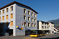
 Dorfstrasse in Kerns |
|
| Location of the municipality | |
  |
|
Kerns is a municipality in the canton of Obwalden in Switzerland . It is located near the main town of Sarnen and consists of the local village , Dietried , Hold , Melchtal , Siebeneich , St.Niklausen and sand / Wisserlen . The summer and winter sports resort of Melchsee-Frutt also belongs to Kerns .
geography

The village is 565 m above sea level. M. , the highest mountain is the Rotsandnollen (2700 m). With an area of 9,254 ha, the municipality of Kerns is the largest of the seven municipalities in the canton of Obwalden. In terms of area, Kerns ranks 52nd among the municipalities throughout Switzerland. The lakes Melchsee , Tannensee , Blausee and in the core forest are the very small lakes Gerzensee and Blindseeli. The community also borders the Wichelsee . The western boundary of the municipality is essentially formed by the course of the Great Melchaa .
Only 2.5% of the entire municipal area is settlement area. A large part of the community area is covered by wood and forest with a 28.8% share. Almost half of the municipal area, exactly 46.7%, is used for agriculture - often as the Alps. 21.9% are unproductive areas, mostly mountains and lakes.
Neighboring communities
The community core bordered to the north Ennetmoos ( NW ), northeast of Dallenwil ( NW ), to the east by Wolfenschiessen ( NW ), in the southeast on Innertkirchen ( BE ), to the south Hasliberg ( BE ), on the southwest by lounging in West on Sachseln , in the north-west on Sarnen and in the north-north-west on Alpnach .
population
Population development
The number of inhabitants in the municipality grew sharply between 1758 and 1850 (1758-1850: + 48.0%). The reason for this was a large excess of births. In 1850 and 1910 the population was almost the same (1850–1910: +1.2%). In between, it was even below these numbers, despite a clear birth surplus. The reasons for this were a strong emigration to the industrial regions of Switzerland and emigration overseas. For 100 years (since 1910) the number of residents has been increasing year after year. In the 50 years between 1910 and 1960 by 1,013 people or 39.9%, in the last 50 years (since 1960) by 2,047 people (1960–2010: +57.6%).
The reasons for the increase were the improvement in public transport and, above all, the construction of the A8 . This led to the establishment and settlement of numerous companies. The community also became attractive for commuters due to its proximity to the Obwalden capital Sarnen.
|
||||||||||||||||||||||||||||||||||||||||||||||

|


languages
Almost the entire population speaks Obwalden German, a high Alemannic dialect in Swiss German. At the last census in 2000, 96.15% stated German, 1.33% Albanian and 0.47% Portuguese as their main language.
Religions - denominations
The population used to be fully members of the Roman Catholic Church. The denominational relationships in 2000 still show the original structure despite the mixture. 4,422 people were Catholic (86.69%). There were also 4.72% Protestant and 0.49% Orthodox Christians, 2.18% Muslims and 2.55% non-denominational. 147 people (2.88%) did not provide any information on their creed. Until a few decades ago, almost the entire population was Catholic. The secularization of the church and the strong immigration from other parishes and abroad has led to a rapid rise in other confessional groups in Kerns.
Origin - nationality
Of the 6,337 residents, 5,677 (89.58%) were Swiss citizens at the end of 2018. The majority of the immigrants come from Central Europe (Germany 206, Hungary 22, Austria 16 and Poland 10 people), Southern Europe (Portugal 82, Italy 23 and Spain 9 people), the former Yugoslavia (North Macedonia 38, Kosova 31 and Serbia 22 people), Africa (Eritrea 31 people), Asia (Sri Lanka 45, Afghanistan 12 and China 9 people) and Turkey (10 people). At the 2000 census, 4,762 people (93.35%) were Swiss citizens; 84 of them had dual citizenship.
age structure
The church had a high proportion of middle-aged people in 2000. While the proportion of people under the age of twenty makes up 26.90% of the local population, 17.29% are senior citizens (60 years and older). The largest age group is made up of people between 30 and 44 years of age.
The last census in 2000 showed the following age structure:
| Age | 0–6 years | 7-15 years | 16-19 years | 20-29 years | 30–44 years | 45–59 years | 60–79 years | 80 years and more |
| number | 424 | 656 | 292 | 726 | 1258 | 863 | 684 | 198 |
| proportion of | 8.31% | 12.86% | 5.72% | 14.23% | 24.66% | 16.92% | 13.41% | 3.88% |
The community now has a high proportion of middle-aged residents. While the proportion of people under the age of twenty makes up 23.26% of the local population, 21.86% are senior citizens (60 years and older). The largest age group are people between 45 and 59 years. For every 100 people of working age (20–64 years; 3859 people) there are 38 young people (1474 people) and 26 people (1004 people) of retirement age.
The following age structure emerged at the end of 2018:
| Age | 0–6 years | 7-15 years | 16-19 years | 20-29 years | 30–44 years | 45–59 years | 60–79 years | 80 years and more | |||
| number | 525 | 662 | 287 | 775 | 1325 | 1378 | 1119 | 266 | |||
| proportion of | 8.28% | 10.45% | 4.53% | 12.23% | 20.91% | 21.75% | 17.66% | 4.20% | |||
| Source: Federal Statistical Office, population by age at the end of 2018 | |||||||||||
economy
Agriculture with cattle and horse breeding dominated originally. The extraction of iron, lime and gypsum began between the 15th and 18th centuries. Home work was added in the 19th century. This work disappeared again in the course of the same century. From 1907, more and more factory and service companies were added. The largest employers today are a pasta factory and companies in the metal and electronics industry.
In Kerns there were (2008) 1,993 employees in 384 companies. 20.4% of the employees in Kerns worked in agriculture / forestry / fishing (sector 1), 35.2% in industry and trade (sector 2) and 44.4% in service companies (sector 3). The unemployment rate in 2011 was 0.61%.
In 2017, 1470 of the 2542 employees were male and 1072 female. The numbers for the 3 sectors are as follows:
| Companies 1st sector |
Employees 1st sector |
Full-time positions 1st sector |
Companies 2nd sector |
Employees 2nd sector |
Full-time positions 2nd sector |
Companies 3rd sector |
Employees 3rd sector |
Full-time positions 3rd sector |
Operations total |
employees Total |
Total full-time positions |
|
| number | 146 | 392 | 240 | 86 | 788 | 670 | 267 | 1362 | 943 | 499 | 2542 | 1853 |
| proportion of | 29.26% | 15.42% | 12.95% | 17.23% | 31.00% | 36.16% | 53.51% | 53.58% | 50.89% | 100% | 100% | 100% |
| Source: Federal Statistical Office; Statistics of the company structure STATENT, workplaces and employees by municipality and economic sector | ||||||||||||
In 2000 there were 1,662 people in employment in Kerns. Of these, 1,197 (72.02%) were locals and 465 were commuters. Most of the commuters came from the region; namely from Sarnen (17.4%), Sachseln (11.2%), Alpnach (7.5%), Giswil (5.8%), Ennetmoos and Stans (3.9% each) and Lungern (3.4 %). In the same year, 2,741 people from Kerns were gainfully employed. Thus 1'544 people worked in other communities. 630 people (40.8% of all commuters) commuted to the Obwalden main town of Sarnen, 164 people to Lucerne (10.6%), 163 people to Sachseln (10.6%), 102 people to Stans (6.6%) ), 72 people to Alpnach (4.7%), 57 people to Kriens (3.7%), 44 people to Emmen (2.8%), 27 people to Hergiswil (1.7%) and 23 people to Giswil (1.5%).
traffic
Kerns the Sarnerstrasse leads down to Sarnen and the junction Sarnen north of the A8 motorway . The Stanserstrasse (Kantonsstrasse) goes through the core forest via Ennetmoos to Stans . The Melchtalerstrasse leads into Melchtal via St. Niklausen, Melchtal to Stöckalp, from where Melchsee-Frutt can be reached by gondola lift and in summer via a single-lane road . The Kägiswilerstrasse leads from Kerns to Kägiswil and the Flüelistrasse over the Hohe Brücke to Flüeli-Ranft . From the district of Wisserlen (and also from the center via Unterhalten) a narrow road leads over the Ächerli pass to Dallenwil in the Engelbergertal .
The municipality of Kerns is connected to the public transport network through the postbus courses Sarnen (train station) - Kerns - Stans (train station) and Stans (train station) - St.Jakob - Kerns - Sarnen (train station). The Sarnen (train station) - Melchtal - Stöckalp post bus line also provides tourist access. In addition, postbuses drive from Sarnen via Kerns to Flüeli-Ranft in the evening.
gallery

Kerns

Parish Church of St.Gallus
Sarnerstrasse with post

Dossenhalle

Schoolhouse Sidern

Stanserstrasse


Town twinning
Culture and sights
- Chapel of St. Katharina in Wisserlen: At the gallows west of the chapel, common rural communities and conferences of the Unterwaldners (Obwalden and Nidwalden) occasionally took place until the end of the 17th century . The gallows was part of the old "unity" of the rural community as a judicial community.
- The Kernser Singbuben are a boys' choir founded in 1949 with a predominantly folkloric repertoire and an international reputation.
Personalities
Sons and daughters of the place
- Franz Abart (1769–1863), originally a sculptor from South Tyrol
- Joseph Ignaz von Ah (1834-1896), pastor in Kerns 1867-1896
- Franz Josef Bucher (1834–1906), hotelier, railway pioneer and entrepreneur
- Josef Durrer (1841–1919), engineer, hotel pioneer and entrepreneur
- Zeno Durrer (1884–1967), entrepreneur
- Josef Amstutz (1927–1999), Catholic theologian
- Beda Durrer (1933–1993), painter and bizarre inventor
- Niklaus von Flüe (1934–2013), historian, author and teacher
- Ivan Bucher (* 1973), bodybuilder
Honorary citizen
Honorary citizens of Kerns include the painter Emil Schill (1870–1958), who lived and worked in Kerns from 1911 to 1958, the politician Otto Hess (1873–1962) and the marathon runner Viktor Röthlin from Kerns .
literature
- Rupert Amschwand: Kerns. Kerns parish, 1976.
- Karl Imfeld : Parish history of Kerns: 10th century to 2010. Verlag Martin Wallimann, Alpnach 2012, ISBN 978-3-905969-13-9 .
Web links
- Official website of the municipality of Kerns
- Willi Studach: Kerns. In: Historical Lexicon of Switzerland .
Individual evidence
- ↑ Permanent and non-permanent resident population by year, canton, district, municipality, population type and gender (permanent resident population). In: bfs. admin.ch . Federal Statistical Office (FSO), August 31, 2019, accessed on December 22, 2019 .
- ↑ http://www.statistik-obwalden.ch/index.cfm?navid=83&docid=83
- ↑ fahrplanfelder.ch: 60.341.pdf (application / pdf-Objekt; 140 kB) , accessed on November 20, 2010
- ↑ fahrplanfelder.ch: 60.312.pdf (application / pdf-Objekt; 98 kB) , accessed on November 20, 2010
- ↑ fahrplanfelder.ch: 60.343.pdf (application / pdf-Objekt; 113 kB) , accessed on November 20, 2010
- ↑ Cultural assets in the Kerns community (PDF) , Kerns Culture Commission, 2018, accessed on June 20, 2019
- ↑ website of Kernser Sing boys
- ^ Tapan Bhattacharya: Abart, Franz. In: Historisches Lexikon der Schweiz .
- ^ Romano Cuonz , Hanspeter Niederberger : hotel king, manufacturer: Franz Josef Bucher - mountain railway builder, inventor: Josef Durrer - painter, dreamer: Beda Durrer. Brunner, Kriens 1998, ISBN 3-905198-45-2
- ^ Artists in Kerns on the Kerns municipality website, accessed on May 7, 2016