Red sand bulbs
| Red sand bulbs | ||
|---|---|---|
|
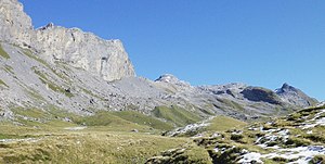
View of the Rotsandnollen (center) from the south, the Barglen on the left, the Schwarzhorn on the right |
||
| height | 2700 m above sea level M. | |
| location | Canton border Nidwalden / Obwalden , Switzerland | |
| Mountains | Unterwaldner Voralpen | |
| Dominance | 4.72 km → Mären | |
| Notch height | 493 m ↓ Jochpass | |
| Coordinates | 669 105 / 183664 | |
|
|
||
The Rotsandnollen is a 2700 meter high mountain between the Melchtal and Engelbergertal in Switzerland .
location
The summit of the Rotsandnollens lies on the canton border between Nidwalden and Obwalden . It belongs to the Unterwaldner Voralpen and thus to the Lucerne and Unterwaldner Voralpen (subsection 14.III of the SOIUSA classification).
It is the highest elevation in the municipality of Kerns , the highest mountain on the flanks of the Saarneraatal and after the mountains in the Engelberg exclave ( Titlis with 3238 m, Reissend Nollen with 3002 m, Grassen (2946 m) with subsequent Grassengrat, Wissigstock with 2887 m and Engelberger Rotstock with 2818 m) the highest point in Obwalden.
Neighboring peaks are in the north the Huetstock with 2676 m (in between the somewhat higher, but less known Hanghorn with 2679 m), in the southwest the Barglen (Schiben), behind it the Hohmad, and in the southeast the Schwarzhorn and the Graustock .
The summit is marked with a stone pyramid.
Ascent
The red sand nollen can be climbed on trackless but relatively easy terrain over the saddle between Barglen and red sand nollen. The tour is classified as T2-3 or B (mountain hikers) on the SAC hiking scale . The saddle can also be reached via unpaved terrain. Either from the Stöckalp in the valley via Unter Boden and the Wolfisalp or from the Bonistock in the Melchsee-Frutt resort . A Schrattenkalk karst field with barren weathered surfaces is crossed to the south of the Rotsandnollens .
In winter, the Rotsandnollen is a worthwhile destination for both snowshoe hikers and ski tourers.
Web links
- Red sand nollen - 360 ° panorama with maximum visibility Sketch and directory of the mountains visible from the red sand nollen
- Tour report of red sand nollen from the Freiburg Police Sports Club with lots of photos
- Collection of tour reports on red sand nollen on hikr.org
Individual evidence
- ↑ Entry in the SAC Guide to Central Switzerland Prealps (1996)


