
Innertkirchen
| Innertkirchen | |
|---|---|
 |
|
| State : |
|
| Canton : |
|
| Administrative district : | Interlaken-Oberhasli |
| BFS no. : | 0784 |
| Postal code : | 3862 Innertkirchen 3863 Gadmen |
| Coordinates : | 660 441 / 173058 |
| Height : | 625 m above sea level M. |
| Height range : | 609–3702 m above sea level M. |
| Area : | 236.59 km² |
| Residents: | 1063 (December 31, 2018) |
| Population density : | 4 inhabitants per km² |
| Website: | www.innertkirchen.ch |
 Innertkirchen |
|
| Location of the municipality | |
  |
|
Innertkirchen is a municipality in the Interlaken-Oberhasli administrative district in the canton of Bern in Switzerland .
geography

The village is located in the Haslital in the Bernese Oberland , six kilometers southeast of Meiringen , separated from it by the Aare Gorge and is an important traffic junction. The Aare flows through the municipality and begins in the neighboring municipality of Guttannen to the south . Innertkirchen is the starting point for the Trift Glacier (Gadmen) near Gadmen and Rosenlauigletscher via Meiringen or via the mountain path to the Dossenhütte . Innertkirchen also includes the Gental , at the end of which is the Engstlenalp with the Engstlensee .
From Innertkirchen the road also leads to Understock and into the Urbachtal , from where you can continue to the Gauligletscher , the Dossenhütte and the Engelhornhütte.
economy
The lowest stage of the Grimsel hydropower plant operated by Kraftwerke Oberhasli AG (KWO for short) is located in Innertkirchen .
traffic
From Innertkirchen you can get over the Grimsel Pass to Gletsch in the canton of Valais and over the Susten pass to Wassen in the canton of Uri. Innertkirchen is known for tourism in addition to these two passes through the Aare Gorge . Innertkirchen is the end point of the Meiringen-Innertkirchen railway .
tourism
In Innertkirchen there are five hotels with 196 beds, a bed and breakfast with 20 beds, 26 holiday apartments with 147 beds and four group accommodations with 194 beds. There are also four tent sites that are used by families, hikers and cyclists in summer. Innertkirchen has three restaurants (seasonal operations).
Nearby attractions are the Aare Gorge , the Urbachtal , the Reichenbach Falls , the Ballenberg open-air museum and the Hasliberg .
population
| Population development | ||||||||||||
|---|---|---|---|---|---|---|---|---|---|---|---|---|
| year | 1764 | 1850 | 1880 | 1900 | 1930 | 1950 | 1960 | 1970 | 1980 | 1990 | 2000 | 2012 |
| Residents | 656 | 1,375 | 1,438 | 1,105 | 1,074 | 1,194 | 1'230 | 1,064 | 966 | 998 | 936 | 915 |
Attractions
Impressions

Engstlenalp with hotel

Meiringen-Innertkirchen-Bahn railcars at the main intersection of Innertkirchen


Village center
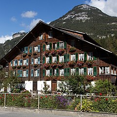
Haslital residential building
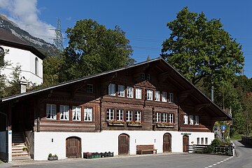
Typical house and kindergarten


literature
- Daniel Wolf, Jost von Allmen: Ernst E. Anderegg . Selected buildings in the Interlaken-Oberhasli region. (Swiss Art Guide, No. 887/888, series 89). Ed. Society for Swiss Art History GSK. Bern 2011, ISBN 978-3-85782-887-4 .
Web links
- Official website of the municipality of Innertkirchen
- Anne-Marie Dubler : Innertkirchen. In: Historical Lexicon of Switzerland .
Individual evidence
- ↑ Permanent resident population from STAT-TAB of the BfS , municipalities see also regional portraits 2020 on bfs.admin.ch, accessed on May 29, 2020
- ↑ Archive link ( Memento of the original from March 31, 2009 in the Internet Archive ) Info: The archive link was inserted automatically and has not yet been checked. Please check the original and archive link according to the instructions and then remove this notice.
Beatenberg | Bönigen | Brienz | Brienzwiler | Därligen | Grindelwald | Gsteigwiler | Gündlischwand | Guttannen | Habkern | Hasliberg | Hofstetten near Brienz | Innertkirchen | Interlaken | Iseltwald | Lauterbrunnen | Leissigen | Lütschental | Mats near Interlaken | Meiringen | Niederried near Interlaken | Oberried am Brienzersee | Ringgenberg | Saxeten | Shadow half | Schwanden near Brienz | Unterseen | Wilderswil
Former parishes: Ebligen | Gadmen | Goldswil | Isenfluh
Canton of Bern | Administrative districts of the canton of Bern | Municipalities of the Canton of Bern