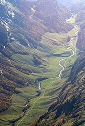
Gental
The Gental in the Swiss canton of Bern is a northern side valley of the Gadmer valley and thus also of the Haslital of the upper Aare . It is traversed by the Gentalwasser , which flows into the Gadmerwasser at Innermühletal , which reaches the Aare at Innertkirchen .
The upper end of the valley lies in the northeast and is connected to the Trüebsee in Engelbergertal by the Jochpass . At the upper end of the valley is the Engstlensee at 1850 m above sea level. M. and shortly before the Engstlenalp . On the north side, above the trough shoulder, lies the Alp Tannalp in the relatively flat Tannen high valley . The watershed to the Sarner Aa and thus to the Reuss runs right through this and then to the southwest over the rather rugged Ärzegg . Beyond the watershed are the Tannensee and the winter sports resort of Melchsee-Frutt .
The Gental is hardly populated and is therefore one of the most secluded places in the Central Swiss Alps . In the Second Villmerger War in 1712, Vaudois troops marched through the Gental up to Engstlenalp to protect the Bernese border, where they established themselves and where field service was held on two Sundays .
Transport links
The access to Gental is from Innertkirchen via Sustenstrasse . The road in Gental is a private road operated by the Mühletal-Engstlenalp cooperative and is chargeable for motor vehicles from the Wagenkehr restaurant. The Gental is a dead end , there is no through traffic.
From Meiringen via Innertkirchen, a post bus drives through the Gental to Engstlenalp.
Web links
Individual evidence
- ↑ Genthal. In: Geographical Lexicon of Switzerland . Second volume. Attinger, Neuenburg 1904, p. 290.
- ^ Website of the Mühletal-Engstlenalp road cooperative
- ↑ Engstlenalp route operated by PostBus Schweiz AG
Coordinates: 46 ° 44 ′ 29 " N , 8 ° 17 ′ 22" E ; CH1903: 665017 / 177031
