
Gental water
|
Gentalwasser Gäntelwasser |
||
 Gental with the Gental water, aerial view |
||
| Data | ||
| Water code | CH : 1884 | |
| location |
Uri Alps
|
|
| River system | Rhine | |
| Drain over | Gadmerwasser → Aare → Rhine → North Sea | |
| source | in Engstlensee 46 ° 46 ′ 7 ″ N , 8 ° 22 ′ 44 ″ E |
|
| Source height | approx. 2278 m above sea level M. | |
| muzzle | before Innertkirchen into Gadmerwasser Coordinates: 46 ° 42 ′ 50 " N , 8 ° 15 ′ 55" E ; CH1903: 663 196 / 173 971 46 ° 42 '50 " N , 8 ° 15' 55" O |
|
| Mouth height | 804 m above sea level M. | |
| Height difference | approx. 1474 m | |
| Bottom slope | approx. 11% | |
| length | 13.6 km | |
| Catchment area | 39.7 km² | |
| Discharge A Eo : 39.7 km² at the mouth |
MQ Mq |
2.48 m³ / s 62.5 l / (s km²) |
| Communities | Innertkirchen , Hasliberg | |
The Gentalwasser , in the Swiss national map Gäntalwasser , also Engstlenbach , is an approximately 14 kilometers long right tributary of the Gadmerwasser in the Swiss canton of Bern , which flows through the Gental in the Bernese Oberland .
geography
course
The wild river rises below the Joch glacier on the Wendenstock and initially flows through the Engstlensee , a natural reservoir near the border with the canton of Obwalden .
About 500 meters after the lake drainage, the water is collected and passed through a tunnel into the neighboring Gadmertal , where it is used by the Fuhren power station, which directs its underwater through a counterpressure tunnel into the shaft window of the Steinwasser – Trift intake tunnel. The water can then either be used in the Hopflauenen and Innertkirchen 2 power plants or pumped into the Räterichsboden reservoir via the pump turbine from Handeck 3 .
The Gentalwasser flows around 12 kilometers through the Gental and flows into the Gadmerwasser at the hamlet of Mühletal above Innertkirchen , which has covered approximately the same distance through the Gadmertal to this point .
Four kilometers later the Gadmerwasser flows into the Aare near Innertkirchen .
Catchment area
The 39.68 km² catchment area of the Gentalwasser lies in the Urner Alps and is drained through it over the Gadmerwasser, the Aare and the Rhine to the North Sea.
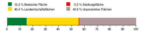
It consists of 15.3% wooded area , 40.4% agricultural area , 0.5% settlement area and 43.9% unproductive areas.
The area distribution
The mean height is 1959.7 m above sea level. M. , the minimum height is 833 m above sea level. M. and the maximum height at 3015 m above sea level. M.
Tributaries
- Gummbächli ( right ), 1.2 km, 0.97 km²
- (Belly from) Bockchänel ( left ), 0.3 km
- (Bach from the) Wunderbrunnen ( right ), 1.0 km, 1.4 km²
- Henglibach ( right ), 2.6 km, 5.21 km², 360 l / s
- Zylfluchtbach ( Tannenbach ) ( right ), 2.7 km, 2.09 km²
- Moosbach ( left ), 1.9 km
- Scharmadbach ( left ), 2.7 km, 3.36 km²
- Ufem Graben ( right ), 1.1 km
- Waschibächli ( right ), 1.4 km
- Sywbalmbächli ( left ), 1.0 km
- Jungibach ( left ), 0.3 km
- Jungibach 2 ( left ), 0.5 km
- Jungibach 1 ( left ), 0.2 km
- Lägerbächli ( right ), 1.3 km
- Am Cheeren ( right ), 1.1 km
- Indere Wüöstbach ( left ), 1.0 km
- Üsser Wüöstbach ( left ), 0.5 km
- Number ( left ), 1.3 km, 1.14 km²
- Hinderarnibach ( left ), 1.7 km, 0.76 km²
Hydrology
At the confluence of the Gental water in the Gadmer water, its modeled mean flow rate (MQ) is 2.48 m³ / s. Its discharge regime type is nivo glaciaire and its discharge variability is 17.

Web links
- Course of the Gental water on the Geoportal Bern
- Course of the Gental water on the geoserver of the Swiss Federal Administration ( information )
Individual evidence
- ↑ a b c d e Geoserver of the Swiss Federal Administration ( information )
- ↑ Water network. In: Geoportal of the Canton of Bern.
- ↑ a b The expansion of hydropower in the Gental and Gadmental with the Fuhren power station . In: Schweizerische Bauzeitung . tape 79 , no. 44 , November 2, 1961, pp. 755 , doi : 10.5169 / seals-65615 .
- ↑ Plant diagram of the KWO.
- ↑ Central sheets Fuhren (Gental) and Fuhren (pump center) . In: Statistics on hydropower plants in Switzerland. Federal Office of Energy, January 1, 2020 .
- ↑ Topographic catchment areas of Swiss waters: Gentalwasser , Federal Office for the Environment FOEN
- ↑ "Hidden behind the mean values" - the variability of the discharge regime , p. 7
- ↑ The discharge variability describes the extent of the fluctuations in the mean discharge of individual years around the long-term mean discharge value.
- ↑ Average discharge and discharge regime type for the Swiss water network: Steinwasser , Federal Office for the Environment FOEN