Uri Alps
| Uri Alps | |
|---|---|
|
Dam stick |
|
| Highest peak | Dammastock ( 3630 m above sea level ) |
| location | mostly canton Uri ( Switzerland ) |
| part of | Central Alps , Western Alps |
| Coordinates | 680000 / 175000 |
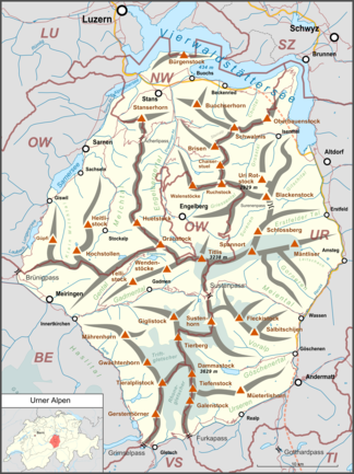
The Urner Alps are a mountain group in the Western Alps . They are located in Switzerland in the cantons of Uri , Wallis , Bern , Nidwalden and Obwalden . The large number of cantons involved may give the impression of a complicated mountain structure. On the contrary, the Uri Alps form a compact, easily demarcated mountain group between Lake Lucerne in the north, the Reuss Valley (Gotthard axis) in the east, the Furka Pass and Grimsel Pass in the south and the Brünig Pass in the west.
Division according to SOIUSA
According to SOIUSA , the Urner Alps are subsection 12.I and thus part of the Bernese Alps in the broader sense .
- After SOIUSA the Urner Alps end in the west at Haslital and already in Gental and not with the Brünigpass . The area between Gental and Brünig Pass and also the Melchsee-Frutt then falls into the Lucerne and Unterwaldner Pre-Alps .
- In the north, the border is the Griessental and the Isital and not just on Lake Lucerne . The more pre- alpine- like area then falls into the Lucerne and Unterwaldner pre-Alps
- in the east to the Urner-Glarus Alps (Osturner Alps) as part of the Glarus Alps in the broader sense bounded by the Reuss and Reuss Valley
- In the south the Furkapass , Garschen , Ursern and Furkareuss form the less controversial border to the Lepontine Alps with the Monte Leone-Sankt Gotthard-Alps subsection
According to SOIUSA , the Uri Alps are almost exclusively limited to the Canton of Uri .
structure
The group is characteristically divided into three subgroups:
- Dammastock group (in the narrower sense) in the south (Dammastock)
- Train of the Titlis in the center with foothills to the northwest ( Titlis 3238 m above sea level )
- Urirotstock group in the northeast ( Uri Rotstock 2928 m above sea level )
The demarcation is Gadmertal - Sustenpass - Meiental and Engelbergertal - Surenenpass .
From the Engelbergertal penetrating deep into the group comes the name Engelberg Alps for this mountain area.
summit
The highest peak is the Dammastock ( 3630 m ). The Uri Alps have numerous three-thousand-meter peaks and glaciers. Although not as famous as the neighboring Bernese Alps , the Uri Alps offer everything a mountaineer, high tourist and nature lover could wish for. One of the advantages of the Uri Alps are the high starting points, which allow the mountaineer to reach the high region quickly and which allow the tourist to enjoy magnificent high mountain images without much effort. These include some mountain railways in the north of the group, but above all the three passes Sustenpass in the middle of the group and Furkapass and Grimselpass on the edge of the group.
As with the neighboring mountain groups on the northern edge of the Alps, the Uri Alps are often affected by the west and north-west weather conditions. As a result, the weather in the Uri Alps is relatively unstable and less favorable than in the central and southern parts of the Alps.
Three thousand meter peaks
There are 57 named three-thousand-meter peaks in the Uri Alps. They are listed below in order of height:
|
|
|
Protected areas
Landscapes of national importance
In accordance with Article 5 of the Federal Act on Nature Conservation and Heritage Protection, Switzerland keeps a federal inventory of landscapes and natural monuments of national importance .
There are currently four of these landscapes in the Uri Alps.
- No. 1507, designation: Bernese High Alps and Aletsch-Bietschhorn area (northern part) , year of inclusion in the inventory: 1983, revision: 1996, size: 49,581 ha, only a small part of this area is in the Uri Alps.
- No. 1512, name: Aare gorge Innertkirchen-Meiringen , year of inclusion in the inventory: 1996, size: 80 ha
- No. 1606, name: Vierwaldstättersee with Kernwald, Bürgenstock and Rigi , year of inclusion in the inventory: 1983, size: 38,198 hectares, only part of this area is in the Uri Alps.
- No. 1710, designation: Rhone glacier with foreland , year of inclusion in the inventory: 1996, size: 3,703 ha
tourism
Long-distance / long-distance hiking trails
The Via Alpina , a cross-border long-distance hiking trail with five partial routes through the entire Alps, also runs through the Uri Alps.
The Via Alpina Green Trail runs in two stages through the Urner Alps as follows:
- Stage C7 runs from Altdorf in the Reuss Valley to Engelberg over the Surenen Pass
- Stage C8 runs from Engelberg to Meiringen over the Jochpass
literature
- Sergio Marazzi: Atlante Orografico delle Alpi. SOIUSA . Pavone Canavese (TO), Priuli & Verlucca editori, 2005. ISBN 978-88-8068-273-8 (Italian)
- Sergio Marazzi, La “Suddivisione orografica internazionale unificata del Sistema Alpino” (SOIUSA) - the complete article with detailed illustrations (pdf; 1.6 MB) (Italian)
Web links
Individual evidence
- ↑ The name Dammagruppe can also be found for the entire Urner Alps in the sense of SOIUSA, as in B. Studer: Geologie der Westen Schweizer-Alpen , 1834.

