| number
|
Surname
|
admission
|
Revisions
|
photo
|
| 1001 |
Left bank of Lake Biel
|
1977 |
|
|
| 1002 |
Chasseral |
1977 |
|

|
| 1003 |
Tourbière des Ponts-de-Martel
|
1977 |
|
|
| 1004 |
Creux du Van and Gorges de l'Areuse
|
1977 |
|

|
| 1005 |
Vallée de la Brévine |
1977 |
1983 |
|
| 1006 |
Vallée du Doubs |
1977 |
1998 |

|
| 1007 |
La Dole |
1977 |
1983 |

|
| 1008 |
Franches-Montagnes |
1977 |
1983 |

|
| 1009 |
Gorges du Pichoux |
1977 |
1996 |

|
| 1010 |
Weissenstein |
1977 |
|

|
| 1011 |
Warehouse area |
1977 |
|

|
| 1012 |
Belchen - Passwang area |
1983 |
1996 |

|
| 1013 |
Les Roches de Châtoillon |
1983 |
1998 |
|
| 1014 |
Chassagne |
1983 |
1998 |
|
| 1015 |
Pied sud du Jura proche de La Sarraz
|
1983 |
|
|
| 1016 |
Aarewaage Aarburg
|
1996 |
|

|
| 1017 |
Aargau and eastern Solothurn folded Jura
|
1996 |
|
|
| 1018 |
Aare gorge Brugg
|
1996 |
|

|
| 1019 |
Moated castle (confluence Aare / Reuss / Limmat ) |
1996 |
|

|
| 1020 |
Ravellenflue and Chluser Roggen near Oensingen
|
1996 |
|
|
| 1021 |
Gorges de Moutier |
1996 |
|

|
| 1022 |
Vallée de Joux and Haut-Jura vaudois |
1998 |
|

|
| 1023 |
Le Mormont |
1998 |
1983 |

|
| 1101 |
Etangs de Bonfol and de Vendlincourt
|
1977 |
|

|
| 1102 |
Beets |
1977 |
|
|
| 1103 |
Koblenzerlauf |
1977 |
|

|
| 1104 |
Table Jura north of Gelterkinden
|
1983 |
1996 |
|
| 1105 |
Baselbieter and Fricktaler Tafeljura
|
1983 |
1996 |
|
| 1106 |
Chill out at Diegten
|
1983 |
|
|
| 1107 |
Gempen Plateau |
1983 |
|

|
| 1108 |
Aargau Table Jura
|
1996 |
|

|
| 1109 |
Aare landscape near Klingnau
|
1996 |
|
|
| 1110 |
Wangen- and Osterfingertal
|
1996 |
1998 |

|
| 1201 |
La Cote |
1977 |
1998 |

|
| 1202 |
Lavaux |
1977 |
1998 |

|
| 1203 |
Greves vaudoises de la rive gauche du lac de Neuchâtel
|
1977 |
1996
|
| 1204 |
Le Rhône genevois-Vallons de l'Allondon et de La Laire |
1977 |
|

|
| 1205 |
Bois de Chênes |
1977 |
|
|
| 1206 |
Coteaux de Cortaillod et de Bevaix
|
1977 |
1998 |
|
| 1207 |
Marais de la Haute Versoix
|
1977 |
1998
|
| 1208 |
South shore of Lake Neuchâtel
|
1983 |
|
|
| 1209 |
Mont Vully |
1983 |
|
|
| 1210 |
Chanivaz - delta de l'Aubonne |
1996 |
|
|
| 1301 |
St. Petersinsel - Heidenweg
|
1977 |
1996 |

|
| 1302 |
Alte Aare / Alte Zihl
|
1977 |
|

|
| 1303 |
Hallwilersee |
1977 |
|

|
| 1304 |
Baldeggersee |
1977 |
|

|
| 1305 |
Reuss landscape |
1977 |
|
|
| 1306 |
Albiskette - Reppischtal
|
1983 |
|

|
| 1307 |
Glacial landscape between Lorzentobel and Sihl with chain of caves
|
1993 |
|

|
| 1308 |
Rothenthurm - Altmatt - Biberbrugg moorland
|
1983 |
|
|
| 1309 |
Lake Zug |
1983 |
|
|
| 1310 |
Lucerne Glacier Garden |
1983 |
|

|
| 1311 |
Napfbergland |
1983 |
1996 |
|
| 1312 |
Mats of water in the Langete , Rot and Önz valleys
|
1983 |
|

|
| 1313 |
Steinhof - Steinenberg - Burgäschisee
|
1983 |
|

|
| 1314 |
Aare landscape Thun - Bern
|
1983 |
|
| 1315 |
Amsoldinger and Uebeschisee
|
1983 |
|

|
| 1316 |
Niederried reservoir |
1983 |
|
|
| 1317 |
Terminal moraine zone of Staffelbach |
1996 |
|
|
| 1318 |
Wauwilermoos - Hagimoos - Mauensee
|
1996 |
|

|
| 1319 |
Aareknie Wolfwil - Wynau
|
1996 |
|
|
| 1320 |
Schwarzenburgerland with scythe and black water gorges
|
1996 |
|

|
| 1321 |
Emmental landscape with Räbloch , Schopfgraben and Rämisgummen
|
1996 |
|

|
| 1401 |
Drumlin landscape of the Zurich Oberland
|
1977 |
|
| 1402 |
Immenberg |
1977 |
1983
|
| 1403 |
Glacial landscape between the Thur and the Rhine with the Nussbaumer lakes and Andelfingen lakes
|
1977 |
|
| 1404 |
Glacial landscape Neerach - Stadel
|
1977 |
|
| 1405 |
Frauenwinkel - Ufenau - Lützelau
|
1977 |
1996 |

|
| 1406 |
Zurich Obersee |
1977 |
|

|
| 1407 |
Cat lakes |
1977 |
|

|
| 1408 |
Jörentobel |
1977 |
|

|
| 1409 |
Pfäffikersee |
1977 |
|
|
| 1410 |
Irchel |
1977 |
|

|
| 1411 |
Untersee - Upper Rhine
|
1983 |
|

|
| 1412 |
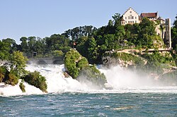
Rhine Falls |
1983 |
|
|
| 1413 |
Thurgauian - princely cultural landscape with Hudelmoos
|
1983 |
1996
|
| 1414 |
Thur landscape Lichtensteig - Schwarzenbach
|
1983 |
|
| 1415 |
Böllenbergtobel near Uznach
|
1983 |
|
| 1416 |
Kaltbrunner Riet |
1983 |
|
| 1417 |
Lützelsee - Seeweidsee - Uetziker Riet
|
1983 |
|
|
| 1418 |
Espi-Hölzli |
1983 |
|
| 1419 |
Pfluegstein whether Erlenbach
|
1983 |
|
| 1420 |
Hörnli-Bergland (headwaters of the Töss and Murg ) |
1996 |
|
| 1501 |
Apply - Iffigen
|
1977 |
1998
|
| 1502 |
Les Grangettes |
1977 |
1998
|
| 1503/1713 |
Diablerets - Vallon de Nant-Derborence (western part) |
1977 |
1996/98
|
| 1504 |
Vanil Noir |
1977 |
|

|
| 1505 |
Hohgant |
1977 |
|

|
| 1506 |
Chaltenbrunnenmoor - Wandelalp
|
1977 |
1996
|
| 1507/1706 |
Bernese High Alps and Aletsch-Bietschhorn area (northern part) |
1983 |
|
| 1508 |
Weissenau |
1983 |
|
| 1509 |
Luegibodenblock |
1983 |
1998 |

|
| 1510 |
La Pierreuse - Gummfluh - Vallée de l'Etivaz
|
1983 |
|
| 1511 |
Giessbach |
1996 |
|

|
| 1512 |
Aare Gorge Innertkirchen - Meiringen
|
1996 |
|
|
| 1513 |
Engstligenfalls with Engstligenalp
|
1996 |
|
|
| 1514 |
Brecca throat |
1996 |
|

|
| 1515 |
Tour d'Aï - Dent de Corjon
|
1998 |
|

|
| 1601 |
Silberen |
1977 |
|

|
| 1602 |
Murgtal - Mürtschental
|
1977 |
|
| 1603 |
Maderanertal - Fellital
|
1977 |
|
| 1604 |
Lauerzersee |
1977 |
|
| 1605 |
Pilate |
1977 |
|
| 1606 |
Vierwaldstättersee with Kernwald, Bürgenstock and Rigi
|
1983 |
|
| 1607 |
Goldau landslide area |
1983 |
|
| 1608 |
Flyschlandschaft Hagleren - Glaubenberg - Schlieren
|
1983 |
|
| 1609 |
Schrattenflue |
1983 |
|
| 1610 |
Scheidnössli near Erstfeld
|
1983 |
|
| 1611 |
Hole side at Schwanden
|
1983 |
|
| 1612 |
Säntis area |
1996 |
|
| 1613 |
Speer - Churfirsten - Alvier
|
1996 |
|
| 1614 |
Tamina Gorge |
1996 |
|
| 1615 |
Melser Hinterberg - Flumser Kleinberg
|
1996 |
|
| 1701 |
Binntal |
1977 |
|
| 1702 |
Lac de Tanay |
1977 |
|
| 1703 |
Val de Bagnes |
1977 |
|
| 1704 |
Mont d'Orge près de Sion
|
1977 |
|
| 1705 |
Valère et Tourbillon
|
1977 |
1998
|
| 1706/1507 |
Bernese High Alps and Aletsch-Bietschhorn area (southern part) |
1983 |
1998
|
| 1707 |
Dent Blanche - Matterhorn - Monte Rosa
|
1983 |
|
| 1708 |
Pyramides d'Euseigne |
1983 |
|
| 1709 |
Blocs erratiques au-dessus de Monthey et de Collombey
|
1983 |
|
| 1710 |
Rhone glacier with fore area |
1996 |
1998
|
| 1711 |
Raron - Heidnischbiel
|
1996 |
|
| 1712 |
Les Follatères - Mont du Rosel
|
1996 |
|
| 1713/1503 |
Diablerets - Vallon de Nant-Derborence (eastern part) |
1996 |
|
| 1714 |
Bergij plates |
1998 |
|
| 1715 |
Gorges du Trento |
1998 |
|
| 1716 |
Pfynwald - Illgraben
|
1998 |
|
| 1717 |
Laggintal - Zwischbergental
|
1998 |
|
| 1718 |
Val de Réchy - Sasseneire
|
1998 |
|
| 1801 |
Piora - Lucomagno - Dötra
|
1977 |
|
| 1802 |
Delta del Ticino e della Verzasca
|
1977 |
|
| 1803 |
Monte Generoso |
1977 |
|
| 1804 |
Monte San Giorgio |
1977 |
|
| 1805 |
Monte Caslano |
1977 |
|
| 1806 |
Ponte Brolla - Losone
|
1977 |
|
| 1807 |
Val Verzasca |
1983 |
|
| 1808 |
Val Bavona |
1983 |
|
| 1809 |
Campolungo - Campo Tencia - Piumogna
|
1983 |
|
| 1810 |
Monte San Salvatore |
1983 |
|
| 1811 |
Arbòstora - Morcote
|
1983 |
|
| 1812 |
Gandria e dintorni |
1983 |
|
| 1813 |
Denti della Vecchia |
1983 |
|
| 1814 |
Paesaggio fluviale e antropico della Valle del Sole (Blenio)
|
1996 |
|
| 1901 |
Was there Toma |
1977 |
|
| 1902 |
Ruinaulta |
1977 |
|
| 1903 |
Meadow landscape on the lower reaches of the Hinterrhein
|
1977 |
|
| 1904 |
Val di Campo |
1977 |
|
| 1905 |
Kesch-Ducan area |
1977 |
|
| 1906 |
Dry area in the lower Domleschg
|
1977 |
|
| 1907 |
Headwaters of the Hinterrhein and the top of the San Bernardino pass |
1977 |
|
| 1908 |
Upper Engadine lake landscape and Bernina group
|
1983 |
|
| 1909 |
Piz Arina |
1983 |
|
| 1910 |
Silvretta - Vereina
|
1983 |
|
| 1911 |
Toma landscape at Domat / Ems
|
1983 |
|
| 1912 |
Paludi del San Bernardino |
1996 |
|
| 1913 |
Greina - Piz Medel
|
1996 |
|
| 1914 |
Plasseggen - Schijenflue
|
1996 |
|
| 1915 |
Swiss National Park and peripheral areas |
1996 |
|
| 1916 |
Val Bondasca - Val da l'Albigna
|
1998 |
|


_008.JPG)


.jpg)


.jpg)


_152.JPG)


