Old Aare
| Old Aare | ||
|
Location of the Alte Aare (marked in dark blue) |
||
| Data | ||
| Water code | CH : 433 | |
| location | Canton of Bern ; Switzerland | |
| River system | Rhine | |
| Drain over | Aare → Rhine → North Sea | |
| source | from Aarberg branch of the Aare 47 ° 2 ′ 13 ″ N , 7 ° 16 ′ 26 ″ E |
|
| muzzle | near Meienried in the Aare Coordinates: 47 ° 8 '32 " N , 7 ° 20' 46" E ; CH1903: 592 982 / 221254 47 ° 8 '32 " N , 7 ° 20' 46" O
|
|
| length | 15 km | |
| Right tributaries | Lyssbach | |
| Small towns | Lyss | |
| Communities | Aarberg , Kappelen , Büetigen , Studen , Schwadernau , Dotzigen , Meienried , Safnern , Meinisberg , Büren an der Aare | |
|
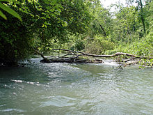
Alte Aare in the middle course |
||

The Alte Aare is the name given to the stretch of the original course of the Aare between Aarberg and Büren an der Aare . Since the first correction of the Jura waters, most of the water in the Aare has flowed through the Hagneck Canal into Lake Biel, and from there through the Nidau-Büren Canal and above Büren back into the old river bed.
The end of the course of the river Alte Aare is an oxbow lake , which the Nidau-Büren Canal cut off from the original course of the Aare and which is now part of the Häftli nature reserve .
course
The Alte Aare is the old course of the river that flows south of the old town of Aarberg in front of the dam of the Aarberg hydropower plant and after about 15 kilometers (13.1 kilometers as the crow flies) across from the Häftli , which geographically also belongs to the Alte Aare Nidau-Büren Canal (1.9 kilometers west of Büren) and thus flows back into the Aare.
The old Aare flows to Aarberg through the municipal areas of Kappelen , Lyss , Büetigen , Studen , Schwadernau , Dotzigen , Meienried , Safnern , Meinisberg and Büren an der Aare. In Lyss, just before the Busswil district , the Lyssbach flows into the Alte Aare. The level stone at Dotzigen is reminiscent of the busy ferry service before the first correction of the Jura waters between Dotzigen and Meienried.
The river runs north-northeast. The banks of the river, which is still five to seven meters wide, are difficult to access for people because of the dense bank forest with fallen trees. The water is about one and a half meters deep on average. The current is about five to six kilometers per hour.
The route is passable for kayaks and canoes, but there are some prohibitions, difficulties and dangers to be observed when using it.
Flora and fauna
Storks live in the northern part of the old Aare . Some fish species are native to the river, mainly trout and pike .
Further meaning
The 6.8-kilometer-long oxbow lake around the Häftli south of Meinisberg is often called the “old Aare”, although it is almost stagnant water that is partially swampy.
Web links
- River guide with information about the route ( Memento from November 1, 2007 in the Internet Archive )
- To the meadow landscape of the Alte Aare


