Cat lake
| Cat lake | ||
|---|---|---|

|
||
| Aerial view of the two cat lakes | ||
| Geographical location | Canton Zurich | |
| Drain | Katzenbach and Furtbach | |
| Location close to the shore | Zurich-Affoltern , Regensdorf | |
| Data | ||
| Coordinates | 679 527 / 254056 | |
|
|
||
| Altitude above sea level | 439 m above sea level M. | |
| surface | 36 ha | |
| length | 1.1 km | |
| width | 540 m | |
| Maximum depth | 8 m | |

|
||
| Map of the city of Zurich with the Katzensee at the northern end of the city | ||
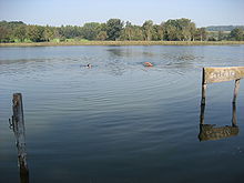
The Katzensee (or Swiss German Chatzesee ) is a lake in Switzerland on the municipality border between the city of Zurich and Regensdorf in the canton of Zurich . The small Büsisee is also counted among the Katzenseen.
topography
The lake is 1.1 km long and 0.54 km wide. It is divided into two parts, the Upper and the Lower Katzensee . Both lakes are often referred to together as cat lakes. Nearby, directly adjacent to the Zurich-Nordring motorway , is the smaller Büsisee , where the Swiss German word Büsi also means cat .
The Katzensee is drained on two sides. To the east, the Katzenbach runs underground for the first 200 meters. In the area of the city of Zurich it flows into the Leutschenbach and this into the Glatt . The Furtbach flows to the west . It flows into the Limmat at Würenlos . The Katzensee has no above-ground inflow.
Emergence
The two Katzenseen owe their creation to an Ice Age moraine , which they still hold today. The Büsisee was created as an artificial collecting basin for the drainage of the motorway section during the construction of the northern bypass.
Nature reserve
The Katzenseen, which is surrounded by reed, is located in the midst of a wetland of around 40 hectares. The two lakes are slowly silting up, and the area is a prime example of lake siltation and moor development , as both a flat moor and an upland moor have emerged in a relatively small area . The Katzenseen are always the destination of scientific excursions. 600 species of flowering plants have been recorded in the natural landscape, among which there are numerous rare representatives, as well as among the occurring breeding birds, amphibians, reptiles and insects.
The Katzenseen area was placed under protection by the Canton of Zurich as early as 1912 and was therefore largely protected from construction and amelioration. In 1977 the area was included in the federal inventory of landscapes and natural monuments of national importance .
Recreation area

There is a free lido and a nudist pool at the Katzensee . There is also the Katzensee steam train at Waldhaus Katzensee.
The Katzensee froze over in January 2006 and 2009 and was officially released for entry. According to the glaciologist, there was black ice that was compactly frozen and between 11.6 and 16 centimeters thick. Before that, the lake could be walked on in 1985 and 1991. After that, it took 11 years until January 2002 saw the word: “Ice surface free”. In February 2012 the lake froze over again.
Origin of name
The origin of the word cat lake has nothing to do with a cat. The lake was named after an Alemanni named Hatto in the 6th or 7th century AD . Over time, the "H" shifted to a "K", and the water became Katto, then Katten and finally Katzensee.
swell
- ↑ Article in the Furttaler ( Memento from September 27, 2007 in the Internet Archive ) about the origin of the name of the Katzensee
Web links
- Katzensee - Sports Office of the City of Zurich, Katzensee outdoor pool
- Katzensee bathing area
- Katzensee steam train


