
Bondasca
|
Bondasca Bundäsca |
||
 Bondasca in Bondo |
||
| Data | ||
| Water code | CH : 5467 | |
| location | Switzerland | |
| River system | Po | |
| Drain over | Mera → Adda → Po → Adria | |
| source | Vadrec da la Bondasca 46 ° 18 ′ 9 ″ N , 9 ° 36 ′ 54 ″ E |
|
| Source height | approx. 2438 m | |
| muzzle | at Bondo in the Mera coordinates: 46 ° 20 ′ 15 ″ N , 9 ° 33 ′ 15 ″ E ; CH1903: 762 858 / 133973 46 ° 20 '15 " N , 9 ° 33' 15" O |
|
| Mouth height | 798 m above sea level M. | |
| Height difference | approx. 1640 m | |
| Bottom slope | approx. 24% | |
| length | 6.9 km | |
| Catchment area | 20.93 km² | |
| Discharge at the mouth A Eo : 20.93 km² |
MQ Mq |
1.09 m³ / s 52.1 l / (s km²) |
| Left tributaries | Riale Cengalo, Trubinasca | |
The Bondasca is a seven kilometer long river that flows into the Mera at Bondo . The Bondasca flows through the Val Bondasca , a side valley of the Val Bregaglia (Bergell) , an Italian-speaking valley in the Swiss canton of Graubünden not far from the border near Chiavenna .
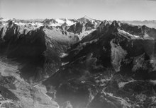

The Bondasca has its origin in the Vadrec da la Bondasca glacier , whose nutrient area also includes the peaks of the Sciora group of the Bergell Alps , which is known to mountaineers . The highest point in the Bondasca catchment area is 3370 m above sea level. M. the Pizzo Cengalo , a neighboring mountain of Pizzo Badile , the dominant mountain of the Bondasca group . To the east, the ridge Sciora Defora ( 3238 m above sea level ) - Cima della Bondasca ( 3267 m above sea level ) closes the valley.
In the valley - inward of the valley - are the Maiensasses Prä ( 1133 m above sea level ) and Selvartigh ( 1202 m above sea level ) as well as Lera ( 1286 m above sea level ) and Laret ( 1377 m above sea level ). On the Alp Sciora at the eastern end of the valley, the SAC Sciora Hut is located at 2118 m above sea level. M. , in the southern side valley Vallun da la Trubinasca, the Sasc-Furä-Hütte of the SAC at 1904 m above sea level. M.
The mouth of the Bondasca in the Mera lies below Bondo, which is in the valley funnel at 820 m above sea level. M. extends on both sides of the stream, at about 800 m above sea level. M.
Since 1962, a large part of the runoff has been collected at a height of 1080 meters and used in Bondo in a run-of-river power plant with 8 MW.
Rock falls from Pizzo Cengalo
December 27, 2011 and August 23, 2017, the valley was affected by massive rockfalls from Pizzo Cengalo, some of the largest in Graubünden in recent decades. Huge masses of rubble lie in the back valley. Debris flows of the material reached the village of Bondo in August 2012, just like at the event in 2017, and also devastated the Maiensässen in the valley.
Individual evidence
- ↑ a b c Geoserver of the Swiss Federal Administration ( information )
- ↑ a b Topographical catchment areas of Swiss waters: sub-catchment areas 2 km². Retrieved September 24, 2017 .
- ↑ Vadrec da la Bondasca on ethorama.library.ethz.ch/de/node
- ↑ Cima della Bondasca on ethorama.library.ethz.ch/de/node