
Bondo landslide
Coordinates: 46 ° 18 ′ 5 " N , 9 ° 36 ′ 10" E ; CH1903: seven hundred sixty-six thousand seven hundred and nineteen / 130075

The Bondo landslide occurred on the northern flank of Piz Cengalo ( 3369 m above sea level ) in the Bergell Alps in the Swiss canton of Graubünden . After previous rockfalls and mudslides in 2011 and 2012, the largest landslide in Graubünden in decades occurred on August 23, 2017, claiming eight lives. Debris flows through the Val Bondasca reached the village of Bondo in Bergell, about four kilometers away, and led to evacuations and destruction there.
situation
The 200-inhabitant village of Bondo, in the political municipality of Bregaglia , Maloja region , is located in the Val Bregaglia (the Bergell valley of the upper Mera ), 12 km east of Chiavenna , not far from the Italian border, at 823 m above sea level. M. Here flows from the southeast, the side valley Val Bondasca from the Bergell Alps, at the end of the valley, the Piz Cengalo rises Sciora group , just 5 km from the village.
The area is a fault zone and consists of Bergell granite ( granodiorite ), the steep northern flank of the Cengalo has become particularly unstable in recent decades , especially due to the decline in permafrost .
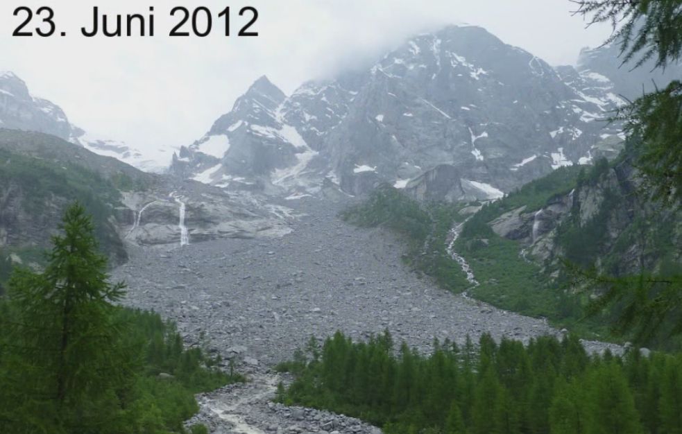
The small Bondasca valley (Val Bondasca) drops steeply into the Meratal. In the upper part it has a glacier , the Vadrec dal Cengal / Vadrec da la Bondasca , and two Alps with Maiensässen ( Lera / Laret at around 1300 m above sea level and Prä / Selvartigh at around 1150 m above sea level). The site is not directly threatened by falling rocks from the mountain flank, but primarily by sediment transport in the Bondasca stream . This risk has been known at least since the landslides of 2011 and 2012, and the acute risk was started to be evaluated in 2017 by measuring rock movements on the Cengalo.
|
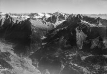
In the right third of the picture is the Piz Cengalo. In December 2011 and August 2017, the rock masses fell into the valley basin of Val Bondasca, in the center of the picture. The village of Bondo, affected by the debris flow, is in the lower left third of the image (aerial photo from 1954)
|
.png)
|
North-east flank of Piz Cengalo in 2008 before the first landslide, demolition zone marked. The downward sloping fissures of the wall can be seen.
|
Landslide 2011

On December 27, 2011, around 7 p.m., 1.5–2 million cubic meters of rock fell from the north face of the Cengalo. These remained in the rear bondasca. The earthquake service of ETH Zurich registered an earthquake with a magnitude of 2.7. The event went largely unnoticed by the public, although it was already one of the great falls in recent Swiss history.
The Vial hiking trail between Sasc-Furä- and Sciorahütte ( T4 according to SAC scale ) was buried and has since been closed due to the high risk of falling rocks , but you could still walk at your own risk. The access routes to the Sasc-Furä and Sciorahütte were not blocked. Only warnings at the huts, on hiking trails and in the village pointed out the dangers in four languages, and warnings were given against “lingering” on certain sections of the path. The huts continued to be manned. The still open access to the Sasc-Furä-Hütte (T3 according to the SAC scale) also led through an endangered area. Some known climbing routes on the Cengalo were destroyed.
In the summer of 2012, several debris flows occurred along the stream, in particular a large one on August 25, 2012 after a thunderstorm that came to the site with around 100,000 cubic meters of debris. It remained without any major harmful effects, but devastated the local campsite.
As a result, extensive construction work began and a monitoring and alarm system was installed:
- On the northeast edge of Bondo, directly in front of the bridge on Hauptstrasse 3 and the confluence of the Bondasca and Maira , an overflow basin for 50,000 cubic meters of bed load was built. A concrete wall a good 500 meters long and two meters high protects the village, which had expanded too close to the danger zone with a few houses. The project was approved by the Bergell electorate in August 2013 and implemented in 2014–2015. Due to the hard construction with a concrete wall, the project could be realized with 5.3 million francs (instead of 7 million with an earth dam). The project, which the cantonal monument protection department had also consulted, did not stand in the way of the Wakker Prize of the Swiss Heritage Protection for “successful symbiosis of settlement and landscape”, which the municipality of Bregaglia received in 2015.
- Pull cords over the Bondasca stream, about a kilometer above Bondo, ensure that the traffic lights in the valley are switched to red and that the responsible authorities in the municipality and canton are alerted by SMS. This system allows a warning time of 4 minutes until the comparatively slow debris flows reach the site. In addition, cameras and a level radar provide data on the water flow in order to assess the risk of mudflow.
- In addition, extensive observation and research activities have been started, for example by the Alpine countries working group (Arge Alp) together with the Office for Forests and Natural Hazards Graubünden (WSL), the municipality of Bregaglia, the expert offices Bonanomi AG and Terrarsense, ETH Zurich , Office for Geology in Bolzano and WSL - Institute for Snow and Avalanche Research (SLF). The decline in permafrost and the rock profile were measured and monitored using radar, laser scan and infrared (project Influence of permafrost on landslides and rockfalls , 2012-2015)
The more specific causes of the landslide in 2011 remained unexplained; the event in mid-winter could have been caused by freezing crevice water. The thunderstorm in 2012 that caused the big mudslide was not particularly intense. In the following years there were other minor falls, even without the effects of frost. A total of 3.3 million cubic meters of unstable material on the Pizzo Cengalo and a coming major fall of 2 million cubic meters were assumed around 2015. Until 2017, the measurement revealed a displacement of the mountain flank of up to 10 cm.
Landslide 2017
After geologists at the end of July 2017, during the last measurements before the event, had determined greatly increased rock movements with several smaller rock falls, the warnings were supplemented on August 14 with the notification that another landslide was on the horizon: the decline is in the coming Weeks and months to count. A ban on entering the Maiensassen in Bondasca was also imposed. Nevertheless, at this point in time, the experts saw no cause for concern and rather believed that the unstable flank would come off in smaller parts.
Event on August 23, 2017
On Wednesday, August 23, 2017, 9:30 a.m. CEST , there was an even bigger landslide than in 2011, with 3 million cubic meters of rock falling off and a speed of 250 kilometers per hour. This immediately led to a debris flow along the Bondasca. The automatic monitoring system triggered for the first time since it was installed and the village of 200 inhabitants was completely evacuated.
The mudslide drove with enormous debris up to 100 meters wide through the Bondasca valley cut between Bondo and Promontogno, but had no serious consequences in the village itself due to a collecting basin built in the river valley after the landslide in 2011. A total of twelve stables and mountain pastures in Val Bondasca and four buildings in Bondo were destroyed or damaged. The concrete bridge on Hauptstrasse 3 - the valley road in the southern Graubünden valley, which had been closed between Stampa and Castasegna - over the stream was covered by rubble and mud and shifted. The water intake of the EWZ near Prä, before the last gorge before Bondo at around 1080 meters above sea level, was run over by the debris flow and has no function under the rubble. It is a smaller power plant with an average annual output of around 18 GWh, which will therefore fail for a long time.
Climbers trapped in Val Bondasca and the Sciora and Sasc Furä huts were evacuated by helicopter on the day of the incident. The residents of the old village center were able to return to their homes on the following Friday, August 25th.
After the big landslide, eight mountaineers were missing. They were traveling in groups of two and came from Germany, Austria and Switzerland. All eight had slept in the Sciora hut; two of them wanted to climb up to the Sasc-Furä hut, the other six wanted to descend to Bondo. The number of missing persons was at times 14 people; a group of six hikers initially believed to be missing was later located in Italy. The search in the area of mass movements was finally stopped after the second debris flow.
While the rockslide was calculated very precisely in advance by the geologists in a computer simulation, they were surprised by the debris flow that started immediately, because there was no precipitation at the time in question. Rather, what led to the extraordinary event was the fall of the broken rock masses onto the small glacier below. In a matter of seconds, a lot of ice was removed, pulverized and partly melted. The released water kept the fallen rubble in motion and shaped the huge debris flow that poured through the Val Bondasca to the valley floor near Bondo.
Event on August 25, 2017
On the afternoon of August 25th there was another rock fall and renewed mudflow movement. Two excavators were buried in the lowest area near the village. Residents who had just returned were immediately evacuated. The following day they were also allowed to return to a more risky area.
The removal of the bed load material on site was tackled using heavy equipment from a specialized Zurich construction company.
Since the events, the demolition area has been re-measured using a laser scan and possible further movements have been monitored by radar. Five hundred thousand to one million cubic meters of rock are still at risk of falling. In the rear of the Bondasca valley, masses of debris up to 40 meters thick were built up.
Event of August 31st
In the night from August 31 to September 1, another large mudslide reached the bottom of the Bergell valley near Bondo. She filled the collecting basin, which had been partially emptied in the days before, passed the new cantonal road and filled the river bed of the Maira. The old cantonal road on the right side of the valley was now covered with mud. The residents and hotel guests in the local district of Spino were brought to safety.
After these debris flows, the bridge was covered by rubble up to 3 meters. The daily clearing capacity amounted to 10,000 cubic meters of material, so that a period of two months was calculated in order to empty the collecting basin filled with 400,000 cubic meters. Out of a total of 200 helpers, around 50 were each on site. People only had temporary access to the evacuated districts of Bondo, Spino and Sottoponte. For security reasons, the passage on the cantonal road near Bondo was closed at night. By September 8th, 2 million francs in donations had been collected for Bondo and the community received around one million francs in direct aid from the state.
Event on September 15, 2017
During two hours in the late evening, another 200,000 to 500,000 cubic meters of rock broke off Piz Cengalo. The departure had previously been expected for the morning of September 16. There was no debris flow at this event. The amount of rock lost was unclear for a long time, so no statement could be made about the remaining danger.
Evacuation and return
After almost two months of evacuation, a large proportion of the residents were able to return to their homes from mid-October. At the same time, work was still being carried out on emptying the retention basin for 20 hours a day. In November, most of the residents were back in the village. In December 2017, the total damage was assumed to be around CHF 41 million. 99 buildings of all types were damaged, a third of which could not be saved.
The criminal investigation into the deaths was closed in 2020.
In June 2019, a new hiking trail was opened that allows access to the reopened Sasc-Furä hut . The new hiking trail is higher up than the old one and therefore not in the danger zone. The Sciorahütte remains closed.
Happened since 2018
The Piz Cengalo also moved in August 2018 and 2019.
In August 2018, the rock on the eruption flank moved in bursts by up to 2.5 cm per day; another 3 million cubic meters could crash in the near or distant future, according to estimates. In July 2018, there was another search for the eight mountaineers who had been missing since 2017. The debris in the valley of the Bondasca was given with a thickness of up to 35 meters.
On August 14, 2019, another small rock fall occurred on Piz Cengalo, but did not cause any damage in Bondo. According to Anna Giacometti , the mayor of Bregaglia, the mountain should be permanently monitored until 2023, as there are still unstable rock masses. Several small landslides are better than one big event.
Web links
- Aerial view of the Cengalo Bondasca area. 2003 (on geo.admin.ch, via swisstopo → topic aerial photos )
- Satellite image before and after the 2017 event ( Sentinel-2 , posted on Twitter by Meteos, Aug 26, 2017).
Individual evidence
- ↑ a b Rockslide in Bergell: The most important thing about the accident at Bondo. SRF online, last updated August 25, 2017 (accessed August 27, 2017).
- ↑ cf. Rudolf Staub: Geological observations on the Bergeller massif. In: Quarterly publication of the Natural Research Society in Zurich, 63 / 1–2 (1918), pp. 1–18 ( article pdf , on ngzh.ch).
- ↑ H.-R. Wenk: Geological excursions in Bergell. Società Culturale Bregaglia, 2012, esp. Excursion 5th Val Bondasca, Trubinasca. The NW contact of the granite. P. 18ff, with detailed geological map and photo Figure 7. View from Tombal to the granite peaks in Val Bondasca , p. 13 ( pdf , centrogiacometti.ch).
- ↑ a b c d e f g h Beautiful and imposing. But dangerous. How Bondo protects himself from Piz Cengalo and Bondasca debris flows. And protection through walls, concrete walls and retention basins. The Bondasca protection project is on the home stretch. Marie-Claire Jur, in Engadiner Post , 122nd year, 84, July 21, 2015, p. 1 resp. 3 ( Repro, pdf , on engadinerpost.ch, accessed August 20, 2017).
- ↑ a b Rockslide in Bergell: "The federal government is intensifying its surveillance". SRF online, August 24, 2017 - Interview with Hugo Raetzo, Risk Prevention Department at the Federal Office for the Environment.
- ↑ a b c d e This is how Piz Cengalo was monitored / alarm system on Piz Cengalo: The stone on the cable. In: Tages-Anzeiger online, August 24, 2017.
- ↑ Photo of the SAC section Hoher Rohn, on the geopraevent.ch website : https://www.geopraevent.ch/wp-content/uploads/2013/07/FotoCengaloKegel.jpg
- ↑ Millions of cubic meters of rock lost on Pizzo Cengalo: massive rock erosion in Bergell. NZZ online, December 31, 2011 (limited preview, also devastating rock collapse in Bergell: How the landslide on Pizzo Cengalo in 2011 became public. Ibid., August 26, 2017; both accessed August 28, 2017).
- ↑ a b c d e f g h Stefan von Bergen: Rockslide: It's getting tight in the valley. In Die Zeit , year 2014, issue 36, September 1, 2014 (online at zeit.de).
- ↑ Almost unnoticed: huge landslide in Bergell. (No longer available online.) Swiss television , January 3, 2012, archived from the original on February 24, 2014 ; Retrieved July 5, 2014 . Info: The archive link was inserted automatically and has not yet been checked. Please check the original and archive link according to the instructions and then remove this notice.
- ↑ a b «They left at 8 o'clock - into the danger area». 20min.ch, August 25, 2017, accessed on August 25, 2017 .
- ↑ Tagesschau SRF, main edition, from August 26, 2017.
- ↑ a b c «We don't want a 'Great Wall of China'." Southeastern Switzerland (suedostschweiz.ch), October 12, 2014.
- ↑ Just for consolation? The Bergell receives the Wakker Prize of the Swiss Homeland Security. But not everyone in the valley is happy about it. Stefan von Bergen in Zeit online, July 13, 2015.
- ↑ Debris flow monitoring Val Bondasca. (No longer available online.) Geopraevent AG, archived from the original on August 25, 2017 ; accessed on August 24, 2017 . Info: The archive link was inserted automatically and has not yet been checked. Please check the original and archive link according to the instructions and then remove this notice.
- ↑ Debris flow is imminent: «There are 4 minutes left for the evacuation». 20min.ch, August 27, 2017 - Interview with Martin Keizer, Office for Forests and Natural Hazards.
- ↑ Arge Alp project on rock falls in permafrost: measurements in Bergell. ARGE ALP, undated .;
- ↑ Mountain and rock falls in permafrost: Arge-Alp project at Pizzo Cengalo in Bergell. ( Memento of the original from August 28, 2017 in the Internet Archive ) Info: The archive link was inserted automatically and has not yet been checked. Please check the original and archive link according to the instructions and then remove this notice. WSL-SLF, undated .; (both 2012, accessed August 28, 2017).
- ↑ The flank shifted 10 centimeters per year - that's how the rockslide in Bondo came about. Sarah Serafini, Camille Kündig in watson.ch, August 24, 2017.
- ↑ Bondo: Search for missing hikers in Switzerland. Gian Ehrenzeller in baden online, bo.de, 25 August 2017.
- ↑ a b The Piz Cengalo is in motion. Südostschweiz (suedostschweiz.ch), short message, August 14, 2017.
- ↑ This warning at Piz Cengalo was ignored. In: Tages-Anzeiger , August 25, 2017
- ↑ a b Violent landslide in Graubünden: No all-clear in Bondo GR. Andrea Cattani in blickamabend.ch, 23 August 2017 - with an image of the seismogram evidence of the fall at 07: 30: 30–07: 31: 30 UTC.
- ↑ SRF Tagesschau from August 26, 2017
- ↑ Bondo evacuated due to landslide - no passage through Bergell. In: Neue Zürcher Zeitung online, 23 August 2017.
- ↑ a b Impressive force of nature: landslide in Bondo - entire village evacuated / “They have now decided to give up the search”. swissinfo.ch, August 26, 2017.
- ↑ a b c Rockslide in Bergell: "The chances of survival of the missing are slim". SRF online, August 25, 2017 - with a map of the debris flow.
- ↑ Since the middle of August, hikers have been warned of landslides with boards. In: NZZ online, August 25, 2017.
- ↑ a b Maloja route closed due to landslide. 20min.ch, August 23, 2017.
- ↑ a b Rock fall in Bergell: Another mudslide in Bondo. Andreas Doepfner in NZZ online, August 25, 2017.
- ↑ Rockslide in Bondo GR - eight people missing. In: Tages-Anzeiger. Tages-Anzeiger, August 24, 2017, accessed August 24, 2017 .
- ↑ Rockslide in Bondo: No more hope for missing hikers. In: NZZ online, August 26, 2017.
- ↑ Pizzo Cengalo and Val Bondasca do not come to rest In: Media release canton of Graubünden, December 15, 2017.
- ↑ Walter, F., Amann, F., Kos, A., Kenner, R., Phillips, M., de Preux, A.,… Bonanomi, Y. (2020). Direct observations of a three million cubic meter rock-slope collapse with almost immediate initiation of ensuing debris flows. Geomorphology, 351, 106933 (11 pp.). https://doi.org/10.1016/j.geomorph.2019.106933
- ↑ a b «The chances of survival are no longer high». 20min.ch, August 25, 2017, accessed on August 25, 2017 .
- ↑ Rockslide in Bergell - another debris flow near Bondo - company premises flooded. SRF 4 News 6 p.m.; srf / sda / morr; hesa, August 25, 2017, accessed August 25, 2017 .
- ↑ Zurich company in Bondo, GR: "It's a great feeling to be able to help". 20min.ch, August 27, 2017.
- ↑ «We did not expect the debris flow» . SRF online, August 26, 2017.
- ↑ Rockslide in Bondo: Geologists are approaching the crash area at Piz Cengalo. SRF online, August 28, 2017.
- ↑ Rockslide in Bondo: "The danger is still great". Christian Speicher in: NZZ online, 25 August 2017.
- ↑ Alois Feusi: New debris flow: The horror in Bondo never ends. Neue Zürcher Zeitung, September 1, 2017.
- ↑ Bondo fears further debris flows
- ↑ The extent of the third landslide near Bondo is still unclear , NZZ, September 16, 2017
- ↑ The first residents are returning to Bondo , NZZ, October 14, 2017
- ↑ Die Fren von Bondo , NZZ, November 15, 2017
- ↑ Debris flows at Bondo cost around 41 million francs , NZZ, December 15, 2017
- ↑ Rockslide Bondo - Cantonal court does not want to continue investigation , SRF, January 29, 2020
- ↑ SAC hut and hiking trail open again after two years , SRF, June 28, 2019
- ↑ The mountain over Bondo is rumbling again , NZZ, 14 August 2018
- ↑ The rock loosens at Piz Cengalo , www.suedostschweiz.ch/, August 14, 2019