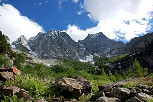
Piz Cengalo
| Piz Cengalo | ||
|---|---|---|
|
Piz Cengalo left (2008), Piz Badile right (view from the north) |
||
| height | 3369 m above sea level M. | |
| location | Graubünden , Switzerland / Sondrio , Italy | |
| Mountains | Bernina Alps | |
| Dominance | 5.8 km → Cima di Castello | |
| Notch height | 620 m ↓ Passo di Zocca | |
| Coordinates , ( CH ) | 46 ° 17 '41 " N , 9 ° 36' 7" O ( 766 675 / 129 332 ) | |
|
|
||
| rock | Granodiorite | |
| First ascent | 1866 by Douglas Freshfield and C. Comyns Tucker with guide François Dévouassoud | |
The Piz Cengalo [ tʃˈɛŋɡalɔ ] (Italian: Pizzo Cengalo ) is 3369 m above sea level. M. high mountain in the Bergell Alps . The border between Switzerland and Italy runs over the summit, between the Bergell in the south of the canton of Graubünden and the Val Masino in the northeast of the province of Sondrio .
geology
The summit area of Piz Cengalo consists of Bergell granite ( granodiorite ), in particular the steep north face of the Cengalo has become unstable due to the decline in permafrost in recent decades. There in Val Bondasca lies Vadrec dal Cengal and Vadrec da la Bondasca, a remains of a glacier.
On December 28, 2011, there was a massive rock fall in the upper part of the north face , in which around 1.5–2 million cubic meters of rock fell from the north face of the Cengalo into Val Bondasca. Another landslide occurred on August 23, 2017 with 4 million cubic meters, the largest landslide in Graubünden for decades. A mudslide reached the valley town of Bondo GR and caused major damage. Eight mountain hikers are missing and it is believed that they perished in the rock fall.
Routes and climbs
The normal route leads from the Gianetti Hut to the Cengalo Pass, from there on over the ridge to the summit. The first ascent took place on July 25, 1866 by Douglas Freshfield and C. Comyns Tucker with guide François Dévouassoud from Chamonix. The first climbs from the north led through the ice channel between Pi Cengalo and Piz Badile , the ice has now disappeared and what is left is a steep scree couloir, threatened by rockfalls.
The most famous climbing route is the Gaiser-Lehmann route over the northwest pillar (1100 m, 25 pitches, difficulty V + or VI- , base Sasc-Furä-Hütte ) in the Vallun da la Trubinasca via Bondo. Since the landslides it has been too dangerous and practically impossible to commit.
The Vial high-altitude trail between the Sasc-Furä and Sciorahütte , which crosses the northern flank of the Cengalo, has been buried since the landslide in 2017. The path was closed beforehand due to the high risk of falling rocks, but you could walk at your own risk until 2017.
Web links
Individual evidence
- ↑ A Cengalo is in Bergell dialect a hillside that is banded (from the Latin. Cingulate, ital. "Cingolo" "Rock Band").
- ↑ cf. Rudolf Staub: Geological observations on the Bergeller massif. In: Quarterly publication of the Natural Research Society in Zurich 63 / 1–2 (1918), pp. 1–18 ( article pdf , on ngzh.ch).
- ↑ H.-R. Wenk: Geological excursions in Bergell. Società Culturale Bregaglia, 2012, esp. Excursion 5th Val Bondasca, Trubinasca. The NW contact of the granite. P. 18 ff with detailed geological map and photo Figure 7. View from Tombal to the granite peaks in Val Bondasca , p. 13 ( pdf , centrogiacometti.ch).
- ↑ Other sources speak of 2 million cubic meters

