Pfäffikersee
| Pfäffikersee | ||
|---|---|---|

|
||
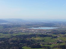
| View from Pfäffikon-Rutschberg across the lake to Auslikon and Wetzikon | ||
| Geographical location | Canton Zurich | |
| Tributaries | Chämtnerbach | |
| Drain | Ustermer Aa | |
| Places on the shore | Pfäffikon ZH | |
| Data | ||
| Coordinates | 701 346 / 245463 | |
|
|
||
| Altitude above sea level | 537 m above sea level M. | |
| surface | 3.3 km² | |
| scope | 9.051 km | |
| Maximum depth | 35 m | |

|
||
The Pfäffikersee is a 3.3 km² lake in the Zurich Oberland , Switzerland , with a catchment area of 40 km².
topography
The Pfäffikersee lies in a valley lowlands on the western edge of the hill area in the Zurich Oberland. The lake extends in a north-south direction between Pfäffikon ZH and Wetzikon with a length of 2.5 and a mean width of 1.3 kilometers. The mean lake level is 537 m above sea level. M .; the lowest point of the lake floor reaches 501 m above sea level. M. , which corresponds to a maximum depth of 36 meters; the mean depth of the lake is 18.5 meters. The distance of the ZAW hiking trail around the Pfäffikersee is nine kilometers.
The only notable tributary is the Kemptnerbach (also called Chämtnerbach in dialect ), which rises in the western Tössbergland between Bäretswil and Fischenthal below the Allmen and flows into the Pfäffikersee after about 9.5 km in the southeast. In the south, the Ustermer Aa leaves the Pfäffikersee, first flowing south and then in a north-westerly direction to Greifensee . The lakeshore is very flat on all sides except in the west.
The eponymous Pfäffikon, whose old town center is near the north bank, the farming village of Seegräben in the southwest and the city of Wetzikon in the south, have a lake share . The area around the Pfäffikersee was already settled in the Neolithic Age, as proven by numerous finds of prehistoric and early historical settlement remains ( pile dwellings ). The ruins of the Roman fort Irgenhausen are located near the east bank of the lake .
Emergence
The Pfäffikersee was formed during the last ice age, when the Linth glacier left an over-deepened tub in the Molasse underground, which filled with water after the ice retreated. The lake is dammed by a terminal moraine on the north-west and north banks, so that it cannot flow to the north-west in the direction of Winterthur . Over time, the siltation progressed. A reed and swamp belt formed almost around the lake , which in the south in the Robenhuser Riet reaches a width of about one kilometer. Peat was cut here from the beginning of the 18th century until around 1950 .
Overfertilization
The Pfäffikersee suffers from a strong over-fertilization by plant nutrients. As early as the 1950s, on the private initiative of the cable car engineer Gerhard Müller, an internal ventilation system designed by him with a tube suspended from buoys was installed. Today the oxygen circulation is stimulated by means of compressed air.
Sea frost

In prolonged, very cold weather, the Pfäffikersee can completely freeze over in winter, causing the sea to freeze . This requires an average cold total of 120 degrees (in comparison: 320 degrees are necessary for Lake Zurich and 370 degrees for Lake Constance). An ice thickness of 12 centimeters is required for the official clearance of the ice surface.
The ice was last released on February 11, 2012. Before that, in 2006 from January 26 to February 8 and from February 10 to 14. The frozen lake area was used by tens of thousands of people from near and far and used for ice skating. The lake was accessible for the first time in this century in the winter of 2002.
Nature reserve
The lake with its reed belt is a popular natural and recreational area in the canton of Zurich . It is under nature protection and has been a landscape of national importance since 1977 (property number 1409). In the protected and inaccessible reed areas you will find a unique flora with typical raised bog and flat bog plant communities.
See also
Web links
source
- Lakes in Switzerland: natural and storage lakes, Federal Office for the Environment FOEN, 2007 ( Memento of October 5, 2008 in the Internet Archive )
- Pfäffikersee - State of water quality Report by the Federal Office for the Environment FOEN of February 1, 2017 (PDF, 406 kB)
Individual evidence
- ↑ a b c d Seen (Federal Office for the Environment FOEN). Retrieved January 18, 2020 .
- ↑ Marc O. Gloor: TOUR OF THE PFÄFFIKERSEE , May 2006
- ↑ Pro Pfäffikersee: water protection measures
- ↑ Landscapes and natural monuments of national importance , accessed on December 4, 2008


