Allmen
| Allmen | ||
|---|---|---|
|
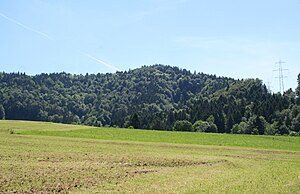
View from the northwest. |
||
| height | 1079 m above sea level M. | |
| location | Canton of Zurich , Switzerland | |
| Mountains | Zurich Oberland | |
| Dominance | 2.1 km → Bachtel | |
| Notch height | 109 m ↓ saddle south of Auenberg | |
| Coordinates | 709 562 / 241562 | |
|
|
||
|
The wooded Allmen and the Bachtel (with antenna) as seen from Rapperswil . |
||
The Allmen (also Almen ; formerly Allmann , Allman) is a wooded mountain in the Zurich Oberland with a height of 1079 m above sea level. M. It lies about 2.5 kilometers in a straight line north of the Bachtel on the territory of the municipality Hinwil in the Swiss canton of Zurich . On the northwestern flank of the Allmen, in the area of Bäretswil , is the Anabaptist Cave .
The Allmen is eponymous for the Allmannkette (also Bachtelkette ), which runs west of the Töss from the Bachtel over the Auenberg , Allmen, Stüssel ( 1052 m above sea level ), Stoffel ( 929 m above sea level ), Tämbrig ( 820 m above sea level). M. ) to Kyburg , and over the Chomberg ( 644 m above sea level ), Blauen ( 609 m above sea level ), Rhinsberg ( 567 m above sea level ), Altenhau ( Hiltenberg , 545 m above sea level ) to Rheinsfelden and forms the watershed between Töss and Glatt . The chain of hills is said to have formed the border between Zürichgau and Thurgau within the Duchy of Alamannien in the early Middle Ages .
The derivation of the name Alman ( Allmann ) from the name of the Alemanni can be found in Johannes Stumpf (1548); Franz Ludwig Haller von Königsfelden (1812) and Heinrich Meyer (1849) again expressed their approval . Ernst Förstemann (1871) considers a derivation from the personal name Adalmann or Altmann for the name element Alman- , Allmann- in addition to the origin of Alaman- . For the secondary form Wallman in Escher von der Linth, Ludwig von Bollmann (1837) suggests an echo of a word Wallmen for "haystack". The new form Allmen only became established after 1950 (adjustment to the regional form for the term " Allmende ").
“Der Allmann” was the name of a newspaper that was published in Hinwil from 1852 to 1870 (since 1960, Zürcher Oberländer ).
The Töss – Allmann Railway was a railway connection planned in 1871, which would have crossed the Allmann chain near Bussental ( Bäretswil ), but which was never realized.
Individual evidence
- ↑ in vernacular earlier also Walman (Ludwig von Bollmann: Switzerland: a handbook first for travelers . Hoffmann, Stuttgart / Zurich 1837, p. 205 ( google.ch ). )
- ^ A b J. S. Publication, JG Gruber: General encyclopaedie der Wissenschaften und Künste . 1 (Ale-Anax). Leipzig 1819, p. 173 ( google.ch ).
- ^ Charles Knapp, Maurice Borel, Victor Attinger, Heinrich Brunner, Société neuchâteloise de geographie (editor): Geographical Lexicon of Switzerland . Volume 1: Aa - Emmengruppe . Verlag Gebrüder Attinger, Neuenburg 1902, p. 36, keyword Allmann ( scan of the lexicon page ).
- ↑ Alman M [ons] with Johannes Stumpf ( Das Zürychgow . Froschauer , Zurich 1547/8).
- ^ Gerold Ludwig Meyer von Knonau: The Canton of Zurich: histor., Geograph., Statist. described . 1834, p. 29 ( google.ch ): “The range of mountains that begins at the Bachtel, extends over Kyburg, sinks down into the plain on the Rheinsberg, rises again in the Iltenberg, and the continued range of hills loses itself at Rheinsfelden due to the influence of the Glatt into the Rhine. The upper part of this 7 hour long mountain range is called, but in the language of books, the Almans Range, by the people of the Walman. "
- ↑ Markus Lutz , Anton von Sprecher, in :: Complete geographic-statistical hand-dictionary of the Swiss Confederation . tape 1 . Aarau 1856, p. 599 ( google.ch ).
- Jump up ↑ Johannes Stumpf: Common, laudable Eydgnoschektiven Stetten Landen and Völckeren Chronik Werdeniger Thaaten Beschreybung . 6th book ( 2nd chapter ): "above in the rulership of Grüningen, next to the water called Jona, the mountains called Allman or Aleman [...] next to the Gyrenbad der Alman (one has the name something from the Alemannis, with der zeyt in Turgow and Zürichgow reychsznende, received. "
- ^ Franz Ludwig Haller von Königsfelden: Topography of Helvetia under the Romans . Part 2, 1812, p. 191 ( google.ch ).
- ^ Heinrich Meyer: The place names of the Canton of Zurich (= Mittheilungen der Antiquarian Gesellschaft in Zürich . Volume 6 ). 1849, p. 110 ( google.ch ): Almenberg ( Almen , also Walman ), G. Hinwil. This mountain forms the eastern border of the K. Zurich and is also called Stössel. "Mountain of the Alamanni" (alaman), mountain where the Alamanni settled. See Schwabenbach, Wallisellen, Wallenstatt.
- ^ For the place names Allmannsdorf , Allmannsweier , Allmannshausen : Ernst Wilhelm Förstemann: Old German name book . Second, completely new edition. Second volume: Place names, 1871, p. 65 f ( google.ch ).
- ↑ Ludwig von Bollmann: Switzerland: a handbook initially for travelers . 1837, p. 204 ( google.ch ).
- ↑ For the word Walm see: Schweizerisches Idiotikon 15.1572f.
- ↑ In the National Map of Switzerland for the first time in 1953 (1: 25,000, sheet 1113 Ricken). In the Siegfried map from 1883, the mountain is called Allmann , but the courtyard west of the summit (942 m above sea level) is called Allmen . In the 1921 edition, both the mountain and the farm are called Allmann ; it was not until 1953 that Hof and Berg were both called Allmen .


