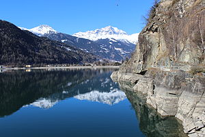
Lake Poschiavo
| Lake Poschiavo | ||
|---|---|---|

|
||
| Geographical location | Poschiavo , Switzerland | |
| Tributaries | Poschiavino | |
| Drain | Poschiavino | |
| Places on the shore | Le Prese , Miralago | |
| Data | ||
| Coordinates | 804 334 / 129098 | |
|
|
||
| Altitude above sea level | 962 m above sea level M. | |
| surface | 1.98 km² | |
| scope | 7.226 km | |
| Maximum depth | 84 m | |
|
particularities |
Natural reservoir |
|

|
||
The Lago di Poschiavo ( Eng . Puschlaversee ) is a lake in the southern Grisons valley of Puschlav . The small towns of Le Prese and Miralago are located directly on the lake ; the centers of the municipalities of Poschiavo and Brusio are 5 and 3 km away respectively.
You can reach the lake from the north via the Bernina Pass or the Forcola di Livigno , from the south via Tirano (Italy). The Bernina Railway runs for 2 km along the western bank. You can walk around the lake in two hours on a level hiking trail.
The lake was dammed by a prehistoric landslide . There is no artificial dam, only a water intake at the southern end to regulate the flow. Most of the water flows in the tunnel to Monte Scala ( 937 m above sea level ) and from there to the Campocologno power station , the remaining water takes the natural route through the Poschiavino river . The total water content is around 120 million m³ , of which 15 million m³ are used to generate electricity.
See also
List of lakes in the canton of Graubünden
literature
- Adolf Collenberg: Poschiavo, Lago di. In: Historical Lexicon of Switzerland . 2010 .
Web links
- Lago di Poschiavo on the ETHorama platform
- Lago di Poschiavo on schweizersee.ch
Individual evidence
- ↑ a b c d Seen (Federal Office for the Environment FOEN). Retrieved January 18, 2020 .
- ↑ Bad Le Prese on ethorama.library.ethz.ch/de/node
