
Brusio
| Brusio | |
|---|---|
 |
|
| State : |
|
| Canton : |
|
| Region : | Bernina |
| BFS no. : | 3551 |
| Postal code : |
7743 Brusio 7744 Campocologno 7747 Viano 7748 Campascio |
| Coordinates : | 807 075 / 126601 |
| Height : | 780 m above sea level M. |
| Height range : | 515–2898 m above sea level M. |
| Area : | 46.30 km² |
| Residents: | 1113 (December 31, 2018) |
| Population density : | 24 inhabitants per km² |
| Website: | www.brusio.ch |
 Brusio with the typical Crotti |
|
| Location of the municipality | |
  |
|
Brusio , in the Lombard local dialect Brüsc [bryʃ] ( German outdated Brüs, Rhaeto-Romanic Brüsch ), is a municipality in the southern canton of Graubünden , Switzerland . Together with the neighboring municipality of Poschiavo , Brusio forms the Puschlav valley ( Val Poschiavo in Italian ) and the Bernina region .
coat of arms
Blazon : A continuous silver cross in red.
The cross has been used as a seal image since the early 17th century, along with the motto sub hoc signo vinces . Colors of the former judicial community in Poschiavo.
geography

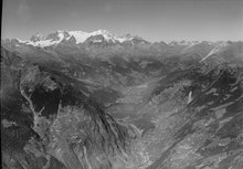
The municipality includes the lower Poschiavo and extends from the southern end of Lago di Poschiavo to the Italian border at Piattamala , which is 517 m above sea level. M. marks the lowest point of the community. The highest point is the 2901 m high Piz Combul .
In the valley floor are the main town Brusio (780 m) and, below it, the villages Campascio (637 m) and Campocologno (553 m) as well as the hamlet of Zalende . The villages of Viano (1281 m) and - scattered on extremely steep slopes at altitudes of 1300 to 1550 m - Cavaione are located on narrow terraces above the valley flanks characterized by scree slopes and loose chestnut groves . Part of Miralago as well as several mountain pastures and alpine settlements also belong to the municipality .
In 1997, 16.6% of the municipal area was used for agriculture, the forest took up 54.1% and the settlements 2.3%. 27.0% were considered unproductive.
The municipality is surrounded on three sides by Italian territory. Neighboring municipalities are adjacent to the Poschiavo the province of Sondrio belonging Grosotto , Vervio , Tirano , Tirano , Bianzone , Teglio and Chiuro .
history

The establishment of the brotherhood of San Romerio, first mentioned in 1055, played a lasting role in the settlement and reclamation of the area . Brusio was first mentioned in a document in 1106. The meaning of the place name is uncertain; possibly it is based on Celtic * brŏga «area, border», which was extended by the Latin suffix -ūsǐum . In 1222 it was named as an autonomous community, which was represented externally by a dean. Since the 14th century, the place and Poschiavo together formed a large valley community (Cumün), which joined the Church of God in 1408 .
A separate Catholic parish existed since 1501. During the Reformation , after 1590, a Protestant parish was established. After that, Catholics and Protestants were represented almost equally. At the time of the Counter Reformation , during the Graubünden turmoil , on Tuesday, July 22nd, 1620, militant Catholic Veltliners under the leadership of Giacomo Robustelli also invaded the Grisons valley community of Poschiavo , where part of the local Catholic leadership cooperated with them. This event was part of the Veltliner murder . Around 30 Reformed people perished in Brusio; However, the majority of the evangelical community had been warned and was able to withdraw to the Cavaglia plain and from there to flee to the Engadine . A decision by the Bündner Arbitration Court in 1642 enabled the Evangelicals to build their own church in 1645. As a result of these events and the increased emigration of the Reformed, their share of the population fell to 9% by 1990.
It was not until 1851 that Brusio broke away from the association with Poschiavo. Earlier striving for autonomy was not without a certain involuntary comedy. In 1615, for example, the Brusiesi drew a new community seal of their own, but had to be informed immediately by the Association of Churches that they were not entitled to such a seal.
The commissioning of the Brusio power plants in 1906 and the Bernina Railway in 1908/10 led to an economic boom in the 20th century.
Cavajon
The hamlet of Cavajone was only ceded to Switzerland by a state treaty in 1867 and assigned to the municipality of Brusio. The national border in Val dal Saent was not established until 1863 and finally in 1876. In addition to the Dappental question and the Verenahof (today part of the Büttenhardt municipality ), this is the only major modification of the Swiss national territory since 1815.
population
| Population development | |||||||||||||
|---|---|---|---|---|---|---|---|---|---|---|---|---|---|
| year | 1850 | 1880 | 1900 | 1910 | 1941 | 1950 | 1980 | 2005 | 2010 | 2017 | |||
| Residents | 1000 | 1158 | 1199 | 1320 | 1470 | 1528 | 1258 | 1198 | 1123 | 1135 | |||
In the hundred years between 1850 and 1950 the population grew strongly by 528 (= 52.8%) people. In the following three decades, on the other hand, it fell sharply again as a result of migration to industrial centers and tourist resorts (1950–1980: −17.67%). This development continues in a weaker form to this day, so that there are as many residents in 2005 as in 1900.
languages
The colloquial language of the population is the Alpine-Lombard dialect Pus'ciavin . It was spoken by 96.16% of the population in 1900. Hardly anything has changed since then, as the following table shows:
| Languages in Brusio | |||||||||
| languages | 1980 census | 1990 census | 2000 census | ||||||
| number | proportion of | number | proportion of | number | proportion of | ||||
| German | 43 | 3.42% | 45 | 3.69% | 64 | 5.32% | |||
| Romansh | 15th | 1.19% | 12 | 0.98% | 8th | 0.67% | |||
| Italian | 1,191 | 94.67% | 1,150 | 94.26% | 1,111 | 92.43% | |||
| Residents | 1,258 | 100% | 1,220 | 100% | 1,202 | 100% | |||
The official language of the municipality is Italian.
Origin and nationality
Of the 1198 residents at the end of 2005, 1108 (= 92.49%) were Swiss citizens.
economy
Several well-known wineries dominate the economic structure of the municipality, bottling the red wine grown in the nearby Valtellina - partly on their own vineyards - and selling it in Switzerland. Its large buildings are just as impossible to overlook as the warehouse of a fruit and vegetable importer. The local natural stone factory processes granite and metabasite from the quarries around Campascio.
Other important employers are the power plants , the Rhaetian Railway and the customs administration . There are also some smaller commercial and handicraft businesses, especially in the construction industry, as well as several petrol stations. Around 1995 a small company in the chemical-pharmaceutical industry settled down. Tourism plays a minor role in Brusio. Only a few exhibits in the local museum are reminiscent of the at times significant smuggling of coffee and tobacco.
166 people were employed in agriculture, 178 in manufacturing and 333 in the service sector (as of 2000–2001).
traffic

The main road 29 leads through Brusio, Campascio and Campocologno from the Bernina Pass to Valtellina. Narrow, winding roads open up the high-lying villages of Viano and Cavaione.
There are two stations and one stop on the Bernina Railway, which opened in 1908, in the municipality . Campocologno is particularly important as a border station for goods traffic . Since 1998, the Rhaetian Railway has operated a separate freight station above the station, where primarily mineral oil products and logs are handled.
Attractions

- The townscape is characterized by the baroque towers of the two churches: the Catholic parish church of San Carlo Borromeo (1617).
- Reformed parish church (1645), with a Rococo organ from Bergamo .
- Catholic Church of Santa Famiglia.
- Church of San Romerio from the 11th / 16th century on the Alpe San Romerio
- In the village center there are several stately town houses, including the Casa Besta , which has been set up as a museum .
- Casa Nussio.
- Bruno Giacometti's schoolhouse and parish hall .
- At the circular viaduct of the Bernina Railway, three sculptures by the local sculptor Cristiano Paganini were placed.
- Scattered across the entire municipality are the crotti or scélé , circular structures made of dry stone masonry that served as a cooling room for milk and cheese.
- Prayer Chapel San Gottardo in the Miralago district .
- Alp San Romerio towers high above Lago di Poschiavo with its chapel, first mentioned in 1055. The nave of the little church probably dates back to the 11th century, the choir and tower were added in the 15th to 16th centuries. From this viewpoint, which can be reached in a two-hour hike from Viano, you can enjoy a comprehensive view of the municipal area.
- Below the village is the famous Brusio circular viaduct of the Rhaetian Railway .
Events
- Il Palio delle contrade
Sons and daughters of the church
- Remo Bornatico (born October 19, 1913 in Brusio; † March 22, 1989 in Chur ), journalist, politician, Grisons Grand Councilor.
- Dino Bornatico (* 1945 in Brusio; † 2005 in Porza ), economist, media entrepreneur
- Ettore Mazzoleni (born June 18, 1905 in Brusio, † June 1, 1968 in Oak Ridges ), Canadian conductor and music teacher of Swiss origin
- Gaudenz de Misani (born September 25, 1743 in Brusio; † after 1795 ibid), lawyer, 1763–1765 Podestà in Plurs , 1771–1773 governor of Podestà in Tirano
- Johann Theodor de Misani (* around July 5, 1752 in Brusio; † June 27, 1813 there), 1774–1775 Mayor of the Court of Sur Funtauna Merla
- Remigio Nussio (born July 29, 1919 in Brusio; † 2000 ibid), musician and composer
literature
- Fernando Iseppi: Brusio. In: Historical Lexicon of Switzerland . September 1, 2004 , accessed December 29, 2019 .
- Simona Martinoli u. a .: Guida d'arte della Svizzera italiana. Edited by the Society for Swiss Art History . Edizioni Casagrande, Bellinzona 2007, pp. 556-559.
- Erwin Poeschel : The art monuments of the canton of Graubünden. Volume VI: The Italian Grisons valleys Puschlav, Misox and Calanca (= Swiss art monuments. Volume 17). Edited by the Society for Swiss Art History GSK. Bern 1945, ISBN 978-3-906131-55-9 .
- Tomaso Semadeni: Brusio. In: Historical-Biographical Lexicon of Switzerland , Volume 2: Brusino - Caux. Attinger, Neuenburg 1921, p. 381 ( digitized version ).
Web links
- Brusio on the ETHorama platform
- Official website of the municipality of Brusio (Italian)
- Brusio in Graubünden Online (German)
- Federal inventory ISOS: Cavaione
- Brusio on elexikon.ch
Individual evidence
- ↑ Permanent and non-permanent resident population by year, canton, district, municipality, population type and gender (permanent resident population). In: bfs. admin.ch . Federal Statistical Office (FSO), August 31, 2019, accessed on December 22, 2019 .
- ↑ a b Lexicon of Swiss municipality names . Edited by the Center de Dialectologie at the University of Neuchâtel under the direction of Andres Kristol. Huber, Frauenfeld and Payot, Lausanne 2005, p. 193 f.
- ↑ Fernando Iseppi: Brusio. In: Historical Lexicon of Switzerland . September 1, 2004 .
- ↑ Adolf Collenberg: Cavajone. In: Historical Lexicon of Switzerland . September 1, 2003 .
- ↑ Fernando Iseppi: Brusio. In: Historical Lexicon of Switzerland . September 1, 2004 .
- ↑ Parish Church of San Carlo Borromeo on graubuendenkultur.ch
- ^ Reformed Church on graubuendenkultur.ch
- ↑ Catholic Church of Santa Famiglia on graubuendenkultur.ch
- ↑ Casa Besta on graubuendenkultur.ch
- ↑ Casa Besta (museum)
- ↑ Casa Nussio on graubuendenkultur.ch
- ^ Crott's group on graubuendenkultur.ch
- ↑ San Romerio on graubuendenkultur.ch
- ↑ Circular viaduct of the Bernina Railway on graubuendenkultur.ch
- ↑ Michela Nussio, Oltre i colori della contrada. Uno sguardo antropologico sul Palio delle contrade di Brusio. (Italian) at e-periodica.ch/digbib, accessed on January 11, 2017.
- ↑ Fernando Iseppi: Remo Bornatico. In: Historical Lexicon of Switzerland . August 17, 2004 , accessed December 15, 2019 .
- ↑ Jürg Simonett: Misani, Gaudenz de. In: Historical Lexicon of Switzerland . November 11, 2008 , accessed April 5, 2020 .
- ^ Cesare Santi, Documenti sulla vicenda di Gaudenzio Misani. (Italian) at e-periodica.ch/digbib, accessed on January 13, 2017.
- ↑ Jürg Simonett: Misani, Johann Theodor de. In: Historical Lexicon of Switzerland . November 13, 2008 , accessed April 5, 2020 .
- ↑ Remigio Nussio. Retrieved September 13, 2019 (German).