Verenahof
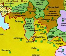
The Verenahof (also known as Büttenharter Hof or Verenahöfe ) is part of the Swiss municipality of Büttenhardt . It is an area occupied by three residential buildings, which until 1967 was an exclave of the German community of Wiechs am Randen . It was separated from this by a 200 to 300 meter wide strip of Swiss territory. Together with Wiechs am Randen, the farm originally belonged to the front county of Tengen .

From the history of the Verenahof
In 1522, Emperor Charles V and his brother Archduke Ferdinand of Austria bought the Verenahof together with other territories in the vicinity ( Tengen , Kommingen , Wiechs am Randen, etc.) from Count Christoph von Nellenburg-Tengen . He expressly did not want to sell these properties to Schaffhausen because he felt that the Schaffhausen residents had treated him badly. In the 17th and 18th centuries there were repeated disputes between Tengen and the canton of Schaffhausen over the access routes and the exact demarcation of the boundaries. The residents of Verenahof were Catholic at the time, but the residents of Büttenhardt were Protestant. On Catholic holidays, the residents of the Verenahof denied the residents of Büttenhardt the right of passage.
In 1806 the Verenahof became a Baden exclave within the Swiss canton of Schaffhausen . In 1815 and 1839, Swiss attempts to get the Verenahof failed.
From 1829 there was a school in Wiechs am Randen, which the children from Verenahof attended. The residents of the Verenahöfe in 1855 were Protestant like their Büttenhardt neighbors, they were the small Protestant minority within the otherwise completely Catholic community of Wiechs am Randen.
In the 1920s there were attempts to integrate the Verenahöfe into Switzerland, but the Baden Ministry of the Interior repeatedly refused. In the 1930s, numerous new boundary stones were set around the exclave. This can be seen from the preserved boundary stones that can be found in Büttenhardt itself and at the «Jägerhütte». They are labeled B (= Baden), LG (= national border), S (= Switzerland) and the year 1935. Most of the boundary stones in the wider area, however, date from 1839. On April 30, 1945, four German officers managed to enter the exclave area. However, since the police force on the territory was contractually granted to Switzerland, they were expelled from there.
A treaty between Germany and Switzerland signed in 1964 , which came into force on October 4, 1967, transferred the 43 hectare area of the Verenahof to Switzerland as part of an exchange of territory. In Wiechs am Randen there are some boundary stones at the town hall that have become superfluous due to the exchange of areas in 1967 along the old main border. In Büttenhardt, some old boundary stones from the 1930s, which stood around the exclave, are used as souvenirs to frame a bush plant near the old school house.
See also
literature
- Municipality of Büttenhardt: border adjustment 1967 - Verenahof - Büttenhardt . 2nd Edition. 1992
- Franz Götz (Ed.): Tengen - History of the City and its Localities , Hegau Library Volume 79, 1991, ISBN 3-921413-31-1
Web links
- Matthias Wipf: Verenahof. In: Historical Lexicon of Switzerland .
- Swisstopo, a topographical journey through time from 1850 to today. The spelling Büttenhard appears on the cards up to 1882 ; the exclave has been called the Driangel .
- Albert Bittlingmaier: Sheer chaos at the border state act 50 years ago. Südkurier , October 3, 2017.
Individual evidence
- ↑ a b Götz 1991, pp. 101-102
- ↑ Götz 1991, p. 119
- ↑ Schaffhausen state territory and national emblem , accessed on December 12, 2019
- ↑ Götz 1991, p. 478
- ↑ Götz 1991, p. 285
- ↑ Götz 1991, p. 482
- ↑ BGBl. 1967 II, pp. 2041-2043
- ↑ Treaty between the Swiss Confederation and the Federal Republic of Germany on the adjustment of the border in the Konstanz – Neuhausen am Rheinfall section , accessed on December 12, 2019. The Verenahof is the one specified in Article 1, Paragraph 2, lit. e named area.
Coordinates: 47 ° 45 '26.6 " N , 8 ° 39' 4.5" E ; CH1903: 690922 / 290349


