Büttenhardt
| Büttenhardt | |
|---|---|
| State : |
|
| Canton : |
|
| District : | Reiat |
| BFS no. : | 2914 |
| Postal code : | 8236 |
| Coordinates : | 690 842 / 289526 |
| Height : | 658 m above sea level M. |
| Height range : | 508–688 m above sea level M. |
| Area : | 4.00 km² |
| Residents: | 416 (December 31, 2018) |
| Population density : | 104 inhabitants per km² |
| Website: | www.buettenhardt.ch |
|
Büttenhardt |
|
| Location of the municipality | |
Büttenhardt is a municipality in the canton of Schaffhausen in Switzerland on the German border . The former German exclave Verenahof is located in the municipality .
history
In 1238 the village was first mentioned as Butinhart . In 1259, the Paradies monastery received the forest from Count Hartmann the Elder of Kyburg , which is called Buothenhart . In the 15th century everything came to Schaffhausen . Only the Verenahof stayed with Tengen because of bad policies . The Verenahof then became Baden and formed a German exclave in Switzerland for centuries . In 1967, the German exclave Verenahof was annexed to Switzerland as the last swap of territory to date. Some of the boundary stones that have become superfluous can be seen at the old schoolhouse and the town hall in Wiechs am Randen .
coat of arms
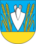
- In blue, a white ploughshare stuck with the tip in the ground, each with two yellow stylized ears of wheat.
Büttenhardt is one of the communities that did not have their own coat of arms before 1800. At the beginning of the 19th century, when it became customary for the municipalities to carry a coat of arms, they chose the plowshares stuck in the ground and surrounded by ears as a symbol for agriculture. They chose the tincture based on the Landgraviate of Nellenburg , where the village used to be.
population
| Population development | |
|---|---|
| year | Residents |
| 1836 | 148 |
| 1850 | 195 |
| 1880 | 220 |
| 1900 | 166 |
| 1910 | 142 |
| 1930 | 167 |
| 1950 | 192 |
| 1970 | 161 |
| 1990 | 269 |
| 2000 | 342 |
| 2006 | 352 |
| 2017 | 376 |
gallery
literature
- Kurt Bächtold: The history of the community Büttenhardt , Büttenhardt 1988.
- Büttenhardt community (ed.): The Verenahof zu Büttenhardt. 25 years of border adjustment in 1992.
- Andreas Schiendorfer: Thayngen 1000 Years , Anniversary Book , Thayngen 1995, ISBN 3-905116-03-0 .
- Schaffhauser Magazin 1/1980 "Reiat", Steiner Grüninger AG publishing house.
Web links
- Website of the municipality of Büttenhardt
- Andreas Schiendorfer: Büttenhardt. In: Historical Lexicon of Switzerland .
- Article in Südkurier on the area exchange between Germany and Switzerland 50 years ago
Individual evidence
- ↑ Permanent and non-permanent resident population by year, canton, district, municipality, population type and gender (permanent resident population). In: bfs. admin.ch . Federal Statistical Office (FSO), August 31, 2019, accessed on December 22, 2019 .
- ^ Bruckner-Herbstreit, Berty: The emblems of the state of Schaffhausen and its communities, Reinach-Basel 1951, pp. 187–188.


