Buchberg SH
| SH is the abbreviation for the canton of Schaffhausen in Switzerland and is used to avoid confusion with other entries of the name Buchberg . |
| Buchberg | |
|---|---|
| State : |
|
| Canton : |
|
| District : | Schaffhausen |
| BFS no. : | 2933 |
| Postal code : | 8454 |
| Coordinates : | 683 632 / 269 032 |
| Height : | 487 m above sea level M. |
| Height range : | 343-546 m above sea level M. |
| Area : | 5.86 km² |
| Residents: | 866 (December 31, 2018) |
| Population density : | 148 inhabitants per km² |
| Website: | www.buchberg.ch |
|
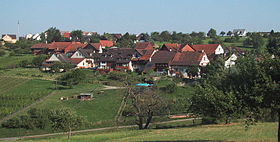
View of Buchberg |
|
| Location of the municipality | |
Buchberg is a municipality in the canton of Schaffhausen in Switzerland .
geography
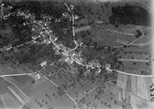
Buchberg lies opposite the confluence of the Töss River into the Rhine , between the communities of Eglisau and Rüdlingen , on the southern slope of the Hurbig . Together with Rüdlingen, in which the municipality itself has two exclaves , Buchberg forms an exclave of the canton of Schaffhausen, which is completely surrounded by the canton of Zurich and the German state of Baden-Württemberg . The two communities form the southern part of the canton.
history
In 1123 a Leuthold von Weissenburg donated the villages of Buchberg and Rüdlingen to the Rheinau monastery . For the next four hundred years, church taxes had to be brought to Rheinau . In 1520 the city of Schaffhausen first acquired the lower bailiff, and then in 1657 also the upper bailiwick of Rheinau Abbey. For these reasons, Buchberg is still part of the canton of Schaffhausen today. Up until the beginning of the 19th century, Buchberg and Rüdlingen together formed one community, from which the two political communities Buchberg and Rüdlingen emerged after the division in 1839. In the 20th century Buchberg developed from an agricultural place to a residential community with viticulture .

coat of arms
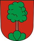
- A green beech tree in a red sign on a green three-mountain.
The coat of arms appears for the first time in 1597 as a typically speaking coat of arms ; a green beech tree on a green tripod on a yellow background. For inexplicable reasons, Buchberg wore a three-leaf clover in his coat of arms in the 19th century. Since the origin of this coat of arms was completely in the dark, the municipal assembly in 1949 chose the original coat of arms, but with a different shield color. From a heraldic point of view, however, the yellow shield color would have been preferable to the red one.
Attractions
The reformed church was built in 1850. It burned down in November 1972, and in August 1974 it was re-inaugurated after being rebuilt. The parish hall from 1856 originally served as a school and parish hall.
Town twinning
Since 1976 there has been a partnership with the city of Schnaittenbach in Germany (east of Nuremberg), which includes the Kemnath am Buchberg district .
literature
- Susanna Baur, Karin Lüthi: Cross-border commuters and bridge builders. A portrait and picture book from Tuscany Schaffhausen , Buchberg o. J.
Web links
- Official website of the municipality of Buchberg
- Andreas Schiendorfer: Buchberg. In: Historical Lexicon of Switzerland .
- Photo collection on the landscape around Buchberg SH
Individual evidence
- ↑ Permanent and non-permanent resident population by year, canton, district, municipality, population type and gender (permanent resident population). In: bfs. admin.ch . Federal Statistical Office (FSO), August 31, 2019, accessed on December 22, 2019 .
- ↑ Information on the Buchberg community website
- ^ Presentation of the local history on the website of the municipality of Buchberg
- ^ Bruckner-Herbstreit, Berty: The emblems of the state of Schaffhausen and its communities, Reinach-Basel 1951, pp. 184-185.
- ↑ Markus Späth-Walter (2002): Schaffhauser cantons history of the 19th and 20th centuries , Volume 3 ("Everyday life, society, culture, settlement, religion, literature, register"), Meier (publisher), p. 1780.
- ↑ Information on the Buchberg community website


