
Wilchingen
| Wilchingen | |
|---|---|
 |
|
| State : |
|
| Canton : |
|
| District : | Unterlettgau |
| BFS no. : | 2974 |
| Postal code : | 8217 Wilchingen 8218 Osterfingen |
| Coordinates : | 677 216 / 280064 |
| Height : | 419 m above sea level M. |
| Height range : | 389–642 m above sea level M. |
| Area : | 21.10 km² |
| Residents: | 1737 (December 31, 2018) |
| Population density : | 82 inhabitants per km² |
| Website: | www.wilchingen.ch |
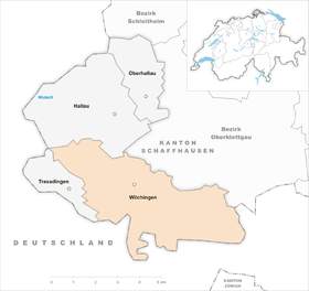
| Location of the municipality | |
  |
|
Wilchingen is a municipality in the Swiss canton of Schaffhausen . It consists of the villages Wilchingen and Osterfingen. These formed their own communities until 2005 and were merged after a referendum.
geography
The community is located in the Klettgau , in the hills of the southern edge . The climate is extremely mild with an above-average number of sunny days for this northern latitude and a low amount of precipitation due to the protected location in side valleys of the southern edge. A special feature is the south-facing Wangental , which is under nature protection and provides a habitat for many orchids . The medieval ruin Radegg towers high above the Wangental on a rocky promontory of the Rossberg .
The border between Germany and Switzerland runs to the south . The waters in the municipality are Seltenbach and Ernstel.

history


Various prehistoric traces can be found in the municipality of Wilchingen, in the valley floor a Roman road led to Tenedo ( Bad Zurzach ) and the remains of protective walls against the Teutons were found. As possession of the monastery Rheinau was Wilechinga 1049 first mentioned, the settlement was, however, earlier by a Alemanni founded called Willico with his family. In 1371/1373 the Wilchinger Vogteirechte passed to the Spital in Schaffhausen , which administered like a monastery, lands and manors in the Klettgauer Land. In 1515, after years of quarreling among those who went to church in Wilching, who had previously had to go to church in the neighboring Habsburg town of Erzingen , their own parish was set up. The church of St. Othmar was also built in 1515 on a vineyard slope above the village and had to be expanded in 1588. Ore mining and viticulture made the community quite prosperous and the population grew steadily. The first school building was set up in 1816 and expanded in 1845. In 1863 the Baden Railway was inaugurated, which was supposed to connect the community to the regional transport network. In 2006 the municipality of Osterfingen was merged with Wilchingen.
coat of arms
- In red upright white ploughshare covered with a red paw cross.
The coat of arms can be found for the first time on a coat of arms disk in 1569. It depicts a knight on foot with a flag and shield with a white cross. Presumably it is Saint George or Mauritius . In the latter case, it could be confused with Hallau. In any case, there must be an error with this coat of arms. A second coat of arms from this period refers to the connection with the Heiliggeistspital in Schaffhausen. It depicts a white cross in black, i.e. the hospital coat of arms in wrong colors. The oldest reference to today's coat of arms is on a coat of arms disk from 1575. It shows the upright, silver ploughshare, covered by a red cross on a red background. 1610 The first Wilchingen seal can be found with that symbol. To this day there is no other coat of arms than this plowshare with the cross. The only changes are decorations (e.g. laurels or vines). During the adjustment in 1950, the choice of the coat of arms with the colors of 1575 was not a topic of discussion.
economy
Agriculture
Both villages have an old wine-growing tradition and produce wines of considerable quality. Various presses and wine cellars are located in the villages and invite you to traditional wine festivals every autumn. Probably the most famous wine cellar is Bad Osterfingen on the road to Jestetten and also houses a well-known dining restaurant. Agriculture and forestry are also carried out in the surrounding forests.
traffic

Together with the neighboring municipality of Hallau, Wilchingen owns a regional train station of the Deutsche Bahn on the Schaffhausen – Waldshut line , which is around 3 km outside the village center near the Untereuhaus hamlet. From here trains run every half hour in both directions. These trains are operated alternately by Deutsche Bahn and SBB. Osterfingen and the neighboring village of Halau are connected by the Schaffhausen bus company "SchaffhausenBus".
Despite the connection to public transport, the community is considered to be remote from a traffic point of view because the train station is outside the center. The important connection road to Jestetten (Germany), which is the direct route to Bülach and Zurich , is still not accessible by public transport.
Attractions
photos

Center of Wilchingen, in the background the church of St. Othmar

Half-timbered house in Wilchingen
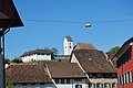
St. Othmar Church in Wilchingen

Rossberg restaurant

Gasthaus Community House in the center of Wilchingen

Osterfingen

St. Jakob Church in Osterfingen

Gasthaus Bad Osterfingen


Personalities
- Ferdinand Vetter (1847–1924), Germanist
- Albert Bächtold (1891–1981), dialect writer
- Alfred Bollinger (1896–1992), journalist and politician
- Ruth Blum (1913–1975), author and teacher
- Hans Ritzmann (* 1933), former canton judge, winemaker, poet, dialect author
- Lisa Stoll (* 1996), alphorn soloist
literature
- Kurt Bächtold : History of Wilchingen. Wilchingen 1988.
- Roman Sigg: Osterfingen. In: Historical Lexicon of Switzerland .
- Martin Akeret Weishaupt: Wilchingen. In: Historical Lexicon of Switzerland .
Web links
Individual evidence
- ↑ Permanent and non-permanent resident population by year, canton, district, municipality, population type and gender (permanent resident population). In: bfs. admin.ch . Federal Statistical Office (FSO), August 31, 2019, accessed on December 22, 2019 .
- ↑ Bruckner-Herbstreit, Berty: The emblems of the state Schaffhausen and its communities, Reinach-Basel 1951, pp. 318–327
Hallau |
Oberhallau |
Trasadingen |
Wilchingen
Former municipality:
Osterfingen
[Canton Schaffhausen]] | Districts of the Canton of Schaffhausen | Municipalities of the canton of Schaffhausen
Barges | Beggingen | Beringen | Book | Buchberg | Büttenhardt | Dörflingen | Gächlingen | Hallau | Hemishofen | Wages | Löhningen | Merishausen | Neuhausen am Rheinfall | Neunkirch | Oberhallau | Ramsen | Rüdlingen | Schaffhausen | Schleitheim | Siblings | Stein am Rhein | Stetten | Thayngen | Trasadingen | Wilchingen
Former municipality: Altdorf | Barzheim | Beavers | Book thales | Guntmadingen | Hemmental | Herblings | Hofen | Opfertshofen | Osterfingen
Canton of Schaffhausen | Districts | Municipalities of the canton of Schaffhausen