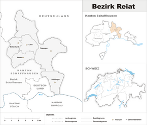
Reiat district
| Reiat district | |
|---|---|
| Basic data | |
| Country: |
|
| Canton : |
|
| Main town : | |
| FSO number : | 1402 |
| Area : | 39.33 km² |
| Height range : | 391–705 m above sea level M. |
| Residents: | 9006 (December 31, 2018) |
| Population density : | 229 inhabitants per km² |
| map | |
Until July 1999, the Reiat district was an administrative unit of the canton of Schaffhausen in Switzerland. Since then, the canton has dispensed with the district administration, but not the district itself.
Municipalities
| coat of arms | Name of the parish | Population (December 31, 2018) |
Area in km² |
Inhabitants per km² |
|---|---|---|---|---|
| Büttenhardt | 416 | 4.00 | 104 | |
| Dörflingen | 1028 | 5.82 | 177 | |
| Wages (SH) | 758 | 4.87 | 156 | |
| Stetten (SH) | 1351 | 4.72 | 286 | |
| Thayngen | 5453 | 19.92 | 274 | |
| Total (5) | 9006 | 39.33 | 229 | |
Changes in the community
- 2009: Merger Altdorf , Bibern , Hofen , Opfertshofen → Thayngen
Individual evidence
- ↑ Permanent and non-permanent resident population by year, canton, district, municipality, population type and gender (permanent resident population). In: bfs. admin.ch . Federal Statistical Office (FSO), August 31, 2019, accessed on December 22, 2019 .
- ↑ Federal Statistical Office Generalized Limits 2020.


