
Chur
| Chur | |
|---|---|
 |
|
| State : |
|
| Canton : |
|
| region : | pleasure |
| BFS no. : | 3901 |
| Zip code : | 7000–7007 Chur 7023 Haldenstein 7026 Maladers 7062 Araschgen |
| UN/LOCODE : | CH CHR |
| Coordinates : | 759662 / 190702 |
| height : |
593 m above sea level M |
| Altitude range : | 537-2753 m above sea level M |
| Area : | 54.24 km² |
| Resident: | 37,424 (December 31, 2020) |
| population density : | 690 inhabitants per km² |
|
Percentage of foreigners : (residents without Swiss citizenship ) |
20.9% (December 31, 2020) |
| Mayor : | Urs Marti ( FDP ) |
| site: | www.chur.ch |
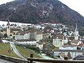
 Chur seen from the Fürhörnli, 2008 |
|
| location of the community | |
  |
|
Chur ( French Coire ; Italian Coira ; Rhaeto -Romanic Cuira ) is the capital of the Swiss canton of Graubünden and the Plessur region . Chur is located on the right bank of the Alpine Rhine and is the seat of the Diocese of Chur .
Surname
In the local dialect the name is pronounced as [ ˈkʰuːr ] or [ ˈkʰʊːr ], in other German dialects of Graubünden and in Switzerland as a whole as [ ˈxuːr , ˈxʊːr ]. The Romansh pronunciations are cuira ( Rumantsch Grischun ), ( Vallader ), ( puter ), ( Sursilvan ), Cuira ( Sutselvan ), Coira or Cuoira ( Surmirian ); cf. also Italian Coira , French Coire and Medieval Latin Curia R(h)aetorum .
The older research derived the first time around 280 in a Roman street directory (itinerarium Antonini) attested as a Curia place name from Latin cūria 'town hall, senate assembly' and summarized it as cūria Raetia prīma 'main town, administrative seat of the province of Raetia prima' . However, the linguist Johann Ulrich Hubschmied pointed out that the root vowel of today's Romansh forms Cuera, Cuoira etc. cannot go back to an ū (long u), but only to an ǔ (short u) or an ō (long o). The historian Theodor Mommsen had already rejected the derivation of cūria , since Chur was not the capital of Raetia prima at the time of the first document. Hubschmied therefore put the name to Celtic cŭria or older *korjā, *korā 'tribe, clan' , maybe also 'ancestral seat', a word that is found in the Celtic languages and in many place names (and by the way with Old High German heri 'army' is ancestral). This interpretation is undisputed today. The open pronunciation as [ ʊː ] in the older recent dialect also speaks for an originally short u .
geography


Chur is located in the wide valley of the Alpine Rhine , which, coming from the west, bends northwards here, which it essentially retains up to Lake Constance. The Plessur flows from the right , a wild river rich in sediment, which breaks through the layers of Graubünden slate between Montalin and Dreibündenstein in a deeply cut gorge. With its debris, it shifts the bed of the Rhine to the flank of the Calanda : The wide alluvial fan deposited by the Plessur in the main valley - a quarter circle with a radius of 2.5 kilometers - consists of Bündner slate while the Calanda is made of limestone . The entire territory of the city on the right bank of the Rhine reaches its greatest heights in the north-east at the Fürhörnli ( 1886 m above sea level ), in the south at the Spundisköpf ( 1847 m above sea level ), the lowest point is the Rhine on the northern municipal border (just under 550 m above sea level ).
Starting from the right bank of Plessur, below the bishop's farm standing on a ridge of rock, the settlement area gradually spread to the alluvial fan, so that the development almost reached the Rhine and the town center grew together with the hamlet of Masans , 2 kilometers to the north .
In 1997, 52 percent of the area was covered by forest and wood; 50 percent in 2021. Agriculture used 19 percent, settlements occupied 25 percent, and 4 percent was considered unproductive. In addition to the Calanda (highest point in the city at 2805 m since the incorporation of Haldenstein on January 1, 2021), Chur's "local mountains" are the Mittenberg with the Fürhörnli and the Montalin above it, as well as the Pizokel . The northern slope of the Pizokel on the border to Ems with the Rüfe in the local Val Parghera gained some notoriety . In 2013, several hundred thousand cubic meters of debris moved from there down to the catch basin, which was soon to be filled. It was directed to agricultural land to protect the highway and railway line. The cantonal road was initially interrupted and then ran through a temporary solution for a few years. In 2019, the new sediment trap costing 26 million Swiss francs with a capacity of 170,000 cubic meters was completed.
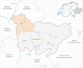
Neighboring communities are Felsberg , Trimmis , Arosa , Tschiertschen-Praden , Churwalden , Malix , Domat/Ems , Untervaz and Pfäfers in the canton of St. Gallen .
city quarters
| quarters | No. | BFS code |

|
|---|---|---|---|
| old town | 1 | 3901001 | |
| sand | 2 | 3901002 | |
| barracks quarters | 3 | 3901003 | |
| industrial area | 4 | 3901004 | |
| Loestrasse-Lürlibad | 5 | 3901005 | |
| Masans | 6 | 3901006 | |
| Rheinquartier I | 7 | 3901007 | |
| Rheinquartier II | 8th | 3901008 |
climate
The annual mean temperature for the normal period 1991-2020 is 10.3 °C, with the coldest monthly mean temperatures being measured in January at 1.0 °C and the warmest in July at 19.3 °C. On average, around 73 frost days and 10 ice days can be expected here. There are around 56 summer days on average over the year, while there are up to 15 hot days on average. The MeteoSwiss weather station is at an altitude of 556 m above sea level. M
| Chur | ||||||||||||||||||||||||||||||||||||||||||||||||
|---|---|---|---|---|---|---|---|---|---|---|---|---|---|---|---|---|---|---|---|---|---|---|---|---|---|---|---|---|---|---|---|---|---|---|---|---|---|---|---|---|---|---|---|---|---|---|---|---|
| climate diagram | ||||||||||||||||||||||||||||||||||||||||||||||||
| ||||||||||||||||||||||||||||||||||||||||||||||||
|
Monthly average temperatures and precipitation for Chur
Source: MeteoSwiss, normal period 1991-2020
|
||||||||||||||||||||||||||||||||||||||||||||||||||||||||||||||||||||||||||||||||||||||||||||||||||||||||||||||||||||||||||||||||||||||||||||||||||||||||||||||||||||||||||||||||||||
story
Pre-Roman period


Some sensational finds from the Sennhof/Karlihof area prove the presence of people in the area of today's Chur even for the period 11,000 BC. Archaeological finds show that Chur was settled as early as the Neolithic Age (around 4,500 BC), although it cannot be assumed that there was a permanent, permanent settlement at this time. Settlement remains and objects from the Bronze and Iron Ages are documented for the Welschdörfli area and the Sennhof/Karlihof area.
Chur is therefore often referred to as the oldest city in Switzerland, but this can be described as a tourist marketing slogan following the sensational finds in the Karlihof area.
antiquity
After the Romans in 15 BC. Rhaetia had been conquered and made into the province of Raetia in what is now Welschdörfli . In various excavations, especially since the 1960s, important parts of this ancient small town have been uncovered - mostly residential buildings, but also public buildings, various buildings for trade and crafts and at least one thermal baths . In 1965, a piece of an inscription honoring Augustus' son Lucius Caesar was found on the square in front of what was then the market hall (today: Stadthalle), which was probably originally part of an honorary monument such as a triumphal arch .
Further traces of Roman settlements have been found on the " Hof ", a rocky plateau with a triangular ground plan that slopes southwards towards the Plessur. There was a fort there at the latest in the late Roman period (3rd to 5th centuries) - whether this already existed during the imperial period is not certain. The diocese of Chur probably developed from this military structure as early as the 4th century AD , making it the first diocese north of the Alps. The first bishop known by name is Asinio , who is attested in 451. The first phases of Chur Cathedral and the bishop 's residence probably also date from this period . The settlement center shifted to the right bank of the Plessur.
Chur was already a local administrative center in the first centuries of its existence, which is indicated, among other things, by the honorary monument to Lucius Caesar. After the division of Raetia under Emperor Diocletian , the town may have become the capital of the newly founded province of Raetia prima , which stretched from Lake Constance to the northern Italian lakes and the Vinschgau . This is mainly supported by the fact that late antique dioceses often arose out of political administrative structures.
During the Migration Period , Chur served as the northern outpost of the Ostrogothic Empire and then came under Frankish rule in the 6th century.
middle age
In the 9th century the city was under Emperor Ludwig the Pious . Only when the empire had stabilized in the 10th century after the clashes with the Magyars (925/926 destruction of the cathedral) and Saracens (940 numerous houses burned and 954 further Saracen invasions) did Chur's great advantage come into play: its favorable location on one of the most important north-south routes in Europe. The wide Rhine valley opens up to those coming from the north as the natural gateway to the Graubünden pass region. Here the path branches off to the Alpine crossings: Julier and Septimer on the one hand, Splügen and San Bernardino Pass on the other, all of which had been used since Roman times and now gained decisive importance for the politically and militarily committed Roman-German emperors on both sides of the Alps. Otto the Great installed his vassal Hartpert as bishop in 951 and endowed the diocese with extensive rights and possessions in 958. The secular power of the bishops, who were elevated to the rank of imperial princes in 1170 , was based primarily on the Septimer route, which they completely controlled from Chur to Chiavenna .
In the 13th century, the settlement, which at that time had a good 1000 inhabitants (craftsmen, traders, farmers), was surrounded by a city wall. The city did not grow beyond this medieval boundary – the Hof in the east, the Plessur in the south, the fortifications along today’s Grabenstrasse in the northwest – until the 18th century. The rural Welschdörfli remained outside the wall.
turn to modern times
The founding of the League of Gods in 1367 marked the first major step in the citizens' striving for self-government. At that time, the first city regulations were created, and a mayor was mentioned for the first time in 1413. By storming the episcopal residence several times between 1418 and 1422, the people of Chur forced the city ruler to make concessions. The bishop, who often acted as a vicarious agent of the House of Habsburg , lost power and prestige.
On April 27, 1464, large parts of the city fell victim to a fire. German-speaking craftsmen in particular were responsible for the reconstruction. After the work was done, they stayed in Chur, which led to the advance of the German language in Chur. To protect their interests, they joined together in guilds .
The citizens of Chur sent the town clerk Johannes Gsell to Emperor Friedrich III. and asked for help. The king confirmed the old rights and granted almost complete liberation from episcopal rule. The new constitution was essentially based on the newly founded five guilds (vine workers, shoemakers, tailors, blacksmiths, Pfister ). Only townsfolk could become guild members; women were excluded. Guild regulations regulated organization and activities, working hours, the number of apprentices and journeymen per company, the admission of new masters and the quality of the goods.
The new guild constitution came into effect on January 17, 1465. As a result, political power passed from the bishop to the craft associations. Because a political career in Chur was now only possible as a guild member, nobles and patricians also joined the guilds. In 1489 the city received high jurisdiction , but was denied the desired status of a free imperial city .
The guild regime came to an end shortly before 1840. A lack of democracy, abuse of power and complicated administration meant that in 1838 individual guild members and entire guilds refused to continue working under this regime. In 1840 a new constitution was adopted with freedom of trade. The guilds lost their authorization and dissolved. As a suburb of the League of Gods and the largest settlement in Raetia, Chur was considered the power and economic center of the Three Leagues .
Reformation and Thirty Years' War
In 1512, the city received a valuable " Julius Banner " from Pope Julius II for the services rendered in 1508-1510 in the "Great Pavier Campaign" to expel the French. The city joined the Reformation in 1523 as an expression of complete emancipation from the bishop – who, among other things , retained the right to pay taxes , mint coins and hunt . In 1527 the Catholic Mass was abolished in the Martinskirche and the Regulakirche and the Protestant Communion was celebrated for the first time. Nevertheless, the seat of the Catholic diocese remained in Chur. Chur is one of ten Swiss towns that received the “Reformation City” label from the Federation of Evangelical Churches in 2017.
The transition from Romansh to German as the colloquial language also occurred in the 16th century, although the episcopal court had been in German hands since the 9th century. Despite city fires in 1464 and 1574, Chur experienced an economic boom until the turmoil of the Thirty Years ' War in Graubünden brought a severe setback with destruction, epidemics and a climate of distrust that almost tore the Rhaetian Free State apart.
From the middle of the 17th century, the city began to develop quietly, supported by the increase in transit traffic. The relationship between the citizens and the bishop was based, if not on sympathy, at least on mutual respect.
19th century
After Graubünden joined the Swiss Confederation in 1803, Chur officially became the capital with the canton constitution that came into force in 1820 . In 1852 the previously sovereign court district (municipality of Hof Chur ) was incorporated. After the city fortifications were demolished, the city grew to its present size in several stages, especially around 1900 and in the third quarter of the 20th century.
modern and contemporary
In the 1960s, the Lacuna development in the Rheinquartier was built according to plans by the Chur architect Thomas Domenig , a whole "concrete district". Based on a site plan by Hans Marti , the houses rise and leave a lot of space in between.
In 1972 the Torkel on Lürlibadstrasse/Meierweg was demolished; of about ten former stumbling blocks, three remained.
population
| year | 1500 | 1860 | 1900 | 1950 | 1970 | 2000 | 2005 | 2011 | 2012 | 2015 | 2016 | 2019 |
|---|---|---|---|---|---|---|---|---|---|---|---|---|
| resident | approx. 1'500 | 3'990 | 11'532 | 19,382 | 31'193 | 32'989 | 32'409 | 36,690 | 37'036 | 37,237 | 37'106 | 37'082 |
languages
In the past, Romansh was predominantly spoken in Chur. The Chur Rhine Valley was Germanized in the 15th and 16th centuries.
In the 2000 census, the main language mentioned was: 81.0% German, 5.4% Romansh , 5.1% Italian . In 2002, the proportion of foreigners was 17.6%. The proportion of citizens was 12.6% in 2001/2002.
The High Alemannic dialect that is widespread in Chur is called Chur German .
religions
Of the resident population, 14,641 residents (37.0%) were members of the Roman Catholic Church in 2020, 11,196 residents (28.3%) were members of the Evangelical Reformed Church and 13,772 residents (34.8%) belonged to another religious community or were non-denominational. In the previous year, 37.8% were members of the Catholic Church, 28.7% were members of the Evangelical Reformed Church and 33.5% belonged to another denomination/religion or were non-denominational .
The federal census in 2000 revealed the following denomination of the city: 44.6% were Catholic, 38.5% Protestant (the Federal Statistical Office also includes Jehovah's Witnesses and the New Apostolic faith community ), 1.8% Christian-Orthodox , 2 .8% Muslim , 6.3% did not provide any information or belonged to another religious community , 6.1% described themselves as non-denominational.
In 2014, Chur was awarded the honorary title of Reformation City in Europe by the Community of Evangelical Churches in Europe .
coat of arms
|
|
Blazon : “ Red city gate with three merlons in silver , in the open gate (heraldic) looking to the right , upright , black ibex , reinforced with red . » |
| Coat of arms justification: Used as a seal image since the 14th century, with the gate taking on various forms over time. A colored representation from 1522 can be found on the town hall door. |
politics
The supreme body of the city is made up of all those entitled to vote.
council
The 21 members of the municipal council and the three-member city council , which is chaired by the mayor, are elected for a four-year term .
In the current legislature, which runs from 2021 to 2024, the municipal council is composed as follows: 6 representatives of the SP , 4 SVP , 3 FDP , 3 CVP , 2 Freie Liste Verda , 2 glp , 1 BDP . The members of the city council are Urs Marti (FDP, mayor), Patrik Degiacomi (SP) and Sandra Maissen (CVP).
mayors
|
|
National Council elections
In the 2019 National Council elections , the proportion of voters in Chur was:
| SP | SVP | CVP | FDP | glp | BDP | Green |
|---|---|---|---|---|---|---|
| 25.4% | 23.2% | 14.2% | 12.1% | 10.9% | 6.7% | 6.0% |
sister cities
Chur is twinned with the following cities :
-
 Bad Homburg vor der Hoehe , Germany
-
 Bad Mondorf , Luxembourg
-
 Cabourg , France
-
 Mayrhofen , Austria
-
 Terracina , Italy
Economy and Infrastructure
business

The city's economic structure, which does not have any major industrial companies, is dominated by the service sector with cantonal administration, educational institutions, health care, railways, postal services, retail trade , etc., which in 2001 offered a total of 20,609 jobs. 181 people were employed in agriculture and forestry, and 3,998 in the commercial sector.
The Graubünden cantonal hospital employs 1,700 people. The Waldhaus psychiatric clinic is located in the Loe district . Among others, the Graubündner Kantonalbank and Würth Logistics AG have their headquarters in Chur.
The HIGA trade, industry and trade exhibition takes place every spring .
farming and alpine farming
Chur has a remarkable agricultural base. 16 farms cultivate around 450 hectares of meadows and fields, which corresponds to 16% of the city's territory. The farms keep a permanent stock of over 1200 head of cattle, including around 500 cows. Around one third of agricultural management is used for arable farming and two thirds for animal husbandry. Efforts are being made to preserve the agricultural land in the long term, so that the livelihood of 15 farms is guaranteed in the future.

Chur has a total of nine Alps with a pasture area of more than 2,000 hectares. There are also various Mayensässe in the immediate vicinity of the city, which serve as foothills in spring and autumn. The four cow alps Maran , Sattel , Carmenna and Prätsch in the Arosa area house around 400 cows in the summer. Their milk reaches the Maran dairy in Chur via milk lines stretching for kilometers. Around 400,000 kg of alpine milk are processed there every alpine summer. The Maran dairy was extensively renovated and expanded in 2008/2009. It is in operation all year round and is one of the few Swiss alpine dairies to have EU approval .
A good 300 cattle, Mesen and calves spend the alpine summer on the young cattle pastures of Campadiel, Wolfboden and Ochsenalp in Schanfigg . The Jungtieralp La Motta/Starschagns in Oberhalbstein has been leased for some time. All Alps including infrastructure and facilities are owned by the community of Chur. The political municipality of Chur has the usufruct , which is administered by the local forest and alpine administration.
In addition to summering the livestock, the Chur Alps in the Arosa area also serve the needs of tourism. The Alp Carmenna is both an alp for 120 cows and a mountain restaurant ( Carmennahütte ). The former Tschuggenalp was completely converted into a mountain restaurant ( Tschuggenhütte ) after extensive improvement . The golf course on Maran is located, among other things, on the pastures of Alp Maran and in the meantime serves as night pasture for the cows there. Due to the fact that, with the exception of the Hörnli area , the entire Arosa ski area is part of the community of Chur, the Arosa Bergbahnen see the residents of the city of Chur as locals, which means more advantageous conditions when purchasing annual or season tickets.
traffic
Chur railway station is an important railway junction , as this is where the two standard gauge routes from Chur to St. Gallen and Chur-Zurich of the SBB and you can change to the meter gauge network of the RhB . The RhB operates three other stops within the urban area: Chur West on the Chur–Reichenau/Tamins line, Chur Wiesental on the line to Landquart–Davos and Chur Altstadt on the railway line to Arosa .
In 2001, the Sassal stop , which was also served by the Arosabahn, was abandoned in favor of a corresponding bus stop.

Chur is connected to St. Moritz via the RhB line to Thusis and the Albula Railway. From there, the Bernina Railway runs to Tirano in Italy. The routes running over the two Alpine passes Albula and Bernina are part of the UNESCO World Heritage .
In 1993, the post bus deck with a distinctive glass roof was put into operation over the station tracks. A fundamental renovation of the station (2003-2007) increased the performance of the tracks and made it easier to change to the Chur city bus , which serves the city's districts and surrounding communities with six lines.

Following the redesign of the train station and the station square, a city meeting zone was created that affects the Bahnhofstrasse and the Alexanderplatz .
The city is connected to the motorway network via the A13 exits Chur-Nord and Chur-Süd .
The St. Luzi Bridge was planned in 2011 , which would shape the cityscape and relieve the city center of traffic on Schanfiggerstrasse , especially at the Obertor . Their financing is currently uncertain (as of 2011).
education
The Graubünden cantonal school offers university entrance qualifications .
The following universities, higher education institutions and research institutes are located in Chur:
- University of Applied Sciences Graubünden
- University of Education Graubünden
- Theological University of Chur
- Health and social education center
- Institute for Cultural Research Graubünden
- ibW Higher Technical School Southeast Switzerland
- Swiss School of Tourism and Hospitality
- Graubünden Higher Business School , HWSGR for short
media
The Südwestschweiz media group is domiciled in Chur with three daily newspapers, the Südwestschweiz , the Bündner Tagblatt and the Romansh -language La Quotidiana with the weekly newspaper Official Journal of the City of Chur and the local radio station Radio Südwestschweiz (formerly Radio Grischa ).
The central studios and editorial offices of Radiotelevisiun Svizra Rumantscha as well as regional studios and editorial offices for radio and television in German (DRS) and Italian Switzerland (RSI) are located in a shared media house of SRG-SSR .
Culture

Chur is known throughout Switzerland for the large number of restaurants and bars. Due to its central function, the range of offers is distinctive and varied compared to cities of a similar size. The concentration of bars and discos on a single exit mile is almost unique. This stretches from Kornplatz through Untere Gasse to the nightlife and red-light district of Welschdörfli.
In the field of alternative and youth culture, there are various meeting points and localities, such as the Werkstatt, the Palazzo or the Quadro22. The Theater Chur , the Klibühni and the Postremise offer a varied program in the field of music, dance and theatre. In the art division, the Würth Group maintains the Kulturforum Würth Chur in Aspermontstrasse . The Fundaziun Capauliana is domiciled in Rheinfelsstrasse .
The Churer Maiensässfahrt takes place in May or June, the Chur Festival at the end of August and a Schlager parade at the end of September.
justice
Until 2020, the Sennhof was one of the two prisons in the canton of Graubünden on the edge of the old town.
graveyards
Cemeteries are located at the court (next to the cathedral), in the Fürstenwald , in the Daleu , at the Masans church , in the Totengut and at the Araschger church . As a result of the merger of the municipalities of Maladers and Haldenstein with the city of Chur, two more cemeteries were added.
sports clubs
Chur is the home of the ice hockey club EHC Chur , which at times competed in the top division . Its home ground is the Hallenstadion Chur . In floorball , the multiple champion Rot-Weiss Chur was the leading club in Switzerland for a long time, in 2003 it merged with Torpedo Chur to form Chur Unihockey . Piranha Chur competes in the National League A for women . The highest-ranked football club in the city is Chur 97 from the 2nd division Inter , whose predecessor club FC Chur played in the second- highest division from 1987 to 1993 . The American football club Calanda Broncos plays in Switzerland's premier league and won the Eurobowl in 2012 , the highest competition in European American football. In Chur is the seat of the Swiss Sports Bowling Association .
Sightseeing and Tourism
The heart of the city is the Postplatz , from which the Poststrasse leads to the old town, including the 15th-century town hall .
Fontanapark with a memorial for the castle bailiff Benedikt Fontana stretches south-west of Postplatz . It originally belonged to the old building from 1729, in which the cantonal court is located today.

The old town lies between the Postplatz, the bishop's court built on a hill with the baroque bishop's palace from 1732 and 1733 and the river Plessur . In the corridor on the first floor of the building that preceded the bishop's palace, there was a wall painting with 35 images of the dance of death . J. had been painted in grisaille technique.
There are many guild and town houses from the 16th to 18th centuries on Arcas , Kornplatz , Pfisterplatz , Majoranplatz and Hegisplatz . At the foot of the courtyard is the Obere Spaniol , further down in the old town is the Untere Spaniol . The Protestant Martinskirche , a late Gothic building, the Antistitium and the Bärenloch are located on Martinsplatz . The Klibühni Chur is housed next to the Antistitium. The Planaterra house , a former hospital, is on Reichsgasse .
On the eastern edge of the old town is the government square with the government building (grey house) built in 1751-1752 . It houses the registry office and the meeting room of the government council. Next to the government building (on Karlihofplatz) are the cantonal library of Graubünden and the state archive. On the Government Square, the Vazerol monument commemorates the unification of the Three Leagues in 1471. South of the Government Square, next to the Bishop 's Court , is the Romanesque-Gothic Cathedral of St. Mary of the Assumption from the 12th and 13th centuries. St. Luziuskirche is further above . In the direction of Masans, the old town is closed off by the Regula Church .
The building complex with the Theater Chur and the City Council building is on the Zeughausstrasse . In the Welschdörfli , the protective structures are located above an ancient Roman settlement designed by the architect Peter Zumthor . The Totengut crematorium with wall paintings by Giovanni Giacometti is located in the Sand district .
Museums
The Bündner Kunstmuseum is on Grabenstrasse and exhibits paintings by various Graubünden artists from the 18th to the 20th century. It collaborates with the two other cantonal museums in Chur, the Rhaetian and the Bündner Naturmuseum . Another municipal museum is the Chur Wine Museum . The Cathedral Treasury Museum was reopened in summer 2020.
Notable Buildings
churches and ecclesiastical buildings
- Former Church of St. Stephen, remains of an early Christian burial site with a hall church built above it, early 6th century.
- Church of the Redeemer, 1934/1995
- Catholic Church of the Holy Cross , 1967–1969, Architect: Walter Maria Förderer
- Cathedral deanery, reconstruction 1825
- Cathedral provost, high medieval/1546–49,
- Former Dominican monastery of St. Nicolai , 1288/1299
Public buildings
- Train station, square and Postautohalle, 2008, Architects: Richard Brosi , Robert Obrist
- Former Graubünden teacher training college, 1964–1965, architect: Andreas Liesch
- Daleu Cemetery, 1862
- Commercial vocational school, 1967–1969, architect: Andreas Liesch
- Graubündner Kantonalbank, 1910–1911
- Expansion of Graubündner Kantonalbank headquarters, 2006, Architects: Jüngling Hagmann
- University of Applied Sciences ( Grisons University of Applied Sciences ), 1993, Architects: Hagmann Jüngling
- Konvikt of the Bündner Kantonsschule, 1968-1969, architects: Otto Glaus , Ruedi Lienhard and Sep Marti with Edy Toscano
- House for Natural Sciences, Canton School, 1999, Architects: Valentin Bearth , Andrea Deplazes
- Mars Oil Tower, 1st half of the 13th century
- Martin fountain, 1716
- Media and administration building Untertor, 2006, Architects: Astrid Staufer , Thomas Hasler
- Upper gate, 1st half of the 13th century
- Powder Tower, so-called Maltese Tower, 13th century
- Square Schoolhouse, 1913–1914
- Red Tower, previous building before 1750
- State Building, 1877–1878
- Gate building, 1913
- Gate tower, 12th century
- Würth administration building, 2002, architects: Jüngling Hagmann
houses and other buildings
- Bed building D, 1998–2000, architects: Silvia Gmür and Livio Vacchini
- Bonda House, 1910
- Former Brandis house, around 1480
- Former home of Schäfer & Risch, around 1913
- Detached house, around 1935, architect Ernst Sommerlad
- Detached house Sieber-Cafaro, 2009, architect: Peter Reuss
- Haldenhof, 1911-1912
- House 'to the sea port', after 1464
- House of the town clerk Otto von Schwartz, 1680–1687
- House Gartmann, 2004, Architect: Patrick Gartmann
- House Schwartz on the Sand, circa 1700
- Zinsli House, 1960–1961, architect: Paul Gredinger
- Haus zum Brunnengarten, 1948, architect: Martin Hatz
- Haus zur Linde, after 1464
- Laubenhof, 1904
- Massner houses, around 1700
- Mühlbach Bar, 2009, Architect: Conradin Clavuot
- Tailor's guild, last quarter of the 15th century
- Stampagarten settlement, 1910–1911
- Villa Fontana, c.1898-1900
- Villa Planta/Bündner Kunstmuseum, 1874–1876
- Villa to the Homeland , 1861
- Residential and commercial building Urech, 1972–1973, architect: Rudolf Olgiati
- Residential and commercial building, 1997–1999, architects: Hagmann Jüngling
- House, around 1600
- Residential building in Bavier, 1910
- Bearth Residential House, 1995, Architects: Bearth Deplazes
- Residential building Conrad, conversion 1991–1992, architect: Gioni Signorell
- House for the elderly, 1993, architect: Peter Zumthor
- Tusculum Settlement , 2020, Architect: Men Duri Arquint
tourism
The Bergbahnen Chur-Dreibündenstein AG connect the city of Chur directly with the winter sports and local recreation area of Brambrüesch at 1600 m above sea level. M. The old cable car was officially put into operation on December 14, 1957, and in 2006 it was replaced by a modern cable car. Thanks to the Alpenbikepark Brambrüesch, the summer use of the mountain could be further promoted, it now attracts mountain bike and downhill fans from all over the world. In 2009 the MTB Swiss Championships took place here.
Chur is the starting and ending point of the Schanfigger Höhenweg Chur - Arosa -Chur.
A culinary specialty of the city of Chur are Chur peach stones .
trivia
In November 2011, an asteroid was named Chur . It was discovered in November 2009 by José De Queiroz , director of the Mirasteilas Observatory in Falera .
gallery

Ice rink on the Quaderwiese, in the middle of the city.
November 27, 2005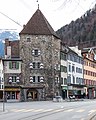
Maltese Tower in Chur

Arcas Square in Chur's old town

New Chur train station with integrated post bus station
Hofquartier (from left to right) Cathedral, Episcopal Palace, Marsöl House, Buolsches Haus and Martinskirche. Bottom right: the Sennhof cantonal penal institution
City administration (main building, moved into in December 2005)

St. Martin's Church Chur


personalities
See also
literature
- Martin Bundi , Ursula Jecklin, Georg Jäger : History of the City of Chur. Part 2. From the 14th to the 17th century (= Historia Raetica. Volume 4,[2]). Calven, Chur 1986, OCLC 256447049 .
- Georges Descœudres, Luzi Dosch: The evangelical parish church of St. Martin in Chur (= Swiss art guide . No. 573, Ser. 58). Published by the Society for Swiss Art History GSK, Bern. In cooperation with the Evangelical parish of Chur. GSK, Berne 1995, ISBN 3-85782-573-1 .
- Ursula Jecklin (Red.): Chur's city history. 2 volumes. Publisher Bündner monthly sheet, Chur 1993, ISBN 3-905241-32-3 and ISBN 3-905241-33-1 .
- Erhard Meier: Chur - city in the pass country. City guide (= cultural routes in Graubünden ). Terra Grischuna Verlag, Chur / Bottmingen / Basel; Tourist Association, Chur 1986, ISBN 3-7298-1040-5 .
- Erhard Meier: Chur - the Alpine city. City-guide. Desertina Verlag, Chur 2008, ISBN 978-3-85637-352-8 .
- Robert von Planta: About the language history of Chur. In: Graubünden monthly sheet . Magazine for Grisons history, regional studies and folklore. April 1931, ISSN 1011-6885 , pp. 97–118, doi:10.5169/seals-396647 .
- Erwin Poeschel : The art monuments of the canton of Graubünden. Volume VII: The city of Chur and the district of the five villages (= art monuments of Switzerland . Volume 20). Published by the Society for Swiss Art History GSK. GSK, Berne 1948; unchanged Nachdr. Birkhäuser, Basel 1975, ISBN 3-7643-0808-7 .
- Jürg Rageth, Anne Hochuli-Gysel, Linus Bühler, Martin Bundi , Jürg Simonett: Chur (municipality). In: Historical Lexicon of Switzerland .
- Christoph Simonett: History of the city of Chur. Part 1. From the beginning to around 1400 (= Historia Raetica. Volume 4). Calven, Chur 1976, OCLC 3312205 ; 1985 2 , OCLC 631928327 .
web links
- Official website of the city of Chur
- World of Castles: Chur city fortifications
- Chur city tour: historical buildings
- Chur on the ETHorama platform
- Federal inventory ISOS: Chur
- Federal Inventory ISOS: Pulvermühle, Federal (Chur)
itemizations
- ↑ FSO Generalized Boundaries 2020 . In later municipality mergers, heights are summarized based on the status as of January 1, 2020. Retrieved May 17, 2021
- ↑ Generalized Boundaries 2020 . In later municipal mergers, areas are combined based on the status as of January 1, 2020. Retrieved May 17, 2021
- ↑ Permanent resident population by citizenship category, sex and municipality, final annual results, 2020 . In the case of later municipal mergers, population figures are summarized based on the status of 2020. Retrieved November 17, 2021
- ↑ Permanent resident population by citizenship category, sex and municipality, final annual results, 2020 . In later municipal mergers, the proportion of foreigners is summarized based on the status of 2020. Retrieved November 17, 2021
- ↑ Original material from the language atlas of German-speaking Switzerland on Sprachatlas.ch.
- ↑ Johann Ulrich Hubschmied: Chur and Churwalhen. In: matter, place and word. Festschrift for Jakob Jud (= Romanica Helvetica. Volume 20). Zurich-Erlenbach / Geneva 1943; Rhaetian name book. Volume 2: Etymologies. edit. and ed. by Andrea Schorta. Francke, Bern 1964, p. 658 f.; Paul Zinsli : Place names. Structures and layers in the names of settlements and fields in German-speaking Switzerland (= writings of the German-Swiss language association. Booklet No. 7). 2nd, through and supplementary edition Huber, Frauenfeld 1975, p. 19; Lexicon of Swiss community names . Edited by the Center de Dialectologie at the University of Neuchâtel under the direction of Andres Kristol. Frauenfeld / Lausanne 2005, p. 247 f.; German place name book. Edited by Manfred Niemeyer. De Gruyter, Berlin / Boston 2012, p. 111 f.
- ↑ Facts & Figures. Did you know... Chur Tourism, retrieved August 10, 2021 .
- ↑ Rüfe Val Parghera. In: valparghera.ch, retrieved on March 7, 2020.
- ↑ Lürlibad District Association. In: quartierverein-luerlibad.ch. Quartierverein in Chur, retrieved on March 18, 2017.
- ↑ Climate standard values Chur. Standard period 1991-2020. (PDF) In: meteoschweiz.admin.ch. Federal Office of Meteorology and Climatology MeteoSwiss, accessed 15 January 2022 .
- ↑ See the self-designation Churs, Chur - the oldest city in Switzerland. In: chur.ch, retrieved on November 14, 2018 ("The history of Chur goes back a long way. 13,000 years ago, Palaeolithic hunters and gatherers lived temporarily in today's urban area. Chur therefore describes itself as the oldest city in Switzerland.").
- ^ Jürg Rageth summarizing the history of research: Chur – Welschdörfli, Schutzbau Areal Ackermann. Prehistoric and Roman finds and findings (= Archaeological Guide of Switzerland. No. 29). Gasser, Chur 1998, pp. 6–10 (overview map on p. 7).
- ↑ AE 1966, 270 ( Illustration of the inscription at Ubi erat lupa ). Description of the inscription in: Christian Witschel : The perception of Augustus in Gaul, in Illyricum and in the northern provinces of the Roman Empire. In: Detlev Kreikenbom et al. (Ed.): Augustus - the view from the outside. The perception of the emperor in the provinces of the empire and in the neighboring states (= royalty, state and society in early high cultures. Volume 8). Harrassowitz, Wiesbaden 2008, ISBN 978-3-447-05715-8 , pp. 41–120, here p. 97 ( preview in Google book search).
- ↑ Anne Hochuli-Gysel: Chur (municipality). 1 – Prehistory and Early History. 1.2 – Roman era. In: Historical Lexicon of Switzerland . 18 November 2015 , retrieved 1 August 2016 .
- ↑ Codex iuris municipalis Germaniae medii aevi. Registers and documents on the constitutional and legal history of German cities in the Middle Ages. First volume. Collected and ed. by Heinrich Gottfried Philipp Gengler . Ferdinand Enke, Erlangen 1863, OCLC 633849160 , pp. 491–494 ( limited preview in Google book search, additions , index ).
- ↑ About Chur. Story. city fire. Chur becomes a guild town. 1464. (No longer available online.) In: chur.de. Archived from the original on July 14, 2017 ; retrieved November 14, 2018 .
- ↑ Dietrich WH Schwarz : The cities of Switzerland in the 15th century . In: Announcements of the Antiquarian Society in Zurich . tape 60 , 1993, p. 227-244 , doi : 10.5169/seals-378993 .
- ↑ City fire 1464. Chur becomes a guild city (exhibition boards). 17 Jan 1465. Chur under the guild constitution 1465–1840. In: chur.ch. Retrieved August 10, 2021 . with web link to the exhibition boards 550 years of Chur guilds ( chur.ch [PDF; 36.3 MB]).
- ↑ Winfried Hecht : The Juliusbanner of the facing place Rottweil. In: The History Friend: Communications from the Historical Association of Central Switzerland. 126/7 (1973/4), pp. 141-150, doi:10.5169/seals-118647 .
- ↑ a b c For the importance of Chur in the history of the Reformation, see the sections Reformation and Thirty Years ' War as well as Religions and the city portrait of the project Cities of the Reformation in Europe: Reformation City of Chur. Switzerland. A special interplay of religion and politics – to this day. In: reformation-cities.org/cities, retrieved on August 1, 2016, as well as the city portrait of the project Europäischer Stationenweg: Chur. In: r2017.org/europaeischer-Stationenweg. Reformation anniversary 2017 e. V., archived from the original on June 29, 2019 ; retrieved 1 August 2016 .
- ↑ Simon Hehli: Tour de Suisse of the Reformation. In: New Zurich newspaper . 4 November 2016, p. 15.
- ↑ Constantin Seibt: Chur - city of hunting, drinkers and dreams. (No longer available online.) In: Tages-Anzeiger . October 4, 2006, archived from the original on January 7, 2008 ; retrieved November 14, 2018 .
- ↑ Hans Marti - pioneer of spatial planning (= documents on modern Swiss architecture ). Edited by Claude Ruedin, Michael Hanak. GTA, Zurich 2008, ISBN 978-3-85676-236-0 (collection of essays).
- ↑ Chronicle. December [1972]. In: Graubünden monthly sheet . Issue 3–4, 1973, p. 90, doi:10.5169/seals-398131 (as of December 15, 1972; PDF; 3.9 MB).
- ↑ See resident population statistics of the city of Chur. (PDF; 63 kB) (No longer available online.) In: chur.ch. January 14, 2016, archived from the original on March 30, 2016 ; retrieved November 14, 2018 .
- ↑ Chur in numbers. (No longer available online.) In: chur.ch. Formerly in the original ; Retrieved January 14, 2017 (for 2016). ( Page no longer available , search in web archives ) Facts & Figures. (No longer available online.) In: chur.graubuenden.ch. Archived from the original on August 12, 2018 ; Retrieved March 26, 2018 (for 2017).
- ↑ Resident population on December 31, 2016. (PDF; 90 kB) City of Chur, January 6, 2017, retrieved on June 28, 2017 .
- ↑ Oscar Eckhardt: Something Churer German language history - from Latin to Alemannic (= Khuurer Worttrugga. 8). In: Chur magazine. [O. D. (June 2008)], p. 25 ( churermagazin.ch [PDF; 499 kB; retrieved on August 6, 2016]; "Roman exhibition in Chur: Where the Romans were, Latin was also spoken. Chur has only been around for about 500 years German-speaking.»).
- ↑ Bürgergemeinde Chur: The development of citizenship (2001–2010) ( memento of November 8, 2011 in the Internet Archive ). In: buergergemeinde-chur.ch, retrieved on July 31, 2016.
- ↑ Chur in numbers. Accessed January 1, 2021, accessed August 10, 2021.
- ↑ Chur in numbers. As of January 1, 2020. In: chur.ch. Archived from the original on June 30, 2020 ; retrieved March 7, 2020 .
- ↑ Federal Statistical Office FSO: Resident population by religion, by canton and city ( memento of December 29, 2008 in the Internet Archive ). In: bfs.admin.ch, retrieved on April 11, 2011.
- ↑ The coat of arms of Chur. In: chur.de, retrieved on January 14, 2017.
- ↑ Federal Statistical Office : NR – results of parties (municipalities) (INT1). (CSV) In: Federal elections 2019 | opendata.swiss. August 8, 2019, archived from the original on August 11, 2020 ; retrieved 1 August 2020 .
- ↑ Twin Cities . City of Chur, retrieved January 16, 2015 . See the special partnership website Partnerschaftsring – Jumelage. In: partnershipsring.eu, retrieved on July 31, 2016.
- ^ City of Chur (ed.): Welcome to Chur. City of Chur, Chur 2014, DNB 1070796115 , p. 42.
- ↑ Hans Georg Wehrens: The dance of death in the Alemannic language area. "I need it - and I don't know when". Schnell & Steiner, Regensburg 2012, ISBN 978-3-7954-2563-0 , p. 150 f.
- ↑ Kantonsbibliothek Graubünden: Gray House or New Building (= stately homes and villas ). In: graubuendenkultur.ch, retrieved on July 31, 2016.
- ↑ Léa Burger: New Cathedral Treasury Museum in Chur. Audio contribution Blickpunkt Religion on srf.ch , from August 30, 2020. Retrieved on March 4, 2021.
- ↑ Graubünden Canton Library: Former Church of St. Stephen (= early Christian period ). In: graubuendenkultur.ch, retrieved on July 31, 2016.
- ^ Graubünden Canton Library: Church of the Redeemer (= contemporary architecture ). In: graubuendenkultur.ch, retrieved on July 31, 2016.
- ↑ Luzi Dosch (co-author): The Holy Cross Church in Chur (= Schweizerische Kunstführer. No. 451, Ser. 46). Published by the Society for Swiss Art History GSK in cooperation with the parish office of Heiligkreuz. GSK, Berne 1989, ISBN 3-85782-451-4 .
- ↑ Graubünden Canton Library: Catholic Heiligkreuzkirche (= Modern ). In: graubuendenkultur.ch, retrieved on July 31, 2016.
- ↑ Kantonsbibliothek Graubünden: Domdekanat (= other buildings and works ). In: graubuendenkultur.ch, retrieved on July 31, 2016.
- ↑ Kantonsbibliothek Graubünden: Dompropstei (= other buildings and works ). In: graubuendenkultur.ch, retrieved on July 31, 2016.
- ^ Graubünden Canton Library: Former Dominican monastery of St. Nicolai (= other buildings and works ). In: graubuendenkultur.ch, retrieved on July 31, 2016.
- ↑ Graubünden Cantonal Library: Train station, square and post bus hall, 2009 (= contemporary architecture ). In: graubuendenkultur.ch, retrieved on July 31, 2016.
- ↑ Kantonsbibliothek Graubünden: Former Graubünden teacher training college (= modern ). In: graubuendenkultur.ch, retrieved on July 31, 2016.
- ^ Graubünden Canton Library: Daleu Cemetery (= squares, gardens and parks ). In: graubuendenkultur.ch, retrieved on July 31, 2016.
- ↑ Kantonsbibliothek Graubünden: Commercial vocational school (= modern ). In: graubuendenkultur.ch, retrieved on July 31, 2016.
- ↑ Kantonsbibliothek Graubünden: Graubündner Kantonalbank (= regionalism ). In: graubuendenkultur.ch, retrieved on July 31, 2016.
- ↑ Graubünden Cantonal Library: Expansion of the Graubündner Kantonalbank headquarters, 2006 (= contemporary architecture ). In: graubuendenkultur.ch, retrieved on July 31, 2016.
- ↑ Graubünden Cantonal Library: University of Technology and Economics, 1993 (= contemporary architecture ). In: graubuendenkultur.ch, retrieved on July 31, 2016.
- ↑ Kantonsbibliothek Graubünden: Konvikt der Bündner Kantonsschule (= Modern ). In: graubuendenkultur.ch, retrieved on July 31, 2016.
- ↑ Graubünden Canton Library: House for Natural Sciences, Canton School, 1999 (= contemporary architecture ). In: graubuendenkultur.ch, retrieved on July 31, 2016.
- ^ Graubünden Canton Library: Marsölturm (= castles and towers ). In: graubuendenkultur.ch, retrieved on July 31, 2016.
- ^ Graubünden Canton Library: Martinsbrunnen (= small architecture ). In: graubuendenkultur.ch, retrieved on July 31, 2016.
- ↑ Graubünden Canton Library: media and administration building Untertor, 2006 (= contemporary architecture ). In: graubuendenkultur.ch, retrieved on July 31, 2016.
- ^ Graubünden cantonal library: Obertor (= castles and towers ). In: graubuendenkultur.ch, retrieved on July 31, 2016.
- ↑ Graubünden Canton Library: Powder Tower, so-called Maltese Tower (= castles and towers ). In: graubuendenkultur.ch, retrieved on July 31, 2016.
- ↑ Graubünden cantonal library: Quader school building (= regionalism ). In: graubuendenkultur.ch, retrieved on July 31, 2016.
- ^ Graubünden Canton Library: Red Tower (= other buildings and works ). In: graubuendenkultur.ch, retrieved on August 1, 2016.
- ↑ Kantonsbibliothek Graubünden: state building (= other buildings and works ). In: graubuendenkultur.ch, retrieved on August 1, 2016.
- ↑ Graubünden cantonal library: Gate building (= small architecture ). In: graubuendenkultur.ch, retrieved on August 1, 2016.
- ↑ Kantonsbibliothek Graubünden: Torturm (= castles and towers ). In: graubuendenkultur.ch, retrieved on August 1, 2016.
- ^ Graubünden Canton Library: Würth administration building (= contemporary architecture ). In: graubuendenkultur.ch, retrieved on August 1, 2016.
- ↑ Graubünden Canton Library: Bettenhaus D (= contemporary architecture ). In: graubuendenkultur.ch, retrieved on August 1, 2016.
- ↑ Kantonsbibliothek Graubünden: Bondahaus (= regionalism ). In: graubuendenkultur.ch, retrieved on August 1, 2016.
- ↑ Graubünden Canton Library: Former Brandis House (= stately homes and villas ). In: graubuendenkultur.ch, retrieved on August 1, 2016.
- ↑ Graubünden Cantonal Library: Former residential building Schäfer & Risch (= regionalism ). In: graubuendenkultur.ch, retrieved on August 1, 2016.
- ↑ Graubünden Canton Library: Single-family house (= modern ). In: graubuendenkultur.ch, retrieved on August 1, 2016.
- ↑ Graubünden Canton Library: Single-family house Sieber-Cafaro (= contemporary architecture ). In: graubuendenkultur.ch, retrieved on August 1, 2016.
- ↑ Kantonsbibliothek Graubünden: Haldenhof (= regionalism ). In: graubuendenkultur.ch, retrieved on August 1, 2016.
- ↑ Graubünden Canton Library: House 'to the sea port' (= late Gothic ). In: graubuendenkultur.ch, retrieved on August 1, 2016.
- ↑ Graubünden Canton Library: House of the town clerk Otto von Schwartz (= stately homes and villas ). In: graubuendenkultur.ch, retrieved on August 1, 2016.
- ^ Graubünden Canton Library: House Gartmann (= contemporary architecture ). In: graubuendenkultur.ch, retrieved on August 1, 2016.
- ↑ Graubünden Canton Library: Haus Schwartz auf dem Sand (= stately homes and villas ). In: graubuendenkultur.ch, retrieved on August 1, 2016.
- ↑ Graubünden Canton Library: House Zinsli (= Modern ). In: graubuendenkultur.ch, retrieved on August 1, 2016.
- ↑ Graubünden Canton Library: Haus zum Brunnengarten (= stately homes and villas ). In: graubuendenkultur.ch, retrieved on August 1, 2016.
- ↑ Graubünden Canton Library: Haus zur Linde (= stately homes and villas ). In: graubuendenkultur.ch, retrieved on August 1, 2016.
- ↑ Kantonsbibliothek Graubünden: Laubenhof (= regionalism ). In: graubuendenkultur.ch, retrieved on August 1, 2016.
- ↑ Kantonsbibliothek Graubünden: Massnerhäuser (= stately homes and villas ). In: graubuendenkultur.ch, retrieved on August 1, 2016.
- ^ Graubünden Canton Library: Mühlbach-Bar (= contemporary architecture ). In: graubuendenkultur.ch, retrieved on August 1, 2016.
- ↑ Kantonsbibliothek Graubünden: Schniderzunft (= other buildings and works ). In: graubuendenkultur.ch, retrieved on August 1, 2016.
- ^ Graubünden Canton Library: Stampagarten settlement (= settlement construction ). In: graubuendenkultur.ch, retrieved on August 1, 2016.
- ↑ Kantonsbibliothek Graubünden: Villa Fontana (= stately homes and villas ). In: graubuendenkultur.ch, retrieved on August 1, 2016.
-
↑ Luzi Dosch: Villa Planta/Bündner Kunstmuseum Chur (= Swiss art guide. No. 482). Published by Society for Swiss Art History GSK. Berne 1991, ISBN 3-85782-482-4 . –
Graubünden Canton Library: Villa Planta (= stately homes and villas ). In: graubuendenkultur.ch, retrieved on August 1, 2016. - ↑ Kantonsbibliothek Graubünden: Villa zur Heimat (= stately homes and villas ). In: graubuendenkultur.ch, retrieved on August 1, 2016.
- ↑ Graubünden Cantonal Library: Residential and commercial building Urech (= modern ). In: graubuendenkultur.ch, retrieved on August 1, 2016.
- ↑ Graubünden Canton Library: residential and commercial building (= contemporary architecture ). In: graubuendenkultur.ch, retrieved on August 1, 2016.
- ↑ Kantonsbibliothek Graubünden: residential building (= other buildings and works ). In: graubuendenkultur.ch, retrieved on August 1, 2016.
- ↑ Graubünden Canton Library: Residential building in Bavier (= regionalism ). In: graubuendenkultur.ch, retrieved on August 1, 2016.
- ↑ Graubünden Canton Library: Bearth residential building (= contemporary architecture ). In: graubuendenkultur.ch, retrieved on August 1, 2016.
- ↑ Graubünden Canton Library: Conrad residential building (= contemporary architecture ). In: graubuendenkultur.ch, retrieved on August 1, 2016.
- ↑ Graubünden Canton Library: House for the elderly, 1993 (= contemporary architecture ). In: graubuendenkultur.ch, retrieved on August 1, 2016.
- ↑ Tusculum settlement in Böschengut, Chur. In: arc-award.ch. Retrieved April 9, 2021 (German, French).
- ↑ David Freshness: Chur experienced a great moment. Chur is now also represented in space: Yesterday, the Graubünden Astronomical Society officially dedicated the asteroid it discovered two years ago to the city. In: Southeastern Switzerland . October 27, 2011, accessed July 31, 2016.
Remarks
- ↑ Reopening after extensive renovation in March 2021.
AG : Aarau | AR : Herisau / Trogen | AI : Appenzell | BL : Liestal | BS : Basle | BE : Berne | FR : Friborg | GE : Geneva | GL : Glarus | GR : Chur | JU : Delsberg | LU : Lucerne | NE : Neuchâtel | NW : Stans | OW : Sarnen | SH : Schaffhausen | SZ : Schwyz | SO : Solothurn | SG : St Gallen | TI : Bellinzona | TG : Frauenfeld | Ur : Altdorf | VD : Lausanne | VS : manners | ZG : Train | ZH : Zurich
Arosa | Chur | Churwalden | Tschiertschen-Praden
Former communities: Calfreisen | Castiel | Haldenstein | Hof Chur | Langwies | Luen | Maladers | Malix | Molini's | Pagig | Parpan | Peist | Praden | St. Peter Pagig | Saint Peter | Tschiertschen
Canton Graubünden | Regions of the Canton of Graubünden | Municipalities in the canton of Graubünden