
Montalin
| Montalin | ||
|---|---|---|
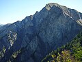
 The rock towers to the Montalin above the city of Chur, the white peak is the Montalin |
||
| height | 2266 m above sea level M. | |
| location | Canton of Graubünden , Switzerland | |
| Mountains | Graubünden Alps | |
| Dominance | 1.26 km → Ful Berg | |
| Notch height | 100 m ↓ Scharte to Gromser Chopf | |
| Coordinates | 764 056 / 192 536 | |
|
||
| Type | Mountains | |
 Map: Chur with Montalin ENE |
||
 Path south of the summit with a view of Chur with the Calanda on the right. |
||

The Montalin is a mountain peak in the Graubünden Rhine Valley , in the northern part of the canton of Graubünden , northeast above the city of Chur . The mountain range bounded in the northwest by the Chur Rhine Valley and in the south by the Schanfigg includes the Vorgipfel Fürhörnli , 1888 m, the Ful Berg 2391 m and the Hochwang 2533 m. The summit belongs to the municipality of Trimmis and Arosa (formerly Calfreisen ), a point about 45 meters below that also reaches the municipality of Maladers .
geography
The mountain ridge of the Montalin is mostly grass-covered towards the south (the word Wang denotes such a steep grass slope), while the north-west slope is made up of countless rock peaks. The upswing from Chur (650 m) reaches the Mittenberg at 1101 m, a self-explanatory name. The Fürhörnli in the further course at 1888 m is considered the highest point in the city of Chur. This region is signposted as a nature reserve. Ibex are native to the undisturbed northern slope of the Montalin.
The rock is brittle, so that the vegetation remains sparse on the steep north side, which is evident in the numerous bare ravines and crevices that reach down to the bottom of the Rhine valley; the Trimmiser Rüfe has also recently flooded the motorway in the valley floor.
According to a foreign division into two, the Montalin belongs to the western Eastern Alps . In Wikipedia you can still find the subdivision Plessur-Alpen . As you can see from the discussions on Wikipedia, this classification is not fully accepted in Germany either. An internationally recognized division of the Alps into subgroups is still not available and is not to be expected in the foreseeable future. Almost every Alpine country divides the Alps differently. The borderline of the Rhine Valley and the continuation to the Splügen Pass and Lake Como as the beginning of the Eastern Alps is common. With the three-part division of the Western, Central and Eastern Alps, the areas up to the Brenner, including Eastern Grisons, would be in the Central Alps (Attention: in Austria the Austrian Alps are the Central Alps .... (= geographical term)).
geology
Geologically, the Montalin belongs to the Pennine Nappes (Mesozoic and Old Tertiary sediments) which in this area mainly consist of Mesozoic sediments (Jurassic period), and therefore of Bündner slate . So this as a clear demarcation from the Calanda , which is located near Chur on the opposite side of the valley and belongs to the Parautochton.
Approach
The Montalin should actually be tackled from Chur (660 m) via Mittenberg so that you can feel the entire 1600 meters of altitude. The Postbus brings some relief to Maladers, where the path starts at a good 1000 meters and joins the Chur approach at 1615 m.
If you get on from this side, after the Fürhörnli you will reach a blue and white marked path, which requires mountain experience.
If you choose the Schanfigger Höhenweg from Maladers , you can turn north on the Maiensäss via Calfreisen and reach the summit on a red and white marked mountain hiking trail .
From the north, the Montalin can be reached from Trimmis via the Fürstenalp.
Panoramas


photos
The Montalin seen from the Fürhörnli, point 1888 m.

Montalin: View to the north into the Rhine Valley, striking in the background to the left of the center of the Falknis , highest point on the horizon Schesaplana
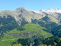
The Montalin via Calfreisen in Schanfigg

Ibex on the hiking trail to the Montalin


source
- Manfred Hunziker: Ringelspitz / Arosa / Rätikon , Alpine Touren / Bündner Alpen , Verlag des SAC 2010, ISBN 978-3-85902-313-0 , p. 446.
Web links
- [1] Tour reports and photos