
Trimmis
| Trimmis | |
|---|---|
 |
|
| State : |
|
| Canton : |
|
| Region : | Landquart |
| BFS no. : | 3945 |
| Postal code : | 7202 Says 7203 Trimmis |
| UN / LOCODE : | CH TRS |
| Coordinates : | 761 975 / 196 083 |
| Height : | 637 m above sea level M. |
| Height range : | 529-2532 m above sea level M. |
| Area : | 42.87 km² |
| Residents: | 3304 (December 31, 2018) |
| Population density : | 77 inhabitants per km² |
| Website: | www.trimmis.ch |
 Trimmis |
|
| Location of the municipality | |
  |
|
Trimmis ( Rhaeto-Romanic ) is a municipality in the Landquart region of the canton of Graubünden in Switzerland . The village of Says has also been part of the municipality since January 1st, 2008.
The film It happened in broad daylight was shot in Trimmis in 1958 , based on the script by Friedrich Dürrenmatt with Gert Fröbe and Heinz Rühmann in the leading roles.
geography
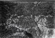
Trimmis is 6 km north of the canton capital Chur on the right side of the Rhine , which flows by just 2 km west of the village center. In 1880, when Says was separated from Trimmis and made an independent municipality (merged again on January 1, 2008), the shape of the municipality ban was created with two spatially separated parts. The larger stretched from the Rhine over the slope furrowed by several gorges such as the Scaläratobel to the western foothills of the Hochwang range . With the striking mountains Cyprianspitz ( 1774 m above sea level ) in the north, Ful Berg (2395 m) and Montalin (2266 m) in the south, the area reaches the ridge, with the Sayser area roughly delimited by Hagtobel and Valturtobel in between. In the rear Valzeinatal, on the right side of the Schranggabach , was an exclave . There the Hochwang summit (2533 m) marks the highest point in the community.
At the exit of the Valturtobel, on both sides of the Dorfrüfe , is the clustered village of Trimmis. In the 20th century, the settlement grew mainly to the west, where the main road passes around 1 km away. The Ceres / Rütenen industrial zone at the Untervaz train station also belongs to the municipality .
In 1997, 34.4% of the municipal area was used for agriculture, the forest took up 41.5%, the settlements 4.7%. 19.5% were considered unproductive.
Neighboring communities are Arosa , the city of Chur , Furna , Grüsch , Haldenstein , Untervaz , Valzeina and Zizers .
coat of arms
Blazon : In silver (white) over a green Dreispitzberg two rooted black ibex horns lying across to the right
The horns come from the coat of arms of the Lords of Trimmis, the mountain alludes to the folk etymology , which leads the place name back to Trimons (three mountain).
history
Tremune was first mentioned in documents in 765 in the will of Bishop Tello , when a church already existed. The rare patronage of St. Carpophorus is also attested from that time. In the late Middle Ages, the village belonged to the episcopal rule Alt-Aspermont, named after the Alt-Aspermont castle at the exit of the Hagtobel, then from 1519 to the High Court of Four Villages of the Church of God . The ruins of Ober-Ruchenberg Castle are located high above the village .
Both denominations have been represented in the community since the 17th century. In 1880, Says was split off from Trimmis and formed an independent community until 2007. On January 1, 2008, the two communities were reunited.
During the Second World War , the Trimmis barrier was created north of Trimmis . Together with the Untervaz blocking point, it formed the southern front of the Sargans fortress .
population
| Population development | ||||||||
|---|---|---|---|---|---|---|---|---|
| year | 1770 | 1880 | 1900 | 1950 | 1980 | 2005 | 2015 | 2018 |
| population | 587 | 888 | 696 | 776 | 1447 | 2881 | 3191 | 3225 |
politics
The community board has five members. The current mayor is Roman Hug (as of 2019). There is a community partnership with Weyregg am Attersee in Austria.
economy
While viticulture and agriculture used to be the main livelihoods, Trimmis has developed into a popular residential community on the outskirts of the canton's capital since 1950. The population has almost quadrupled in 50 years. However, the community also succeeded in relocating a number of businesses, so that 477 people can find work in the commercial sector on site. There are 65 employees in agriculture and forestry and 276 in the service sector (as of 2000–01).
traffic
The city bus route 3 Chur – Trimmis – Untervaz, which is operated every half hour during the day, connects the community to the public transport network. On the other hand, the Trimmis stop of the Rhaetian Railway , which is 1.5 km from the village center and therefore less frequented , was canceled when the timetable changed in December 2006.
Attractions
The Catholic parish church and the Reformed village church are listed as historical monuments .
Personalities
- Bartholomäus Anhorn the Elder (1566–1642), Protestant Reformed pastor and historian in Graubünden and Appenzell, in Trimmis 1614
Community merger
A project group set up in 2003 came to the conclusion that a merger between the municipalities of Trimmis and Says ... represents the right future-oriented step . On April 26, 2005, both community boards agreed to this recommendation. On May 8, 2007, both community assemblies approved the merger with a large majority. On June 17, 2007, the urn community in Trimmis also approved the merger.
literature
- Erwin Poeschel : The Art Monuments of the Canton of Graubünden, Volume VII: The City of Chur and the Circle of Five Villages. (= Art Monuments of Switzerland. Volume 20). Edited by the Society for Swiss Art History GSK. Bern 1948, DNB 760079668 .
Web links
- Official website of the municipality of Trimmis
- Adolf Collenberg: Trimmis. In: Historical Lexicon of Switzerland .
Individual evidence
- ↑ Permanent and non-permanent resident population by year, canton, district, municipality, population type and gender (permanent resident population). In: bfs. admin.ch . Federal Statistical Office (FSO), August 31, 2019, accessed on December 22, 2019 .
- ↑ NZZ
Bottle | Jenins | Landquart | Maienfeld | Malans | Trimmis | Untervaz | Zizers
Former municipalities: Igis | Mastrils | Says
Canton of Graubünden | Regions of the Canton of Graubünden | Municipalities of the Canton of Graubünden