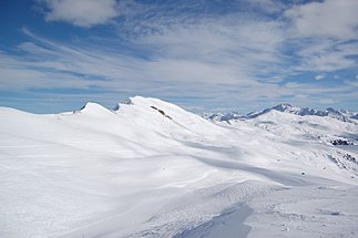
Hochwangkette
| Hochwangkette | ||
|---|---|---|
|
Hochwang seen from the west |
||
| Highest peak | Hochwang ( 2535 m above sea level ) | |
| location | Graubünden , Switzerland | |
| part of | Plessur Alps | |
|
|
||
| Coordinates | 767 208 / 193 724 | |
The Hochwangkette is a mountain range in the Plessur Alps in the Swiss canton of Graubünden .
Extension and summit
The chain extends east of the Rhine Valley from Chur in the west to the Durannapass in the east.
The highest elevation of the mountain group consisting of slate is the namesake Hochwang with 2533 m above sea level. Other peaks are the Montalin (2266 m), Ful Berg (2391 m), Tüfelsch Chopf (2480 m), Ratoser Stein (2474 m), Cunggel (2413 m), Glattwang (2376 m), Mattjischhorn (2461 m) and Chistenstein (2473 m)
Limitation
Landquart - Prättigau to Conters - Durannapass - Fondei - Schanfigg - Chur Rhine Valley - Landquart.
Overview
The Hochwangkette separates the Schanfigg with the Fondei from the Prättigau. The ridge runs from west (Chur) to east (Durannapass) with a few changes in direction, but with only minor differences in altitude. Hardly any culmination is more than 200 m above the neighboring depression. A fact of walking the tightrope very favored. There is extensive alpine terrain on both sides of the ridge. On the Schanfigg side it is only structured by the south ridge of the Mattjischhorn, which runs over the Blackter Flue to Langwies. Three distinctive chains branch off to the north. The most westerly from the Ful mountain to the Prättigauer Chlus, with rugged flanks against the Rhine valley. The second from Hochwang to Furner-Berg. The third from the Arflinafurgga over the Glattwang to Jenaz.
Mountain hikers have numerous opportunities for ascents and tours or any hike from alp to alp. There are hardly any difficult routes reserved for alpinists in this area. The area east of the Hochwangs is suitable for (touring) skiing; the number of transport systems (which are only in operation in winter) is limited. The Schanfigg Höhenweg, created by Schanfigg Tourismus, also runs along the southern slope.
Starting points
All peaks can be easily reached from the valleys on both sides. Easier from the villages of Schanfigg, which are several hundred meters higher and several kilometers closer to the ridge than the villages of Prättigau. Various forest and alpine roads that are pleasant to walk up to around 1900 m lead from both valleys.
cards
- National map of Switzerland 1: 25,000, sheet 1176 Schiers , sheet 1177 Serneus , sheet 1196 Arosa , sheet 1197 Davos .
- National map of Switzerland 1: 50,000, sheet 248 Prättigau .
literature
- Manfred Hunziker: Ringelspitz / Arosa / Rätikon , Alpine Touren / Bündner Alpen , Verlag des SAC 2010, ISBN 978-3-85902-313-0 , p. 414 ff.
- Manfred Hunziker: Bündner Alps. Volume 1: Tamina and Plessur Mountains. 4th edition. Swiss Alpine Club , Bern 1988, ISBN 3-85902-048-X .

