
Furna GR
| GR is the abbreviation for the canton of Graubünden in Switzerland and is used to avoid confusion with other entries of the name Furna . |
| Furna | |
|---|---|
 |
|
| State : |
|
| Canton : |
|
| Region : | Prättigau / Davos |
| BFS no. : | 3862 |
| Postal code : | 7232 |
| Coordinates : | 769 644 / 200435 |
| Height : | 1351 m above sea level M. |
| Height range : | 765-2532 m above sea level M. |
| Area : | 33.32 km² |
| Residents: | 221 (December 31, 2018) |
| Population density : | 7 inhabitants per km² |
| Website: | www.furna.ch |
 Furna GR |
|
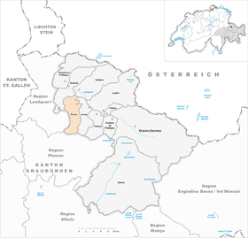
| Location of the municipality | |
  |
|
Furna (in the Walser German local dialect Furnä [furnæ, furnɐ] , Rhaeto-Romanic ) is a political municipality in the Prättigau / Davos region of the canton of Graubünden in Switzerland .
geography
The scattered settlement Furna is located in the central Prättigau on the eastern slope of the Furner Berg ( 1824 m above sea level ). The extensive territory essentially comprises the left side of the valley of the Furner Bach , an approximately 10 km long left tributary of the Landquart . In the south the valley is closed by the Hochwang chain , the most striking peaks are the Hochwang (2533 m, highest point in the municipality) and the Cunggel (2413 m). The western boundary runs first on the gentle ridge running north from the Hochwang to the Wannenspitz (1970 m) and then in irregular up and down north-west around the Furner Berg. In the east, the area extends to the deeply incised, pathless ravine of the Furner Bach.
The settlements are concentrated in the groups Usserberg , Mittelberg and Hinterberg . There are also numerous individual farms.
Neighboring communities are Arosa , Grüsch , Jenaz , Schiers and Trimmis (until December 31, 2007 as exclave, after merging with Says directly).
history
The village was first mentioned in a document in 1479 as a furnen . In the 14th and 15th centuries, Walsers immigrated to the area, which was previously sparsely populated by Romans . As part of the Castels court, the place belonged to the Three Leagues of the Ten Courts League.
On September 13, 1931, the Furner elected a pastor and caused a sensation throughout Switzerland. The election of the first female pastor in Europe was carried out against the regulations of the cantonal regional church and promptly the cantonal church authorities confiscated the church property.
Furna was electrified in 1968 - as the last village in the canton of Graubünden and one of the last villages in Switzerland. In the Prättigau in particular, jokes were made about the Furner and their backwardness.
coat of arms
Blazon : A golden crescent moon rising in blue, raised by two crossed golden arrows with a silver ray .
The arrows from the coat of arms of the Sprecher family are combined with the moon, which occurs frequently in the Walser family coat of arms . Colors of the Ten Court League.
population
| Population development | ||||||
|---|---|---|---|---|---|---|
| year | 1850 | 1900 | 1950 | 1990 | 2008 | |
| population | 216 | 209 | 222 | 211 | 214 | |
Transport and economy
The rural community has been developed with a road since 1879. In 1889 the Landquart – Klosters ( Rhaetian Railway ) line was opened with the Furna stop in the Jenaz municipality, and in 1936 a post bus connection was set up between the station and the village.
Furna strives for development in the sense of gentle tourism . There are several mountain inns and a variety of hiking and mountain biking opportunities . A large part of the Grüsch-Danusa winter sports area is located in the Furner area.
Attractions
The reformed village church is a listed building .

literature
- Otto Clavuot: Furna. In: Historical Lexicon of Switzerland .
- Erwin Poeschel : The art monuments of the canton of Graubünden II. The valley communities Herrschaft, Prättigau, Davos, Schanfigg, Churwalden, Albula valley. (= Art Monuments of Switzerland. Volume 9). Edited by the Society for Swiss Art History GSK. Bern 1937. DNB 811066703 .
Web links
Individual evidence
- ↑ Permanent and non-permanent resident population by year, canton, district, municipality, population type and gender (permanent resident population). In: bfs. admin.ch . Federal Statistical Office (FSO), August 31, 2019, accessed on December 22, 2019 .
- ^ Linguistic Atlas of German-speaking Switzerland , Volume V, 1b.
- ^ The first female pastor in Europe worked in a village in Prättigau , SRF Kultur, November 23, 2015
- ↑ Archived copy ( Memento of the original from December 17, 2013 in the Internet Archive ) Info: The archive link was inserted automatically and has not yet been checked. Please check the original and archive link according to the instructions and then remove this notice.
Conters in the Prättigau | Davos | Fideris | Furna | Grüsch | Jenaz | Klosters-Serneus | Küblis | Luzein | Schiers | Seewis in the Prättigau
Former parishes: Buchen | Cavadura | Fanas | Hintervalzeina | Monastery | Pany | Plaster | Saas im Prättigau | Schuders | Serneus | St. Antönien | St. Antönien Ascharina | St. Antönien-Castels | St. Antönien Rüti | Valzeina | Vordervalzeina
Canton of Graubünden | Regions of the Canton of Graubünden | Municipalities of the Canton of Graubünden