
Luzein
| Luzein | |
|---|---|
 |
|
| State : |
|
| Canton : |
|
| Region : | Prättigau / Davos |
| BFS no. : | 3891 |
| Postal code : | 7223 Buchen 7224 Putz 7242 Luzein 7243 Pany 7245 St. Antönien Ascharina 7246 St. Antönien-Castels 7246 St. Antönien Rüti 7246 St. Antönien |
| Coordinates : | 777.3 thousand / 199 175 |
| Height : | 958 m above sea level M. |
| Height range : | 685–2824 m above sea level M. |
| Area : | 83.88 km² |
| Residents: | 1582 (December 31, 2018) |
| Population density : | 19 inhabitants per km² |
| Website: | www.luzein.ch |
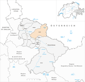
 Luzein |
|
| Location of the municipality | |
  |
|
Luzein , in the highest Alemannic local dialect [lɐˈtsæˑɪ, lɐˈtsæˑɪn] , is a political municipality in the Prättigau / Davos region , in the Swiss canton of Graubünden .
On January 1, 2016 , the former political municipality of St. Antönien , which had already merged in 2007, merged with Luzein and forms part of the municipality. Details on the districts can be found there.
coat of arms
Blazon : oblique left divided by blue and gold, in blue a rising golden arrow, in gold half a blue flight.
In addition to the half-flight (wing) of the Barons von Matsch , the arrow reminds of the Speaker von Bernegg family, who were important for Luzein .
history
Finds of Roman coins with the image of Emperor Constantine I (240–306) near the stadium fortress are the oldest references to residents or travelers. Between 1101 and 1200, Luzein is mentioned as Lucen, Licines, Lucins, 1185 as Luzene and 1411 Pany as Pynnuew . The meaning of the name Luzein is still unclear. In the 12th century the Chur cathedral chapter had possessions in Luzein, which fell to the barons of Vaz in the 13th century . They gave these away to the Premonstratensian Monastery of St. Jakob in Klosters . In Pany there was a castle site by the hamlet of Rosenberg with small finds from the 13th to 15th centuries. On the church hill of Luzein stood the stadium castle, which was already in ruins in 1550. From the castle Castels near Putz, the noble families entitled to rule held office from the 12th century to 1649.
At the time of the Rhaetian Free State of the Three Leagues , Pany, Luzein, Buchen and Putz were attached to the Ten Court Association as part of the High Court of Castels in 1436. This included the ten dishes in the Prättigau , Landwasser and Schanfigg valleys . During this time the residents were largely independent, without a landlord and without feudal burdens. In 1622 there was the great Prättigau war against the Austrians (Habsburgs). After the Prättigauer were able to buy themselves out of Austrian rule after several defeats against the Habsburgs in 1649, the castle of Castels was given up. In 1662 the high court was divided into the judicial communities Castels-Luzein and Castels-Jenaz. From the 15th to the beginning of the 16th century, the Rhaeto-Romanic population in Luzein was Germanized under the influence of the Walsers who immigrated from Davos .
In 1799 the Austrians under General von Hotze marched from the Schruns area over the passes near St. Antönien during the French Wars and invaded the Prättigau via Luzein.
In 1803, after Graubünden entered the Confederation as a canton, the four municipalities became independent. In 1892 the four parishes decided to reunite under what is now the parish of Luzein. There have never been boundary stones that visibly separated the four communities from one another.
Until the middle of the 20th century, livestock and agriculture were practiced in Luzein for self-sufficiency, and after that, cooperative agriculture continued to occupy a strong position. St. Antönienstrasse was built in 1895–99. Tourism developed in the 20th century and in 1927 the Küblis – Pany mountain mail route was established. In 1930 Pany got an open-air swimming pool.
During the Second World War , the main blocking point Fröschenei - Gadenstätt - Chrüz - Stelserberg was set up in Luzein-Boden from 1940 in order to prevent any possible bypassing of the Sargans fortress via the passes at St. Antönien. A total of twelve well camouflaged shelters and bunkers were built for the lock. A military cable car led to the eastern foot of the Chrüz summit .
Ski lifts were built in 1955 and 1973 and around 130 holiday homes between 1958 and 1988. The central school (primary and secondary level) of the Luzein municipality has been located in Pany since 1968.
geography


The community lies on the right-hand slope of the middle Prättigau and consists of the four fractions of Buchen with the hamlets of Lunden and Stels, Luzein with the hamlet of Dalvazza, Pany with the hamlet of Gadenstätt and Putz .
The area extends around the Chrüz mountain , a foothill of the Rätikon , which is 2196 m above sea level. M. marks the highest point of the municipality. In the east, the Schanielabach forms the border, in the south and southwest over long stretches the Landquart , which is only crossed with a small area in the south-east. In the northwest territory extends to the mouth of the book Erbach and beyond Buchner ravine on the Stelserberg with the Stelsersee (nature reserve) down into the headwaters of the Threaded .
In the valley floor on the right bank of the Landquart, separated from the neighboring municipality of Küblis by the Schanielabach which flows here , lies the district of Dalfazza (801 m above sea level). To the north of it, on the slope that rises evenly towards Chrüz, are the districts of Luzein (958 m) and Pany (1249 m), both scattered settlements with densities in the area of the church. To the west of it, high above the valley of the Putzerstein, is the hamlet of Putz (1065 m), and to the north-west is Buchen (950 m) with Hinterlunden (796 m). On the road from Pany to St. Antönien is the district of Gadenstätt (1355 m).
Of the entire municipal area of over 31 km², 1473 hectares are covered by forest and wood. At least 1323 hectares can be used for agriculture. Of the rest, 271 ha are unproductive area (mostly mountains) and 96 ha are settlement areas.
Neighboring communities are Küblis , Conters im Prättigau , Fideris , Jenaz , Schiers and Klosters-Serneus .
population
Of the 1152 residents at the end of 2004, 1119 (= 97%) were Swiss citizens. The majority of the inhabitants belong to the Evangelical Reformed Church in Graubünden .


Economy and Transport
Most of the community's settlements are rural. The trade, including a larger wood processing company, is concentrated in the Dalfazza district.
The tourist center is Pany with a swimming pool, hiking and mountain bike routes, ski lift and toboggan runs.
Luzein is by the post bus lines connected Schiers-Pany and Kueblis-Pany-St.Antönien to the network of public transport.
Attractions
- The reformed church in the district of Luzein is a uniform late Gothic building from the end of the 15th century.
- The village church in Pany was built at the beginning of the 18th century.
- In the seven (according to other counting six or eight) houses of the family spokesman von Bernegg , mostly from the 17th century, rural and aristocratic building forms mix. Site of national importance .
- House speaker on Landgemeindeplatz
- The big house
- The Flüeler House, 2005
- Near Putz are the ruins of Castels Castle , the former center of power in central Prättigau.
- In the hamlet of Dalvazza (near the municipality of Küblis ) is the arcade house by the artist Peter Trachsel , with a cube-shaped main building, an archive container and two outdoor stages.
Personalities
- Georg Fient (1845–1915), teacher, civil servant, newspaper editor and dialect writer
literature
- The municipalities of the canton of Graubünden. Rüegger, Chur / Zurich 2003, ISBN 3-7253-0741-5 .
- Thomas Bardill: Luzein; with the groups Pany, Luzein, Buchen and Putz. Bündner Monatsblatt Verlag, Chur 2006, ISBN 3-9522519-5-X .
- Otto Clavuot: Luzein. In: Historical Lexicon of Switzerland .
- Florian Hitz, Ludmila Seifert-Uherkovich: The speaker houses in Luzein. Architectural monuments as witnesses to family and regional history. Verlag hier + now, Baden 2008, ISBN 978-3-03919-186-4 .
- Erwin Poeschel : The art monuments of the canton of Graubünden II. The valley communities Herrschaft, Prättigau, Davos, Schanfigg, Churwalden, Albula valley. (= Art Monuments of Switzerland. Volume 9). Edited by the Society for Swiss Art History GSK. Bern 1937. DNB 811066703 .
Web links
- Official website of the municipality of Luzein
- Crestawald Fortress Museum: Gadenstätt - Stelserberg barrier
Individual evidence
- ↑ Permanent and non-permanent resident population by year, canton, district, municipality, population type and gender (permanent resident population). In: bfs. admin.ch . Federal Statistical Office (FSO), August 31, 2019, accessed on December 22, 2019 .
- ^ Unprinted material from the Linguistic Atlas of German-speaking Switzerland in the archive of the Swiss Idiotikons . The specification [lɐˈtsɛɪn] (with only slightly opened / e /) in the Lexicon of Swiss Community Names , p. 557, is incorrect.
- ↑ Lexicon of Swiss municipality names . Edited by the Center de Dialectologie at the University of Neuchâtel under the direction of Andres Kristol. Frauenfeld / Lausanne 2005, p. 557.
- ^ House Spokesman at Landgemeindeplatz at www.graubuendenkultur.ch .
- ↑ The Gross-Haus at www.graubuendenkultur.ch .
- ↑ The Flüeler House at www.graubuendenkultur.ch .
Conters in the Prättigau | Davos | Fideris | Furna | Grüsch | Jenaz | Klosters-Serneus | Küblis | Luzein | Schiers | Seewis in the Prättigau
Former parishes: Buchen | Cavadura | Fanas | Hintervalzeina | Monastery | Pany | Plaster | Saas im Prättigau | Schuders | Serneus | St. Antönien | St. Antönien Ascharina | St. Antönien-Castels | St. Antönien Rüti | Valzeina | Vordervalzeina
Canton of Graubünden | Regions of the Canton of Graubünden | Municipalities of the Canton of Graubünden