Saas in the Prättigau
| Saas in the Prättigau | ||
|---|---|---|
| State : |
|
|
| Canton : |
|
|
| Region : | Prättigau / Davos | |
| Political community : | Klosters-Serneus | |
| Postal code : | 7247 | |
| former BFS no. : | 3883 | |
| Coordinates : | 780 325 / 198 296 | |
| Height : | 988 m above sea level M. | |
| Area : | 26.71 km² | |
| Residents: | 729 (December 31, 2015) | |
| Population density : | 27 inhabitants per km² | |
| Website: | www.klosters-serneus.ch | |
|
Saas in the Prättigau |
||
| map | ||
|
|
||
Saas im Prättigau , in the local Walser German dialect [sɑːs] , Rhaeto-Romanic , is a fraction of the municipality of Klosters-Serneus in the Swiss canton of Graubünden . By the end of 2015, it formed an independent political municipality .
coat of arms
Blazon : In gold, a naturally colored wild man with a green club shouldered.
Adoption of the motif used in seals of the Ten Courts Association and the Monastery Court since the 16th century in the coat of arms; to distinguish it from similar coats of arms, the figure is shown only with a club shouldered.
geography
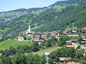
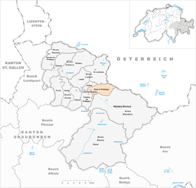
Saas is located on the northern side of the valley of central Prättigau on the edge of the well-known tourist region Klosters / Davos , about ten kilometers northwest of Klosters.
The territory stretches from the Landquart over the slope occupied by forest, meadows and pastures to the peaks of the Rätikon . To the south of the ridge that runs from the upstream Saaser Calanda ( 2556 m above sea level ) over the Rätschenhorn (2703 m) to the Madrisahorn (2826 m, highest point in the municipality) lie the extensive alpine meadows of the Saaser Alp . Between Madrisa and Schlappiner Spitz (2442 m), the prelude to the Silvretta , the municipality borders on Austria for around 4 km . South of the Landquart Saas has only a narrow strip, the Enthalbwald, which between Casolf- and Cunterluzitobel up to almost 1500 m above sea level. M. is enough.
In addition to the street village of Saas, located on a terrace around 100 m above Landquart, the community also includes a number of individual farmsteads and mountain pastures .
| Luzein | St. Antönien | Austria |
| Küblis |

|
Klosters-Serneus |
| Conters in the Prättigau | Klosters-Serneus | Klosters-Serneus |
history
The name of 1393 as Sausch (for other, non-verifiable sources by 1290 Säusch ) first mentioned location is loud Rätischem Namenbuch in Latin salsus 'salted' or salsa 'brine' back. The latter denotes in place names both watery, acidic meadows and salty mineral springs or streams; both interpretations can apply to Saas im Prättigau.
Saas belonged in the three leagues as part of the monastery court ( Ausserschnitz together with Küblis, Conters and St. Antönien on the left of the Schanielabach) to the ten-court league decided in 1436. On September 5, 1622, the Prättigau revolt against Austrian rule ended with a defeat at Aquasana on the Saaser Mülitobel. In 1649 the Habsburg valley community was able to buy itself out.
On June 14, 2015, the voters of the two communities Saas and Klosters-Serneus approved the incorporation of Saas into the municipality of Klosters-Serneus on January 1, 2016.
Economy and Transport
The the national highway network belonging Hauptstrasse 28 (called Prättigauerstrasse) runs since October 21, 2011 on the newly opened bypass instead of the current across the village. As one of the main axes between the Rhine Valley and Klosters / Davos / Engadin , it is a busy connection. Saas can now be reached via two connections in the Saaser-Stutz from Küblis and in Serneus-Pagrüegg from Klosters.
The community has had a train station on the Landquart –Klosters line ( Rhaetian Railway ) since 1889 . After the station has only been operated sporadically since 1999, trains have been stopping every hour since 2004. The Küblis – Saas – Klosters bus line also operates.
The mountain station of the Klosters – Madrisa gondola lift and a large part of the ski area of the same name are located on Saas territory. In the village there are two hotels and three guest houses (as of 2020) as well as around 25 holiday apartments. In addition to skiing, there are opportunities for hiking, snowshoeing and sledding (Madrisa – Saas toboggan run, 8.6 km).
Attractions
The village center consists mostly of stately wooden houses that were rebuilt after the village fire in 1735. The reformed village church dates from the late Gothic period (reticulated vaults and tracery windows in the choir ), and the dome of the tower, which can be seen from afar, also dates from 1735.
In the middle of the village on the cantonal road there has been a memorial since 1915 that commemorates the battle of Aquasana in 1622. The monument was erected in a chapel-like shape and houses an oak and a battle picture of Christian Conradin in the style of Ferdinand Hodler .
Personalities
- Anita Hansemann (1962–2019), author
literature
- Otto Clavuot: Saas in the Prättigau. In: Historical Lexicon of Switzerland .
- Erwin Poeschel : The art monuments of the canton of Graubünden II. The valley communities Herrschaft, Prättigau, Davos, Schanfigg, Churwalden, Albula valley. (= Art Monuments of Switzerland. Volume 9). Edited by the Society for Swiss Art History GSK. Bern 1937. DNB 811066703 .
Web links
Individual evidence
- ↑ a b Lexicon of Swiss municipality names . Edited by the Center de Dialectologie at the University of Neuchâtel under the direction of Andres Kristol. Frauenfeld / Lausanne 2005, p. 777 f.
- ↑ Saas and Klosters move into the future together Radio SRF 1 , Regional Journal Graubünden from June 14, 2015


