St. Antönien-Castels
| St. Antönien Castels | ||
|---|---|---|
| State : |
|
|
| Canton : |
|
|
| Region : | Prättigau / Davos | |
| Political community : | Luzein | |
| Postal code : | 7246 | |
| Coordinates : | 781 205 / 205 175 | |
|
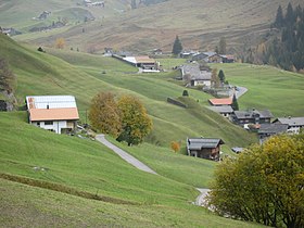
View from the west over the square and Mayerhof. |
||
| map | ||
|
|
||
( Sankt Antönien ) Castels was a neighborhood of high court Castels , since 1851, a municipality in the former district Luzein the district of Upper Landquart in the Swiss canton of Grisons . It comprised the area northwest of the Dalvazzabach with the settlements of Platz , Mayerhof and Aschüel as well as the Alp Partnun . In 1979 it merged with Rüti to form the parish of St. Antönien .
There was an important cattle and goods market in Castels. On the square is the Antonius Church , which was responsible for the entire high valley and gave it its name. The largest avalanche barriers in Switzerland were built on the southern slope of Kühnihorn and Tschatschuggen between 1935 and 1977.
The hamlet of Meierhof was hit by an avalanche on January 20 in the winter of 1951 . This was built below the Kühnihorn and damaged or destroyed 42 buildings, including 9 residential buildings. Ten people were buried, nine of whom were saved; a person was killed. In addition, 50 cattle died.
Attractions
swell
- Otto Clavuot: Sankt Antönien. In: Historical Lexicon of Switzerland .
Individual evidence
- ↑ Béla Zier, In St. Antönien, 50 cattle suffocated in the stables , Die Südostschweiz , January 20, 2001, p. 3 (PDF; 132 kB).
- ↑ Christian Pfister (ed.), The day after. To cope with natural disasters in Switzerland 1500-2000 , Paul Haupt, Bern 2002, ISBN 3-258-06436-9 , p. 158.


