
Fideris
| Fideris | |
|---|---|
 |
|
| State : |
|
| Canton : |
|
| Region : | Prättigau / Davos |
| BFS no. : | 3861 |
| Postal code : | 7235 |
| Coordinates : | 775 511 / 198677 |
| Height : | 897 m above sea level M. |
| Height range : | 732–2472 m above sea level M. |
| Area : | 25.36 km² |
| Residents: | 608 (December 31, 2018) |
| Population density : | 24 inhabitants per km² |
| Website: | www.fideris.ch |
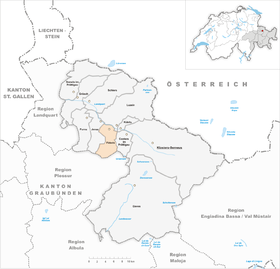
 Fideris |
|
| Location of the municipality | |
  |
|

Fideris ( Walser German [ ˈfɪd̥ɾɪʃ ]; Rhaeto-Romanic ) is a village in the central Prättigau with its own civil parish , Reformed parish and political community . This belongs to the Prättigau / Davos region (until 2001 the Oberlandquart district ) of the Swiss canton of Graubünden .
coat of arms
Blazon : In gold, a catch-ready blue eagle, with red edges.
Transferred from a municipal seal of the 18th century in the colors of the Ten Courts League .
geography
The community is located on the southern side of the central Prättigau . In addition to the main settlement, the cross-shaped street village of Fideris on a terrace above the confluence of the Arieschbach in the Landquart , it includes the districts of Strahlegg on the other side of the Arieschtobel and Fideris-Au in the bottom of the main valley.
The territory largely covers the catchment area of the Arieschbach and extends from the Landquart in the north to the watershed against the Schanfigg . The semicircular head of the valley is taken up by the extensive Alps of the Fideriser Heuberge , behind it the peaks of Mattjisch Horn ( 2,461 m above sea level ) and Chistenstein (2,473 m, highest point in the municipality) rise . After Peist and Langwies several hem and foot paths lead: the Faninpass that Arflinafurgga and Strassberger Fürggli .
Of the total municipal area of 2,532 hectares, 1,538 hectares are used for agricultural purposes (almost 92% of which are alpine farms). Another 698 hectares are covered by forest and wood. A total of 227 hectares are unproductive areas (mostly mountains) and the remaining 69 hectares are settlement areas.
The community borders on Arosa , Conters im Prättigau , Jenaz , Küblis and Luzein .
history
In the eastern part of the village of Madini a 25 cm long lance tip from the Late Bronze Age was found.
The settlement, attested since the 14th century as Fidris / Fideris and 1572 as Foedrain , lies on the former valley road which avoided the flood-prone valley floor and led from Jenaz via Fideris Dorf and Strahlegg to Küblis. As part of the Castels court , the place belonged to the Ten Courts League from 1436 . In 1530 the Reformation was carried out.
Fideris bath
Bad Fideris , located around 2 km south of Fideris am Arieschbach and mentioned in 1464, developed into the most important mineral bath in Graubünden in the 19th century . The healing spring was a sodium- and iron-containing acid. After the spa business was given up in 1939, a ruin destroyed the building in 1967 and buried the spring.
population
The population decreased massively due to emigration between 1850 and 1910 (1850–1910: −23.0%). The first growth spurt followed in the 1910s, followed by stagnation for a decade. Between 1930 and 1960 there was a considerable increase in the population (1930–1960: + 35.2%). Until 1990 there were periods of stagnation, population decline and strong growth. Overall, the population increased moderately (1960–1990: +6.7%) - and then stagnated in the 1990s. Since 2000 the population has increased again slightly.
| Population development | ||||||||
|---|---|---|---|---|---|---|---|---|
| year | 1850 | 1910 | 1930 | 1960 | 1980 | 1990 | 2004 | |
| population | 460 | 354 | 406 | 549 | 492 | 586 | 599 | |
languages
In the early Middle Ages, the population of the community still spoke Romansh ; the Romanesque place name is Fadrein . In the 14th century Walser immigrated , whose presence on Tarnutz has been documented since 1389. At the time of the Reformation, Germanization was already complete. The only official language of the municipality is German. Today the community is almost uniformly German-speaking, as the following table shows:
| Languages in Fideris | ||||||
| languages | 1980 census | 1990 census | 2000 census | |||
| number | proportion of | number | proportion of | number | proportion of | |
| German | 485 | 98.58% | 557 | 95.05% | 565 | 96.42% |
| Romansh | 6th | 1.22% | 6th | 1.02% | 4th | 0.68% |
| Italian | 0 | 0.00% | 2 | 0.34% | 3 | 0.51% |
| Residents | 492 | 100% | 586 | 100% | 586 | 100% |
Religions - denominations

Fideris adopted the new (reformed) doctrine around 1530, which dominated for centuries. Religious conditions have changed in recent decades as a result of leaving the church and immigration. In 2000 there were 84% Evangelical Reformed and 9% Roman Catholic Christians.
Origin - nationality
Of the 599 residents at the end of 2004, 579 (= 96.66%) were Swiss citizens. At the last census, 554 (= 94.54%) were Swiss citizens, including six dual citizens. The largest groups of immigrants come from Germany, Portugal and Italy.
politics
The mayor is Marianne Flury (as of 2011).
Attractions
As the only Prättigau village, Fideris was spared the destruction by the Austrians in 1622, so that a number of stately town houses have been preserved in the village center.
- The Gujan house emerged from a residential tower from the 11th century.
- The Reformed Church , built in 1461 - apart from the tower that was rebuilt in 1740 - is a late Gothic building with a reticulated choir and wall paintings from the construction period.
- Former Valär house
- RhB reception building
- The ruins of the Strahlegg Castle stand by the hamlet of Strahlegg . The stump of the main tower and the remains of the wall of the residential wing are still present from the 13th century building.
literature
- Erwin Poeschel : The art monuments of the canton of Graubünden II. The valley communities Herrschaft, Prättigau, Davos, Schanfigg, Churwalden, Albula valley. (= Art Monuments of Switzerland. Volume 9). Edited by the Society for Swiss Art History GSK. Bern 1937. DNB 811066703 .
Web links
- Official website of the municipality of Fideris
- Otto Clavuot: Fideris. In: Historical Lexicon of Switzerland .
- Dialect Prättigau - Fideriser dialect, spoken by Conradin Gujan (1988), on srf.ch
Individual evidence
- ↑ Permanent and non-permanent resident population by year, canton, district, municipality, population type and gender (permanent resident population). In: bfs. admin.ch . Federal Statistical Office (FSO), August 31, 2019, accessed on December 22, 2019 .
- ↑ a b Fideris GR (Prättigau / Davos) in: Andres Kristol & al., Dictionnaire toponymique des communes suisses - Lexicon of Swiss municipality names - Dizionario toponomastico dei comuni svizzeri (DTS | LSG). Center de dialectologie, Université de Neuchâtel, Verlag Huber, Frauenfeld / Stuttgart / Vienna 2005, ISBN 3-7193-1308-5 and Éditions Payot, Lausanne 2005, ISBN 2-601-03336-3 , p. 354
- ↑ Peter Nichols Richardson: German - Romance Contact. Name-giving in Walser settlements , Amsterdam 1974, ISBN 90-6203-221-4 , p. 29
- ↑ Former Valär House at www.graubuendenkultur.ch
- ↑ Reception building of the RhB at www.graubuendenkultur.ch
Conters in the Prättigau | Davos | Fideris | Furna | Grüsch | Jenaz | Klosters-Serneus | Küblis | Luzein | Schiers | Seewis in the Prättigau
Former parishes: Buchen | Cavadura | Fanas | Hintervalzeina | Monastery | Pany | Plaster | Saas im Prättigau | Schuders | Serneus | St. Antönien | St. Antönien Ascharina | St. Antönien-Castels | St. Antönien Rüti | Valzeina | Vordervalzeina
Canton of Graubünden | Regions of the Canton of Graubünden | Municipalities of the Canton of Graubünden