Fanas
| Fanas | ||
|---|---|---|
| State : |
|
|
| Canton : |
|
|
| Region : | Prättigau / Davos | |
| Political community : | Grüsch | |
| Postal code : | 7215 | |
| former BFS no. : | 3971 | |
| Coordinates : | 769 454 / 206154 | |
| Height : | 904 m above sea level M. | |
| Area : | 21.84 km² | |
| Residents: | 401 (December 31, 2010) | |
| Population density : | 18 inhabitants per km² | |
| Website: | www.fanas.ch | |
|
Fanas |
||
| map | ||
|
|
||

Fanas [ fɐˈnɔːs ] is a village and a Reformed parish in the front Prättigau , Canton of Graubünden . Politically, it has belonged to the political municipality of Grüsch since the beginning of 2011 , together with Valzeina , who was also previously independent . The village had already belonged to the Schiers District Court between 1679 and 1729, which was created through the separation of the Seewis District Court from the Schiers Court, which in turn went back to the rule of Solavers .
Name and coat of arms
The place name has appeared in several variants since the 13th century: 1224 [cop.] De Faenane… de Fenane; 1291 in villis Sewns et Affenans; 1296 to Fenatis; 1375 fenans ; 1447 Vanaus . The origin of the name is unknown; The evidence from 1296 and later forms could be traced back to the Latin fenatum , `` place where we have been '' , with Graubünden field names such as Fanaus and Sotfanas , but the -n- in the word ending , which has been attested several times and in some cases earlier, remains unexplained.
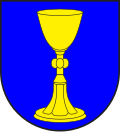
The coat of arms is taken from a community seal from 1817 and has received the colors of the Ten Courts Association . The blazon reads: A golden goblet in blue .
geography
The street village Fanas is located on a terrace on the northern side of the front Prättigau . The territory covers part of the area between Taschinasbach and Schraubach , two right tributaries of the Landquart . The highest point is the Girenspitz ( 2394 m above sea level ) in the north-east, which forms the end of the Salginatobel . Seen from the village, the upstream ridge of the Sassauna (2308 m) dominates.
Of the entire former municipal area of 2183 hectares, 983 are agricultural areas, including 775 hectares of alpine farms. A further 804 hectares are covered by forest and wood, 381 hectares of unproductive area (mostly mountains) and 15 hectares of settlement area.
population
| Population development | |||||||
|---|---|---|---|---|---|---|---|
| year | 1850 | 1920 | 1950 | 1970 | 2000 | 2005 | 2010 |
| population | 373 | 250 | 303 | 228 | 346 | 385 | 401 |
Due to strong emigration, the population decreased considerably between 1850 and 1920 (1850-1920: −33%). Two decades of growth were followed by ten years of stagnation (1920–1950: +21%). Between 1950 and 1970 there was a second major wave of emigration (1950–1970: −25%). The population grew rapidly up to the year 2000 (1970–2000: +67%). Since then it has stagnated at a high level of around 380 people.
languages
The population originally spoke Romansh . But the language change to German took place around the middle of the 16th century. Today the community is practically monolingual in German.
| Languages in Fanas | ||||||
| languages | 1980 census | 1990 census | 2000 census | |||
| number | proportion of | number | proportion of | number | proportion of | |
| German | 271 | 97.48% | 333 | 96.24% | 370 | 98.14% |
| Romansh | 2 | 0.72% | 0 | 0.00% | 1 | 0.27% |
| Residents | 278 | 100% | 346 | 100% | 377 | 100% |
Religions - denominations
The Reformation was introduced in the former community between 1560 and 1570 . In 2000, 78% were Protestant and 9% Roman Catholic Christians. In addition, there were 9% non-denominational. 2.92% of the population refused to provide information about their creed.
Origin - nationality
Of the 383 residents at the end of 2004, 371 (= 97%) were Swiss citizens. At the last census, 371 people (= 98%) were Swiss citizens, including two dual citizens. The few immigrants come from Germany, Finland, Macedonia and Great Britain.
Economy and Transport
Fanas is still rural, but at the end of the 20th century it also developed into a popular residential community. There is a post bus connection to Schiers .
The Fanas – Eggli cable car leads from the village to the mountain station (1700 m above sea level) on the slope of the Sassauna. In summer it is mainly used by hikers and paragliders , in winter by ski tourers.
Attractions
- The reformed village church is a listed building .
- Maiensäss Rageth (1999); Architects: Valentin Bearth , Andrea Deplazes , Daniel Ladner
Web links
literature
- Otto Clavuot: Fanas. In: Historical Lexicon of Switzerland .
- Erwin Poeschel : The art monuments of the canton of Graubünden II. The valley communities Herrschaft, Prättigau, Davos, Schanfigg, Churwalden, Albula valley. (= Art Monuments of Switzerland. Volume 9). Edited by the Society for Swiss Art History GSK. Bern 1937.
Individual evidence
- ↑ a b Dictionnaire toponymique des communes suisses - Lexicon of Swiss municipality names - Dizionario toponomastico dei comuni svizzeri (DTS | LSG). Edited by the Center de dialectologie at the University of Neuchâtel under the direction of Andres Kristol. Verlag Huber, Frauenfeld / Stuttgart / Vienna 2005, ISBN 3-7193-1308-5 and Éditions Payot, Lausanne 2005, ISBN 2-601-03336-3 , p. 346.
- ↑ Fanas: Fanas – Eggli cable car
- ↑ Maiensäss Rageth


