
Scaläratobel

The Scaläratobel is located northeast of the city of Chur and in the south of the village of Trimmis in the canton of Graubünden in Switzerland . The border between the two communities runs through the ravine.
Surname
The name Scalära can be derived from the Romansh scala / stgala (stairs) and aria (air, sky); means something like "ladder to heaven". The name probably refers to the two mountain ranges rising like a staircase, the Rote Platte and the Hochgang , which border the ravine on both sides.
description
The wooded, deeply cut and inaccessible ravine lies on the northwest slope of the Hochwang chain . It begins at an altitude of 1900 meters on the ridge of the Fürhörnli and extends for a length of around 1.8 kilometers to the south, where it merges into the Scalärarüfi at 900 meters. There the brook joins the Maschänserrüfe, which flows in from the east. The water of the two streams flows to the northwest through uninhabited area and flows into the Rhine after 2.3 kilometers .
Protected area
Around 1900 the Chur City Association proposed the creation of the Scaläratobels zoological reserve. Well-known personalities from politics, art and science were able to convince the skeptical city and canton authorities of the sense of their concern and so it was decided in 1912 to create a "game asylum", which also included a hunting ban for predatory game. Paul Sarasin , one of the co-founders of the Swiss National Park , suggested the creation of a reserve with strict protection of all plants and animals, but could not prevail.
Rüfi
The Grisons slate, which is highly susceptible to weathering and into which the two streams have dug itself, delivers large amounts of debris from a catchment area of around six square kilometers when it rains heavily , which flows as debris flows to the valley floor and the Rhine. In 1964, when the two streams were merged , a first sediment collector was built to protect the tracks of the RhB , SBB and the A13 motorway and cantonal road. Between 2003 and 2005 a new collecting basin was built that can hold 150,000 m 3 of rubble. 18,000 tons of stone blocks were placed to protect against erosion, and 1,700 m 3 of concrete were used for the outflow structure and to secure the bottom . The side walls of the first fortification can still be seen further upstream.
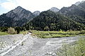
Left the Maschänserrüfe, right the Scalärarüfe. In the background the rising mountains
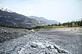
Debris collector at the exit of the ravine
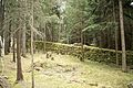
Old protective wall


legend

According to a legend , the Scaläratobel is the special hell of the residents of Chur: after their burial in the old Waldhaus cemetery, all those who “did not do right” are taken from the grave by two Capuchins and led through the forest into the Tobel, where they are for their sins have to pay. In 1903, Constanz Ciprian Fischer from Chur described in a poem in the Bündner calendar : “The ghost haunt in the Scalära Tobel”, what the wrongdoers had to endure. The Tyrolean author Christian Kössler took up the legend in his 2015 work “She will get you” with the text “Let the dead” as well.
Others
- To the east, above the sediment collector, lie the ruins of Ober-Ruchenberg Castle on a hill .
- The Chur scout department and a country chapel are named after the Scaläratobel.
Web links
Individual evidence
- ↑ Jürg Paul Müller in the magazine kultchur , No. 33, March 2014, p. 32f
- ↑ Graubünden Civil Engineering Office (PDF; 623 kB)
- ^ Charles Knapp, Maurice Borel, Victor Attinger, Heinrich Brunner, Société neuchâteloise de geographie (editor): Geographical Lexicon of Switzerland . Volume 4: Plessur - Switzerland . Verlag Gebrüder Attinger, Neuenburg 1906, p. 505, keyword Scalæratobel ( scan of the lexicon page ).
- ↑ Path Chur
- ↑ Ländlerkapelle