Mastrils
| Mastrils | ||
|---|---|---|
| State : |
|
|
| Canton : |
|
|
| Region : | Landquart | |
| Political community : | Landquart | |
| Postal code : | 7303 | |
| former BFS no. : | 3943 | |
| Coordinates : | 760 115 / 203 848 | |
| Height : | 550 m above sea level M. | |
| Area : | 7.98 km² | |
| Residents: | 556 (December 31, 2011) | |
| Population density : | 70 inhabitants per km² | |
| Website: | www.landquart.ch | |
| map | ||
|
|
||
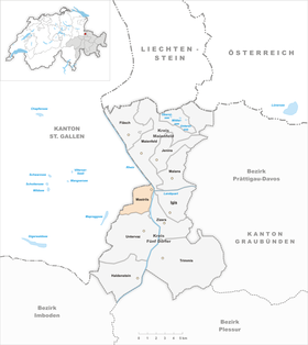
Mastrils was until December 31, 2011 a political municipality in the former Five Villages district , in what was then the Landquart district of the Swiss canton of Graubünden .
On May 15, 2011, the residents of Igis and Mastrils agreed to merge their parishes. The new municipality of Landquart was formed on January 1, 2012.
geography
Mastrils is located 13 kilometers (as the crow flies) north of Chur on the left bank of the Rhine , opposite the Landquart estuary . The territory extends from the hard running at the foot of the slope Rhine up to the ridge of Calandamassiv that far from the Zweienchopfs the with 1825 m above sea level. M. marks the highest point of the municipality and gradually drops to the north over Chimmispitz (1813 m) and Pizalun (1478 m). The houses are scattered on the slope, there is no actual village center. The Isla district (554 m) is located directly on the banks of the Rhine, the remaining settlements are mostly close to the road that leads from the Tardis Bridge in several bends up to Tretsch (690 m). Above is a zone of Maiensässen .
In 1997, 23.9% of the community area was used for agriculture, the forest took up 68.8%, the settlements 2.5%. 4.9% were considered unproductive.
Mastrils borders on Maienfeld , Zizers , Untervaz and the St. Gallic communities Pfäfers and Bad Ragaz .
coat of arms
The coat of arms of the former municipality of Mastrils was in effect until December 31, 2011 and looked like this:
Blazon : Black key set in silver on stilts
The basis of the coat of arms is the community seal from 1600. The motif refers to the patron of the former parish church of Mastrils in Zizers, St. Peter . The colors correspond to those of the church association .
With the merger to form the new Landquart municipality , a new coat of arms was created.
history
Mastrils only formed an independent municipality since 1854. Before that, the settlement on Ponstrilserberg , as the older form of the name mentioned in 1318 was, belonged to Zizers . Like the mother community, the place has been denominationally mixed since the 17th century. The two churches were consecrated in 1614 and 1688 respectively.
economy
Mastrils developed into a commuter residential community in the 20th century. At the site itself (as of 2000–01) 40 people were employed in agriculture and forestry, 16 in the commercial sector and 23 in the service sector. There is a school, a Protestant and Catholic church, three restaurants , a nursing home , a travel agency , and one Ski lift , an inn and other small business facilities.
traffic
The former municipality is connected to the public transport network with a post bus line to Landquart train station .
Attractions
- The Catholic parish church and the Reformed village church are listed as historical monuments .
- School and community center, 1995, architects: Andreas Hagmann , Dieter Jüngling
literature
- Adolf Collenberg: Mastrils. In: Historical Lexicon of Switzerland .
- Erwin Poeschel : The art monuments of the canton of Graubünden. Volume VII: The city of Chur and the district of five villages (= art monuments of Switzerland. Volume 20). Edited by the Society for Swiss Art History GSK. Bern 1948, DNB 760079668 .
Web links
- Official website of the municipality of Landquart, to which the Mastrils part of the village belongs
Individual evidence
- ↑ Igis and Mastrils Agree to Merger. In: Südostschweiz online. May 15, 2011, accessed May 15, 2011.
- ↑ School and Community Center at www.graubuendenkultur.ch .


