
Calanda (mountain range)
| Calanda | ||
|---|---|---|
 Felsberger and Haldensteiner Calanda |
||
| height | 2804 m above sea level M. | |
| location | Canton of Graubünden / Canton of St. Gallen , Switzerland | |
| Mountains | Glarus Alps | |
| Dominance | 6.5 km → Panärahorns | |
| Notch height | 1446 m ↓ Kunkelspass | |
| Coordinates | 754 558 / 196 319 | |
|
||
 Map: Calanda |
||
 Small summit cross and summit book box on the Haldensteiner Calanda |
||


The Calanda is a mountain range in Switzerland . It is located in the northern part of the canton of Graubünden or south of St. Gallen and northwest of Chur . Its highest peak is at 2804 m above sea level. M. the Haldensteiner Calanda .
The massif belongs to the northern limestone Alps and forms the easternmost end of the Glarus Alps . The Calanda chain is part of the Tamina Mountains with the Graue Hörner (Pizol) group, the Sazmartinhorn chain, the Sardona massif and the Ringelgebirge . The Calanda mountain range is a mountain range bounded in the southeast by the Chur Rhine Valley , in the northwest by the Tamina valley and only separated from the Ringel Mountains by the 1358 m high Kunkelspass .
Geography and nature
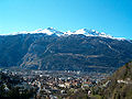
The ridge of the Calanda is composed of a series of peaks and extends from the southwest to the northeast. The south-western corner is formed by the Taminser Calanda ( 2389 m above sea level ), followed by the Felsberger Calanda ( 2695 m above sea level ), the Haldensteiner Calanda, at 2804 m above sea level. M. the highest elevation of the group, and finally the Berger Calanda ( 2270 m above sea level ). From here the ridge descends steadily over Zweienkopf, Chimmispitz and Pizalun and finally reaches the valley floor south of Bad Ragaz. The canton border between Graubünden and Sankt Gallen runs over the central ridge of the Calanda. To the north, the Calanda drops very steeply with striking rock faces towards the Tamina valley , while towards the Rhine valley the terrain is flatter, at least in the upper part. Extensive Alps extend here with mountain pastures named after the respective communities at the south and east foot of the massif, such as the Taminser Älpli , the Felsberger Älpli , the Haldensteiner Alp and the Vazer Alp .
The vegetation on the south and south-east slopes exposed to the sun has adapted to the drought and has partly Mediterranean features.
The first wolf pack in Switzerland since the re-immigration of wolves from Italy has been living on Calanda since 2012 .
geology
Geologically, the Calanda belongs to the Helvetic nappes, which in this area mainly consist of Mesozoic sediments, namely Malm and chalk limestone. In the 19th century, small amounts of gold were mined on the southern slope of Felsberger Calanda.
The name Calanda is derived from the Latin calare , which means to condescend . So Calanda is “the condescending one” , which indicates the numerous riffs and landslides down to the valley floor of the Rhine Valley in earlier times. Rock falls have also occurred in recent times ; the one from 1843 threatened the village of Felsberg and led to the Neudorf settlement being built further away from the foot of the slope. The last major rockfalls took place in 2001 and 2002.
At the end of the 20th century, the Calanda massif got into heated discussions; It was planned to build oil deposits in underground caverns for times of crisis. People felt at risk far into southern Germany, as the Alpine Rhine flowing past the foot of the mountain flows into Lake Constance , which acts as a drinking water reservoir by means of a pipeline to secure Stuttgart's water supply . There was talk of porous stone and the risk of earthquakes in the region. The planners, on the other hand, consider the project to be largely safe, not least because of the immense strength of the rock faces.
The Golden Sun mine was at the foot of the Felsberger Calanda .
Forest fire of 1943
On August 20, 1943, on the wooded slopes of the Calanda, shooting exercises at a recruiting school for heavy infantry weapons of the Swiss Army led to what is believed to be the largest forest fire in Swiss history. Around 477 hectares of forest fell victim to the fire. The extinguishing work lasted several days.
Development and routes to the peaks
On a terrace at 2074 m above sea level. M. is located high above the Chur Calandahütte of the Swiss Alpine Club SAC. It is the starting point for the mountain hike on the Haldensteiner Calanda. The Calandahütte is easily accessible and an attractive destination for mountain bikers .
Taminser Calanda
From Kunkelspass to the Taminser Älpli

- Starting point: Kunkelspass ( 1357 m )
- Via: Taminser Älpli
- Difficulty: B
- Time required: 2½ hours
From Caschleira, through the northwest flank
- Starting point: Caschleira ( 1056 m )
- Difficulty: BG
- Time required: 4 hours
- Comment: Not in use
From Felsberger Calanda, over the northeast ridge

- Starting point: Felsberger Calanda ( 2697 m )
- Difficulty: L
- Time required: 1 hour
From Felsberg, over the Felsberger Älpli
Felsberger Calanda
Via Tüfels Chilchli and the northeast ridge
- Starting point: Calandahütte ( 2073 m ) or Vättis ( 940 m )
- Difficulty: L
- Time required: 3 hours from the Calandahütte or 4¾ hours from Vättis
Through the eastern flank
- Starting point: Calandahütte ( 2073 m )
- Difficulty: L
- Time required: 2¼ hours
About the south side
- Starting point: Calandahütte ( 2073 m )
- Difficulty: L
- Time required: 2½ hours
From Felsberg, over the Felsberger Älpli

From Taminser Calanda, over the south ridge
- Starting point: Taminser Calanda ( 2390 m )
- Difficulty: L
- Time required: 1½ hours
Haldensteiner Calanda
From the Calandahütte, through the eastern flank
- Starting point: Calandahütte ( 2073 m )
- Difficulty: B
- Time required: 2 hours
- Comment: Also winter route
From Vättis, through the southwest face
From Vättis, through the northwest face
About Rossfallenspitz
- Starting point: Mastrilser Alp ( 1755 m ) or Berger Calanda ( 2270 m )
- Difficulty: ZS-
- Time required: 3¾ hours from the Mastrilser Alp or 2½ hours from the Berger Calanda
Berger Calanda
From the south side
- Starting point: Mastrilser Alp ( 1755 m ) or Valer Alp ( 1751 m )
- Difficulty: B
- Time required: 1½ hours
Over the Stelli and the north ridge
- Starting point: Vättis ( 940 m ) or Salez ( 1788 m )
- Difficulty: WS
- Time required: 4¼ from Vättis or 3¾ hours from Salez
panorama

photos
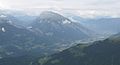
Calanda massif from SW: left Kunkelspass and Tamina valley, right Chur

The Calanda massif seen from the Parpaner Rothorn

The Calanda Hut

Summit of the Haldensteiner Calanda
Calanda of the Schanfiggerstrasse seen from
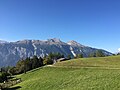
The Calanda group, view from Juchs


literature
- Bernard Condrau, Manfred Hunziker: Club guide, Bündner Alpen , Volume 1 (Tamina and Plessur Mountains) . 4th edition. Verlag des SAC, 1988, ISBN 3-85902-048-X , pp. 224-236.
- Manfred Hunziker : Ringelspitz / Arosa / Rätikon . From the Pass dil Segnas to the Schlappiner Joch. Verlag des SAC, Bern 2010, ISBN 978-3-85902-313-0 , p. 245 ff. ( Alpine Tours - Bündner Alpen ).
- English expect the collapse of the Calanda near Felsberg . In: Fliegende Blätter , Volume 1, 1845, Issue 13, p. 103; satirical contribution ( Wikisource )
Web links
- Calanda tour reports and photos
- The Golden Sun at Calanda - A gold mine at Calanda
Individual evidence
- ↑ The pack. Tages-Anzeiger , February 15, 2015, accessed February 7, 2016 .
- ↑ Dealing with wolves and cormorants: Federal Council puts changed ordinances into force. FOEN , July 1, 2015, accessed on April 29, 2016 .
- ↑ Daniel Steffen: Flight through hell In: Neue Zürcher Zeitung of August 18, 2018
- ↑ 70 years ago a devastating great fire raged on the Calanda
- ^ The forest fire at Felsberger Calanda