
Tamina Mountains
| Tamina Mountains | ||
|---|---|---|
 View of the Grisons, southern side of the Tamina mountains from Brün ; it extends from the western end at the Segnespass (incision over the two fir trees) to the Calanda on the right in the picture. |
||
| Highest peak | Ringelspitz ( 3247 m above sea level ) | |
| location | Switzerland , cantons of St. Gallen , Graubünden and Glarus . | |
| part of | Western alps | |
| Classification according to |
SOIUSA : 13.II.B / b Partizione : 13b |
|
|
||
| Coordinates | 749 303 / 199 027 | |
| particularities | Sardona tectonic arena | |


The Tamina Mountains , in certain Alpine divisions sometimes called Tamina Alps called, is a mountain range in the northeastern part of the Western Alps in Switzerland . The highest peak of the Tamina Mountains is the Ringelspitz ( 3247 m above sea level ).
location
The delimitation and naming of the subgroups of the Tamina Mountains described here is taken from the Alpine Club leaders in use. The division of the Alps according to SOIUSA was not able to prevail in the affected areas. The massifs that surround the Tamina catchment area are located in the northeastern part of the Glarus Alps . Within the Tamina watershed, the land belongs to the canton of St. Gallen, the rest mostly in the canton of Graubünden and only a small part in the Glarnerland . The highest peak of the Tamina Mountains is the Ringelspitz ( 3247 m above sea level ). The mountain group forms the end of the high alpine range from the Bernese Alps via the Urner Alps to the Glarus Alps, the mountains north of the Rhone and the Vorderrhein . According to current Alpine Club guides, the Tamina Mountains are treated separately from the Glarus Alps by the Pass dil Segnas and the Foopass . Several source streams unite on the Sardonaalp in the Calfeisental , about twelve kilometers west of Vättis , to the Tamina. This flows eastward through the narrow Calfeisental, which is flanked by high steep walls. An alpine settlement with a chapel and an inn is located in St. Martin , at the end of the Gigerwald reservoir , which can be reached on a public road from spring to autumn. In Vättis, the Tamina reaches the wide valley floor of the Kunkelspass depression, over which an arm of the Rhine glacier flowed from the south during the Ice Age. Here the mountain stream changes its direction to the north, is soon stored in another small reservoir and then squeezes through the Tamina gorge , in which the thermal springs of Bad Ragaz are captured. The Tamina flows into the Rhine near Bad Ragaz .
Boundary and subgroups
- In the east and south, the Rhine forms the border from Sargans upstream to the confluence of the Hinterrhein near Reichenau and further along the Vorderrhein to the confluence of the Flem in the Rhine Gorge (Ruinaulta) .
- In the southwest along the Flem through the Val Pintrun and uphill through the village of Flims in the Unter Segnasboden (Segnas Sut) and on to the Pass dil Segnas ( 2625 m above sea level ).
- In the west from the Pass dil Segnas to the Foopass ( 2223 m above sea level ).
- In the north from the Foopass to the Foobach and along the brook to the confluence with the brook Seez . Along the Seez through the Weisstannental out to Mels and Sarganser Au to the Rhine .
Gray horns (Pizol)
To the west of the Tamina, above the Rhine plain from Sargans , lies the Pizol area, a sports area popular in summer and winter with numerous hiking trails and transport facilities. Further south, the slopes become steeper and the mountains rougher, which is reflected in the visitor frequency. The Pizol ( 2844 m above sea level ) is the southernmost peak here that is often climbed.
Calanda chain
Separated by the hollow of the Kunkelspass, the Calanda chain rises between the Tamina valley and the Chur Rhine valley with the main summit Haldensteiner Calanda ( 2805 m above sea level ), the local mountain of the Graubünden capital Chur . An SAC hut, the Calandahütte , is ideal as a stage stop here.
Ringelgebirge
The peaks of the Ringelspitz group flank the Calfeisental on its south side with their steep walls. They are mighty rocky mountains, the ascent of which not only requires good physical condition, but also some alpine skills, especially in climbing on easy, but not very reliable rock. The Ringelspitz is at 3247.4 m above sea level. M. the highest peak of the Tamina mountains and at the same time the highest peak in the canton of St. Gallen . It is the coveted summit destination of visitors to the Ringelspitzhütte on the southeast side of the group.
Sardona massif
The western end of the Calfeisen is formed by the Sardonagruppe, a mountain range that - as part of the Glarus Thrust - belongs to the Tectonic Arena Sardona World Natural Heritage Site and is geologically very interesting, but has some demands in terms of alpinism. The Sardona group faces north-south and is much more accessible from the east than from the west. The western flank of Elm in the canton of Glarus is heavily eroded. The older Verrucano , which lies on the younger layers of slate, has offered more resistance to erosion, which has led to slate and debris slopes that are difficult to negotiate. The Sardonahütte at the eastern foot of the group is a conveniently located base, above it is (still) a small glacier area, which requires adequate equipment to be accessed. The Sardona group runs out towards the southwest in the ski area of Flims. Numerous hiking trails have also been laid out from this tourist resort. The highest mountain here is the Piz Segnas ( 3099 m above sea level ).
Chain Sazmartinshorn - Älplichopf
The chain of the Sazmartinshorn ( 2827 m above sea level ) flanks the Calfeisen valley on the north side. The alpine areas below the peaks, at around 2000 meters above sea level, offer space for hiking. But the mountains especially enjoy the attention of the locals. The tours are not only undertaken from Calfeisen, but also from the Weisstannental .
Pictures of the groups

Sardona group from the west (Glarus side) to (from left) Piz Sardona, Piz Segnes (highest point), Atlas and Tschingelhörner, the latter no longer belong to the Sardona group.
Sardona group from the southeast (Grisons side) with (from left) Atlas, Piz Segnes (highest point), Piz Sardona covered by Piz Dolf.

Sardona group from the southeast (Grisons side) with Flimserstein and behind (from left) Atlas, Piz Segnes (highest point), Piz Dolf. The Tschingelhörner on the left do not belong to the Tamina Mountains and the Piz Sax on the right to the Ringelgruppe.

Northern flank of the Calfeisental from Plattenspitz / Hangsackgrat left to Zanaihörner right next to the Sazmartinhorn

Ringelgebirge left and Calanda massif right seen from the south, in between the Kunkelspass .
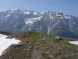
Ringelgebirge seen from the direction of the Heidelpass over the Calfeisental; Ringelspitz left as the highest point on the horizon and Piz da Sterls a little to the left of the signpost.

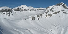
Calfeisental with Gigerwald reservoir and the surrounding mountains; from the left Haldensteiner Calanda and Felsberger Calanda, then the chain with organs and panarah horns (tips without individual names) up to the Ringelspitz, which is the thin needle at the highest point on the horizon. To the right of the Ringelspitz the Glaserhorn.
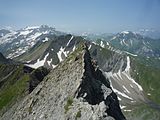
The line from the Alplichopf in front of the Piz Sardona (which is the highest point on the horizon) to the Hangsackgrat (approx. Photo location)

Ringelgebirge : View from Dorfbärg above the village of Valendas over the Rhine Gorge to the Ringelgebirge.


Literature / source
- Bernard Condrau: Tamina and Plessur Mountains, Club Guide Bündner Alpen 1. , SAC publishing house, 1988, ISBN 3-85902-048-X .
- Manfred Hunziker: Ringelspitz / Arosa / Rätikon, Alpine Tours / Bündner Alps. , Verlag des SAC, 2010, ISBN 978-3-85902-313-0 .