Heidelpass
| Heidelpass | |||
|---|---|---|---|
|
Pass height |
|||
| Compass direction | North | Southeast | |
| Pass height | 2387 m above sea level M. | ||
| Canton | St. Gallen | St. Gallen | |
| Watershed | Seez , Walensee | Tamina → Rhine | |
| Valley locations | Weisstannen , Weisstannental | Vättis , Tamina Valley | |
| Map (Canton of St. Gallen) | |||
|
|
|||
| Coordinates | 744 117 / 201135 | ||
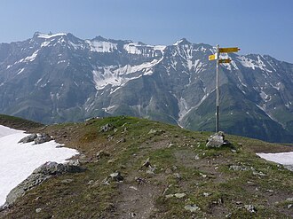
The Heidelpass ( 2387 m ) is a mule track in the Swiss Alps . It connects the community of Weisstannen in the Weisstannental with the Calfeisental and further to Vättis in the Tamina valley , both in the canton of St. Gallen . The Heidelpass is on the fourth stage of the Sardona World Heritage hiking trail , the transition is marked white-red-white. From the Heidelpass a hiking trail leads along the northern slopes of the Calfeisental, below the Plattenspitz ( 2579 m ) through to the Heubützlipass to the west .
Web links
Commons : Heidelpass - collection of images, videos and audio files


