
Col de Soladier
| Col de Soladier | |||
|---|---|---|---|
_(cropped)_Col_de_Soladier.jpg) View from Col de Lys to the Soladier, on the left Vanil des Artses and Le Pila , on the right Le Molard , in front of the valley of the Veveyse de Fégire, in the background the massif of the Cornettes de Bise |
|||
| Compass direction | north | south | |
| Pass height | 1576 m above sea level M. | ||
| Canton | Vaud | ||
| Watershed | Veveyse de Fégire | Baye de Montreux | |
| Valley locations | Châtel-Saint-Denis | Les Avants | |
| expansion | Footpath | Track | |
| map | |||
|
|||
| Coordinates | 563800 / 147371 | ||

The Col de Soladier ( 1576 m ) is a pass in the foothills of the Swiss canton of Vaud .
location
From the pass in a north-westerly direction there is a ridge to the Molard ( 1751 m above sea level ), to the south-east the terrain rises to the ridge where Le Pila ( 1891 m above sea level ) and Cape au Moine ( 1941 m above sea level ) meet . M. ) are located.
The pass connects the Alp de Caudon in the upper valley later in the Veveyse opens de Veveyse Fégire with the pastures of Soladier and Les Béviaux in the valley of Baye de Montreux above Les Avants .
Surname
The name is derived from Sor la Dy (above the Dy) , the southern source of the Baye de Montreux.
geology
The substrate consists of fossil-leading slate from the series of the Lower Jurassic (Lias).
tourism
The pass serves on the one hand as a transition from Les Avants to Châtel-Saint-Denis , on the other hand, hiking trails lead from there to Le Folly and Le Molard to the northwest and to the southeast to the Col de Jaman ( 1512 m above sea level ) and Col de Pierra-Perchia ( 1860 m above sea level ). From the latter, the Cape au Moine or the Allières and Les Cases stops on the Montreux – Lenk railway in the Simmental in the canton of Friborg can be reached on a challenging alpine hiking trail (T5) .
In winter, the pass can be reached on touring skis .
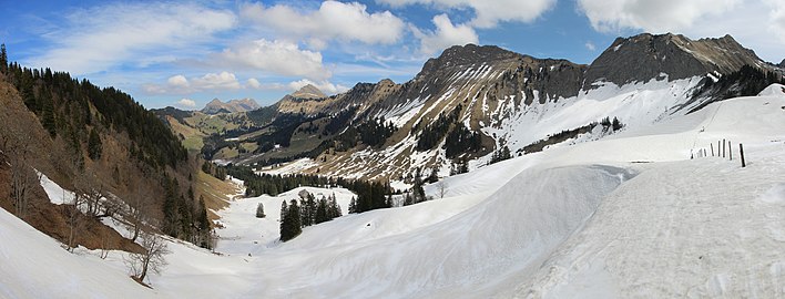
View from Col de Soladier to the north into the valley of the Veveyse de Fégire, on the left the slope of the Molard , the rocky mountains are from left to right Moléson , Dent de Lys , Vanil des Artses and Le Pila

Web links
- Col de Soladier on hikr.org
Individual evidence
- ↑ a b c Col de Soladier on the national map of Switzerland .
- ^ A b c Charles Knapp, Maurice Borel, Victor Attinger, Heinrich Brunner, Société neuchâteloise de geographie (editor): Geographical Lexicon of Switzerland . Volume 5: Switzerland - Tavetsch . Verlag Gebrüder Attinger, Neuenburg 1908, p. 595, keyword Soladier (Col du) ( scan of the lexicon page ).
Albrun | Antrona | Augstbord | Balme | Barna | Bocchetta di Val Maggia | Boeuf | Bunder bark | Carmenna | Carnusa | Casanna | Chaschauna | Chésery | Cheville | Chräzeren | Chrüzli | Corno | Cristallina | Cou | Diesrut | Durand | Duranna | Encel | Euschels | Ferret Grand | Ferret Petit | Foo | Fórcola | Fuorcla Surlej | Fuorcla da Patnaul | Furcletta | Futschöl | Goat path | Gemmi | Giümela | Gredigs Fürggli | Greina | Semolina | Grünenberg | Güner Lückli | Gurin Furggu | Heidel | Heubützli | Hörnligrat | Illsee | Yoke | Jorat | Kinzig | Boxes | Kleine Scheidegg | Lona | Soldering | Lys | Maienfelder Furgga | Meidpass | Menouve | Monte Moro | Muretto | Naret | Niemet | Panixer | Pontimia | Rawil | Redorta | Riseten | Rotstein | Saas | Safierberg | Saflish | San Giacomo | San Jorio | Saddle | Scaletta | Schlappiner yoke | Schnidejoch | Schonegg | Schwialp | Segnes | Septimer | Sertig | Soladier | Soreda | Stallerberg | Strela | Surene | Susanfe | Tamier | Theodule | Tomül | Torrent | Trescolmen | Trütlisberg | Urdenfürggli | Valserberg | Zeblasjoch | Between mountains