Gredigs Fürggli
| Gredigs Fürggli | |||
|---|---|---|---|
|
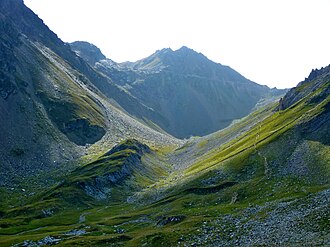
Gredigs Fürggli (right) with the hiking trail from Arosa to Parpaner Rothorn |
|||
| Compass direction | east | west | |
| Pass height | 2615 m above sea level M. | ||
| Canton | Graubünden , Switzerland | ||
| Watershed | Plessure | Rabiosa | |
| Valley locations | Arosa | Lenzerheide / Parpan | |
| expansion | Mountain hiking trail and ski slope | ||
| Mountains | Plessur Alps | ||
| map | |||
|
|
|||
| Coordinates | 765 076 / 180513 | ||
The Gredigs Fürggli is an alpine pass in the Swiss canton of Graubünden . With a peak height of 2615 m above sea level. M. connects Arosa with Vaz / Obervaz and Parpan .
Description and name
A frequently used, marked hiking trail leads across Gredigs Fürggli, located between the northern foothills of the Parpaner Rothorn and the Parpaner Weisshorn . This also serves as an ascent or descent route to the above-mentioned peaks as well as to the Aroser Rothorn and the Älplihorn and, in conjunction with Urdenfürggli and Hörnligrat, offers a popular round trip Arosa Schwellisee - Älplisee - Hörnlihütte -Arosa. The former Arosa mountain farmer family Gredig, who owned alpine pastures near Totseeli above the Plessur spring , gave the pass its name.
history
In contrast to the route via the Urdenfürggli, the German-speaking Walsers who have settled in Arosa since the beginning of the 14th century used the Gredigs Fürggli significantly less often as a transition to the Rhaeto-Romanic Obervaz, to which they were part of the church until their own church was built in Langwies in 1384/85 . This route was further, more arduous and also led higher up.
The east side of the transition was developed quite early through use as alpine area for sheep and through the mining activities of the Plurs family Vertemati 1450–1550 in Totälpli and the Goldgruaba, where pyrite had been found. On the west side, however, for a long time only a sparse track in the fall line led from the top of the pass through the steep scree slope and then along the rock in a south-westerly direction to Valbella .
Tourist use
In the course of the construction of the Rothornbahn in 1963, the operating company received permission from the municipality of Arosa to open up the Totälpli area with ski slopes and to create a connecting gallery through the east face of the summit 2762 to Gredigs Fürggli. At the same time, this was connected by a wide path along the west side of the Parpaner Weisshorn with the existing hiking path from Alp Scharmoin to Urdenfürggli.
With this new high-altitude trail, the Parpaner Rothorn has been significantly upgraded for both mountain hikers and skiers. At the same time, the Gredigs Fürggli was now also much easier to reach from the west, and it has enjoyed correspondingly high frequencies since then. Today the transition is mainly used by mountain hikers, mountain bikers and ski (touring) drivers. In winter, an easy variant run leads from the pass over the Älpli to Arosa. All accesses have a level of difficulty T2 .
Sports event
The Swiss Irontrail , which was held for the first time in July 2012, was to lead from the Parpaner Rothorn via the Gredigs Fürggli to Arosa and from there via Weisshorn and Carmenna towards Ausserschanfigg . Since a route change in 2013, the Gredigs Fürggli is no longer part of this sporting event.
Varia
The legendary Tüfelsch Ruobstei is located on the path between the Älplisee and the top of the pass .
The Gredigs Fürggli-Älplisee- Schwellisee- Arosa area is not affected by the Arosa Lenzerheide ski area connection, which was implemented in 2013/14 .
swell
- Hans Danuser : Arosa place and field names with inclusion of the Welschtobel and some areas near the border in neighboring communities, self-published Danuser, Arosa 2011, ISBN 3-905342-49-9 , pp. 17, 65, 98, 158 ff.
- Manfred Hunziker: Ringelspitz / Arosa / Rätikon , Alpine Tours / Bündner Alpen , Verlag des SAC 2010, ISBN 978-3-85902-313-0 , p. 307 f.
- Hans Danuser, Walser Association Graubünden (ed.): Old ways in Schanfigg. Verlag Walser-Vereinigung Graubünden, Splügen 1997, p. 161.
- Heinrich Tgetgel, Schweizer Wanderbuch 30 , Schanfigg – Arosa, 3rd edition, Bern 1971, p. 88 ff.
- Fritz Maron: From mountain farming village to world health resort Arosa , Verlag F. Schuler, Chur 1934, p. 138.


