
Scaletta Pass
| Scaletta Pass | |||
|---|---|---|---|
 The highest point |
|||
| Compass direction | North | south | |
| Pass height | 2606 m above sea level M. | ||
| Canton | Graubünden , Switzerland | ||
| Valley locations | Davos | S-chanf | |
| expansion | trail | ||
| Mountains | Albula Alps | ||
| map | |||
|
|||
| Coordinates | 789 803 / 174285 | ||

The Scalettapass ( Rhaeto-Romanic ) is an alpine pass in the Swiss canton of Graubünden . With a peak height of 2606 m above sea level. M. it connects the Engadin with Davos and the Prättigau via the Val Susauna and the Dischma valley . At the summit, the European runs watershed between the basins of the Rhine and Inn . The highest mountain next to the pass is the Chüealphorn .
In the summer months, the Scalettapass is on the routes of many hikers and mountain bikers. Every year the Swiss Alpine Marathon leads over the top of the pass.
history
The Scalettapass ( s-chaletta : Rhaeto-Romanic for "small stairs") is located on a medieval inner-alpine route from Chur via Davos to S-chanf into the Engadine and over the Chaschauna pass to Livigno and Valtellina. This " Via Valtellina " can be a multi-day hike be understood. The former mule villages Dürrboden on the Davos side and Susauna on the Engadine side as well as the Chapella hospice at the exit of the Val Susauna bear witness to the former traffic activity . With the construction of the Flüelapassstrasse from 1866 to 1868, the Scalettapass lost its economic importance.
Plans for a continuous rail link from Chur via Landquart and Davos to St. Moritz and further over the Malojapass to Chiavenna , Italy, presented in 1890 by the Davos hotelier Willem Jan Holsboer , were not implemented.Instead, the Albula Railway from Thusis to St. Moritz was built by 1904 .
Location and surroundings

The Scalettapass belongs to the Grialetsch area, a subgroup of the Albula Alps . The municipal boundary between Davos and S-chanf runs over the pass . The Scalettapass is bordered in the north by the Dischma valley and in the south by the extension of the Val Susauna .
The pass connects the Chüealphorn ( 3078 m ) in the southwest with the Scalettahorn ( 3068 m ) in the west.
The valley locations are Davos and S-chanf. Frequent starting points are Dürrboden in the Dischma valley , Chinuos-chel / Brail in the Engadin , Bergün in the Albula valley , Sertig Dörfli in Sertig , as well as the two SAC huts Chamanna da Grialetsch and Chamanna digl Kesch .
Routes to the pass

summer
From Dürrboden ( 2007 m ) near Davos the pass is marked on a white-red-white , well-developed hiking trail in 2 hours (1¼ in the descent, difficulty B ). At the beginning the path climbs only slightly. It gets steeper from Seeböden to the top of the pass. The hike is often undertaken by day trippers. You hike the same way when you come from the Grialetschhütte (3 hours).
From Chinuos-chel / Brail ( 1628 m ) in the Engadine , you walk along the railway line and on the alpine road through the Val Susauna to the Alp Funtauna. From there, the path is steep at first, then flatter to the top of the pass. The path is marked white-red-white and well developed. From Chinuos-chel-Brail you need 3½ hours for the path of difficulty level B (2¾ in the descent).
The pass can also be marked from Bergün ( 1367 m ) via Kesch-Hütte ( 2625 m ) in 7 hours (2¼ from the Kesch-Hütte) on a white-red-white trail that is well developed (difficulty level B ). Alternatively, from Bergün you can choose the route Val da Ravais-ch - Lais da Ravais-ch - Val Sartio (also 7 hours or 5½ hours in the descent).
From the Sertig Dörfli ( 1861 m ) the pass can be reached via the Sertig Pass ( 2739 m ) in 5 hours (4¼ in the descent).
winter
The pass is also often climbed in winter. Be it to climb the Scalettahorn , as access to the Kesch hut from Davos , as a transition from the Keschhütte to the Grialetschhütte or as a transition from the Dischmatal to Chinuos-chel / Brail .
gallery

Hut at the top of the Scalettapass.
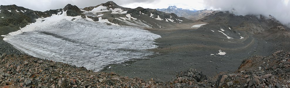
Retreated glacier on the Scalettahorn (left), east of the Scalettapass (right).


literature
- Martin Bundi: Scalettapass. In: Historical Lexicon of Switzerland . January 11, 2012 .
- Manfred Hunziker: Club Guide, Bündner Alpen, Volume VI (From Septimer to Flüela). 3. Edition. Verlag des SAC, 2000, ISBN 3-85902-187-7 , p. 427.
- Vital Eggenberger: Ski tours Graubünden South. Verlag des SAC, 2010, ISBN 978-3-85902-301-7 , p. 216.
- National map of Switzerland, sheet 1217 Scalettapass, 1: 25000, Federal Office of Topography, 2011 edition.
Web links
Individual evidence
- ↑ Martin Bundi: Scalettapass. In: Historical Lexicon of Switzerland . January 11, 2012 .
- ↑ Hiking Switzerland: Via Valtellina cultural and historical hiking trail ( Memento of the original from January 12, 2016 in the Internet Archive ) Info: The archive link was inserted automatically and has not yet been checked. Please check the original and archive link according to the instructions and then remove this notice.
Albrun | Antrona | Augstbord | Balme | Barna | Bocchetta di Val Maggia | Boeuf | Bunder bark | Carmenna | Carnusa | Casanna | Chaschauna | Chésery | Cheville | Chräzeren | Chrüzli | Corno | Cristallina | Cou | Diesrut | Durand | Duranna | Encel | Euschels | Ferret Grand | Ferret Petit | Foo | Fórcola | Fuorcla Surlej | Fuorcla da Patnaul | Furcletta | Futschöl | Goat path | Gemmi | Giümela | Gredigs Fürggli | Greina | Semolina | Grünenberg | Güner Lückli | Gurin Furggu | Heidel | Heubützli | Hörnligrat | Illsee | Yoke | Jorat | Kinzig | Boxes | Kleine Scheidegg | Lona | Soldering | Lys | Maienfelder Furgga | Meidpass | Menouve | Monte Moro | Muretto | Naret | Niemet | Panixer | Pontimia | Rawil | Redorta | Riseten | Rotstein | Saas | Safierberg | Saflish | San Giacomo | San Jorio | Saddle | Scaletta | Schlappiner yoke | Schnidejoch | Schonegg | Schwialp | Segnes | Septimer | Sertig | Soladier | Soreda | Stallerberg | Strela | Surene | Susanfe | Tamier | Theodule | Tomül | Torrent | Trescolmen | Trütlisberg | Urdenfürggli | Valserberg | Zeblasjoch | Between mountains