
Brail


Brail ( ) is a fraction of the Lower Engadine municipality of Zernez at 1636 m above sea level. M.
geography

Brail itself is geographically part of the Lower Engadine, but linguistically and culturally it is already part of the Upper Engadine . This comes from the Rhaeto-Romanic dialect , the turkey , which is spoken by almost all 112 (as of 2012) locals and which ends immediately behind Brail in favor of the Vallader .
On the other hand, since the Romansh language is still stronger in the Lower Engadine than in the Upper Engadine, Brail is economically and culturally oriented towards Zernez despite the dialect border.
traffic
Technically traffic Brail is the Engadine Kantonstrasse and through the station Cinuos-chel / Brail to the of Pontresina to Scuol leading Engadine line of Rhätischen web connected.
The Punt Ota on the border with Cinuos-chel is reserved for non-motorized traffic .
Attractions
The listed Reformed village church is worth seeing .
economy
In the south, Brail borders the Swiss National Park and lives largely from summer and winter tourism.
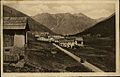
gallery

Postcard from 1923, seen coming from Zernez
Postcard from 1924, seen coming from Cinuos-chel


Web links
Coordinates: 46 ° 39 ' N , 10 ° 2' E ; CH1903: 798,580 / 170244