
Loetschberg
| Lötsche (n) pass | |||
|---|---|---|---|
 Lötschenpasshütte after renovation, summer 2008; |
|||
| Compass direction | north | south | |
| Pass height | 2684 m above sea level M. | ||
|
|
|
|
|
| Watershed | Kander | Lonza | |
| Valley locations | Kandersteg | Ferden | |
| expansion | Mule track | ||
| Mountains | Bernese Alps | ||
| map | |||
|
|||
| Coordinates | 621 379 / 140595 | ||

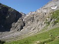
The Lötschberg is an alpine crossing in Switzerland between the Kandertal in the canton of Bern and the Lötschental in the canton of Valais . There is no summit called Lötschberg. Originally the Lötschenpass (apex 2690 m above sea level ), also: Lötschepass (saddle point 2684 m above sea level ) was equated with the Lötschberg. The path leads from the Gastern Valley in the Bernese Oberland to Ferden in the Valais and is only accessible on foot; on both sides you are in the Bernese Alps .
Lötschberg tunnel
Today “Lötschberg” is used to denote either the Lötschberg tunnel from 1913, a 14.6 km long railway tunnel from Kandersteg to Goppenstein , or the Lötschberg base tunnel from 2007, a 34.6 km long railway tunnel from Frutigen to Raron . The new Lötschberg base tunnel, part of the NEAT project, lowers the top of the railway line from 1240 m to 825 m . The Lötschbergbahn line and its continuation through the Simplon is the second most important alpine passage in Switzerland after the Gotthard .
The Lötschberg is also a connection for road traffic with car loading from Kandersteg to Goppenstein through the Lötschberg tunnel (continued through the Simplon tunnel to Iselle ).
Lötschenpass
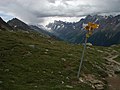
In summer, the traditional ascent route runs from the south through the lower Lötschental via Goppenstein to Wiler, following the Lonza . This is where the major ascent begins and leads first to the Lauchernalp and then over the Lötschenpass hut to the top of the pass. It is manned continuously from mid-January. You descend via Selden into the Gastern Valley and then follow the Kander via Kandersteg into the Bernese Oberland . In winter the Lötschenpass can be reached with the gondola lift via Hockenhorngrat.
Even in prehistoric times, people committed the pass, as is shown by finds from the Bronze and Iron Ages . From Roman times to the Middle Ages, the Lötschenpass was the most important link between the Bernese Oberland and the Valais, along with the Gemmi pass . As a trade route, it was particularly important as an extension of the Simplon route coming from northern Italy to northern Switzerland. The travelers and traders brought modest prosperity to the places on the ascent route.
Lötschen glacier eruption

marked hiking trail over the Lötschen glacier

Middle part of the glacier

Ascent to the Lötschenpass from the Gasterntal


Lötschenpasshütte and military cable car
In 1519 the first hut was built at the top of the mule track . In the 17th century, the Bernese began building a road over the pass. Religious conflicts between Bernese and Valais, however, led to a rift and meant the end of the construction work. Remains of the partially completed road can be seen on the north side of the pass. In the period that followed, the Alpine crossing, which was only accessible on foot, increasingly lost its importance.
In the 19th century, the Swiss army set up a guard on the pass and later two military barracks on the lateral moraine of the Lötschen glacier ( 2500 m above sea level ).
During the Second World War , the 3rd Division ("Kampfgruppe Hochalpen") built the MSB69 military cable car with the three sections: Changewasser (Selden, Gasterntal) ( 1535 m above sea level ) - Gfelalp ( 1847 m above sea level ) - Leckboden ( 2000 m above sea level ) - Mannli terminus at the Lötschen glacier at 2500 m above sea level. M.
In 1947, the two military barracks were carried by the Lötschental youth to their current location on the Lötschenpass and assembled into the Lötschenpasshütte , managed and later gradually expanded.
Descent into the Lötschen valley with a view of the Lötschenlücke and the Lang glacier

Descent to Lauchernalp with the Bietschhorn in the background


Others

The Lötschberg paddle steamer has been operating on Lake Brienz since 1914 .
Web links
- Klaus Aerni: Lötschenpass. In: Historical Lexicon of Switzerland .
- Lötschenpasshütte
- BLS car loading
Individual evidence
- ↑ a b Spelling & height according to SwissTopo (maps of Switzerland)
- ↑ Fortress Oberland: The southern front of the 3rd Division in the Reduit
- ↑ Lötschenpass: History
Albrun | Antrona | Augstbord | Balme | Barna | Bocchetta di Val Maggia | Boeuf | Bunder bark | Carmenna | Carnusa | Casanna | Chaschauna | Chésery | Cheville | Chräzeren | Chrüzli | Corno | Cristallina | Cou | Diesrut | Durand | Duranna | Encel | Euschels | Ferret Grand | Ferret Petit | Foo | Fórcola | Fuorcla Surlej | Fuorcla da Patnaul | Furcletta | Futschöl | Goat path | Gemmi | Giümela | Gredigs Fürggli | Greina | Semolina | Grünenberg | Güner Lückli | Gurin Furggu | Heidel | Heubützli | Hörnligrat | Illsee | Yoke | Jorat | Kinzig | Boxes | Kleine Scheidegg | Lona | Soldering | Lys | Maienfelder Furgga | Meidpass | Menouve | Monte Moro | Muretto | Naret | Niemet | Panixer | Pontimia | Rawil | Redorta | Riseten | Rotstein | Saas | Safierberg | Saflish | San Giacomo | San Jorio | Saddle | Scaletta | Schlappiner yoke | Schnidejoch | Schonegg | Schwialp | Segnes | Septimer | Sertig | Soladier | Soreda | Stallerberg | Strela | Surene | Susanfe | Tamier | Theodule | Tomül | Torrent | Trescolmen | Trütlisberg | Urdenfürggli | Valserberg | Zeblasjoch | Between mountains