Long glacier
| Long glacier | ||
|---|---|---|
|
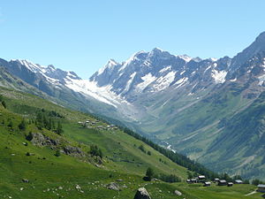
Lötschenlücke and Langgletscher from the southwest, from the Lauchernalp |
||
| location | Upper Lötschental , Canton of Valais , Switzerland | |
| Mountains | Bernese Alps | |
| Type | Valley glacier | |
| length | 6.5 km (2011) | |
| surface | 10.03 km² (1993) | |
| Exposure | southwest | |
| Altitude range | 3890 m above sea level M. - 2077 m above sea level M. (2005) | |
| Tilt | ⌀ 23.2 ° (43%) | |
| Ice volume | 0.64 ± 0.16 km³ (1993) | |
| Coordinates | 637 323 / 145029 | |
|
|
||
| drainage | Lonza , Rhone | |
The Langgletscher is a valley glacier at the head of the Lötschental in the southern Bernese Alps . It is located in the Swiss municipality of Blatten in the canton of Valais . The glacier with a pronounced tongue was in 1973 with an area of 10.1 km² about 6.9 km long. By 2010, interrupted by an advance in the 1980s, its length has been shortened by more than 400 meters. Since the high stage during the Little Ice Age around the middle of the 19th century, the Lang glacier has receded by around one kilometer.
The long glacier arises from two source glaciers , the larger of which is called Anunletscher (also Anengletscher) and originates on the southern flank of the glaciated Mittaghorn at 3890 m above sea level. M. has. It flows as a one kilometer wide ice stream with a steep gradient southwards down the slope. The second arm begins at the Lötschenlücke , a 3170 m high glaciated mountain pass, and flows southwest along the northern foot of the Schinhorn . In its lower part, the Lang glacier is only around 500 m wide. The glacier tongue, which is for the most part covered by bed load, lies at around 2100 m . The glacier drains into the Lonza , which flows through the Lötschental to the Rhone .
On a ledge of the Anengrat , which separates the Lang glacier from the system of the Aletsch glacier in the east, the Hollandia hut of the Swiss Alpine Club SAC stands at 3240 m above sea level near the Lötschenlücke . M. It serves as an important stage on extensive glacier tours on the route from Lötschental to Jungfraujoch , or further east to the Grimsel Pass .
The glacier foreland of the Lang glacier is an object of the Swiss inventory of this type of landscape of national importance.
Web links
- Langgletscher on the ETHorama platform
- Map section at map.geo.admin.ch
- Interactive before and after comparison pictures of the Lang glacier
Individual evidence
- ↑ a b Research Institute for Hydraulic Engineering, Hydrology and Glaciology (VAW) of the ETH Zurich (Ed.): Langgletscher. In: Swiss Glacier Measurement Network. ( ethz.ch , also as PDF , accessed on January 27, 2014).
- ↑ a b Daniel Farinotti, Matthias Huss, Andreas Bauder, Martin Funk: An estimate of the glacier ice volume in the Swiss Alps. In: Global and Planetary Change. 68: 225-231, 2009 ( online ; PDF; 756 kB).
- ^ WGMS: Fluctuations of Glaciers Database. World Glacier Monitoring Service, Zurich 2013 ( DOI: 10.5904 / wgms-fog-2013-11 ), accessed on December 11, 2013
- ↑ Andreas Linsbauer, Frank Paul, Wilfried Haeberli: Modeling glacier thickness distribution and bed topography over entire mountain ranges with GlabTop: Application of a fast and robust approach. In: Journal of Geophysical Research. , Volume 117, F03007, 2012, doi : 10.1029 / 2011JF002313 ( online )

