
Grimsel Pass
| Grimsel Pass | |||
|---|---|---|---|
 View from the canton border to the top of the pass and Totesee towards the east. |
|||
| Compass direction | North | south | |
| Pass height | 2164 m above sea level M. | ||
| Canton |
|
|
|
| Watershed | Aare > Rhine | Rhone | |
| Valley locations | Innertkirchen , Guttannen | Glacier | |
| expansion | Street | ||
| Built | 1894 | ||
| Winter closure | October - May | ||
| Mountains |
Bernese Alps (West) Urner Alps (East) |
||
| profile | |||
| Ø pitch | 5.9% (1540 m / 26 km) | 6.8% (408 m / 6 km) | |
| Max. Incline | 11% | 9% | |
| map | |||
|
|||
| Coordinates | 668 858 / 157041 | ||

The Grimsel Pass is a Swiss mountain pass that connects the Bernese Oberland with the Upper Valais and separates the Bernese from the Urner Alps . Within Switzerland it is often referred to in short as (the) Grimsel, less often in the male form (the Grimsel). The pass height (canton border) is 2164 m above sea level. M. on the European watershed between the Mediterranean and the North Sea . The historic mule track was expanded into a modern high alpine road in the 19th century, which is open in summer; its apex is only a little northeast on the Valais side ( 2164 m above sea level )
history
The first documented use of the Grimsel Pass for mule traffic dates from the 14th century. Use during Roman times and a crossing in 1211 by the Duke of Zähringen's troops are not guaranteed. In 1397 the regions of Pomatt , Goms and Hasli as well as the cities of Unterseen , Thun and Bern concluded an agreement in which they agreed to ensure free and safe trade and to maintain the mule track over the Grimsel (mule track). Many traces of the historic mule track along the Aare and from the top of the pass into Goms have been preserved.
The expansion of the mule track into a modern pass road took place relatively late compared to other Swiss pass crossings. The new road was completed in 1894. As a result of the construction of the hydropower plants by Kraftwerke Oberhasli AG in this area, the road was expanded between 1920 and 1950 and some of it was rebuilt.
For several decades there were frequent rockfalls on the Grimsel Pass road between Innertkirchen and Guttannen . At times the night driving ban was in effect in this area of the pass road and Grimsel traffic was diverted via Understock . Because a rock outcrop called Chapf got into an unstable position 900 meters above the road, the federal authorities decided to blast the Fluh in a controlled manner. On October 4, 2001, the chapf was blown away after months of drilling. With 150,000 cubic meters of loosened rock, this was the largest blast in Switzerland to date.
Lakes


On the north side there are three reservoirs connected by tunnels . Ascending according to their altitude, these are the Räterichsbodensee , the Grimselsee and the Oberaarsee . The Räterichsbodensee and the Grimselsee are located directly on the pass road. The Gelmersee reservoir is also located in the northern Grimsel area . The reservoirs are operated by the Oberhasli power plants . The Totesee lies at the top of the pass .
On the valley side of the Räterichsbodensee dam, the large-format picture of the water maiden Mélisande by the artist Pierre Mettraux was completed in September 2007 . The Hotel Grimselhospiz is located on a peninsula in the Grimselsee below the top of the pass.
Street

On the north side, the pass road begins as part of the main road 6 coming from the Jura in the Haslital about two kilometers after leaving the village in the south of Innertkirchen . At this point the road is not very steep, but it rises steadily. 9 km after Innertkirchen you reach Guttannen , which is located at 1060 m (Innertkirchen 625 m). After Guttannen, the road climbs again with approximately the same gradient until you reach Handegg after six kilometers.
From there you can take the steepest funicular in the world, the Gelmerbahn , to reach Lake Gelmer . After the Handegg the road runs in a comparatively steep S-curve and into one of the numerous tunnels. Then you are above the tree line and after a few switchbacks you reach the Räterichsbodensee.
The road runs for a while here by the lake, until it again climbs in serpentines with a steep incline to the Grimselsee. The hospice is located here. The road climbs quite steeply again, there are still six switchbacks (150 meters in altitude) to the top of the pass. At the top of the pass there are three hotels and a smaller lake, the Totesee.
On the south side the road climbs steeply from Oberwald and runs through spruce forest to Gletsch at the tree line. There the road branches off from Hauptstrasse 19 , which continues on to the Furkapass. The Grimselpassstrasse now runs steeply in steady serpentines to the top of the pass. In the opposite direction you have a view of the Goms , the slightly higher Furka Pass and in the distance the Valais Alps .
The Grimselpassstrasse is part of the Aare route , Switzerland's national cycle route 8. The pass road climbs briefly but steeply on the south side, while on the north side it rises with a maximum of 9% and has a length of 26 km.
Climate table
| Grimsel Hospiz (1980 m above sea level), 1981-2010 | ||||||||||||||||||||||||||||||||||||||||||||||||
|---|---|---|---|---|---|---|---|---|---|---|---|---|---|---|---|---|---|---|---|---|---|---|---|---|---|---|---|---|---|---|---|---|---|---|---|---|---|---|---|---|---|---|---|---|---|---|---|---|
| Climate diagram | ||||||||||||||||||||||||||||||||||||||||||||||||
| ||||||||||||||||||||||||||||||||||||||||||||||||
|
Average monthly temperatures and precipitation for Grimsel Hospiz (1980 m above sea level), 1981–2010
Source:
|
||||||||||||||||||||||||||||||||||||||||||||||||||||||||||||||||||||||||||||||||||||||||||||||||||||||||||||||||||||||||||||||||||||||||||||||||||||||||||||||||||||||||||||||||||||
The maximum value for the average temperature in January was reached in 2020 at −1.4 ° C. This broke the previous record of 1989 (−1.7 ° C).
Tour de Suisse
The Grimsel Pass has been on the Tour de Suisse program ten times : 1937, 1953, 1956, 1962, 1973, 1986, 1996, 2002, 2007 and 2011. It was the destination for the seventh stage in 2007. The Grimsel ranks as the eighth highest pass that the tour crossed (as of November 2011, altitude rating until 2010).
Grimsel rock laboratory
Nagra's Grimsel rock laboratory is located in the area of the pass and the power plants , where experiments on crystalline rock are carried out to research the disposal of radioactive waste.
photos
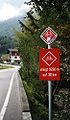
Sign in Innertkirchen at the north approach to the pass

The dam of the Räterichsbodensee with the Mélisande picture
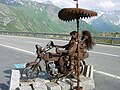
Art at the top of the pass
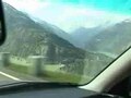
On the pass road (2004)


See also
literature
- Hans von Rütte: Grimsel Pass. In: Historical Lexicon of Switzerland . January 30, 2006 .
Web links
- Profile of the north side on salite.ch
- Grimsel Pass on the ETHorama platform
Individual evidence
- ↑ Contribution by Swiss television to the demolition ( memento of the original from November 10, 2013 in the Internet Archive ) Info: The archive link was automatically inserted and not yet checked. Please check the original and archive link according to the instructions and then remove this notice. (accessed on August 23, 2013)
- ↑ Climate table. In: meteoschweiz.admin.ch. meteoschweiz, accessed on June 1, 2018 .
- ↑ Felix Blumer: Records in January - records for temperature and sunshine duration. In: srf.ch . February 1, 2020, accessed February 4, 2020 .
- ↑ Grimsel rock laboratory
Ächerli • Agites • Aiguillon • Albis • Albula • Balmberg • Benkerjoch • Bernina • Böhler • Bözberg • Breitehöchi • Brünig • Buechenegg • Bürersteig • Chall • Challhöchi Pass • Champex • Chasseral • Chatzenstrick • Chilchzimmersattel • Croix • Croix • Croix de Coeur • Eichhöhe • Étroits • Etzelpass • Flüela • Forclaz • Furka • Ghöch • Givrine • glass • Glaubenberg • Glaubenbielen • Gottschalkenberg • Grimsel • Grosse Scheidegg • Gr.St.Bernhard • Gurnigel • Haggenegg • Hahnenmoos • Heitersberg • Hilferen • Hirzel • Hirzel Höhi • Hulftegg • Ibergeregg • Jaman • Jaun • Julier • Kerenzerberg • Klausen • Kunkels • Lein • Lenzerheide • Livigno • Lukmanier • Maloja • Marchairuz • Mollendruz • Mont Crosin • Monte Ceneri • Mont d'Orzeires • Montvoie • Morgins • Mosses • Mutschellen • Neggia • Nufenen • Oberalp • upper Hauenstein • Oberricken • oven • Orn • Passwang • Pierre Pertuis • Pillon • Planches • Pontins • Pragel • edge crossing • Rangiers • rates • Rengg • crocheted • Roches • 'groups • R üsler • Saanenmöser • Salhöhe • San Bernardino • Sanetsch • Santelhöchi • Sattel • Sattelegg • Schafmatt • Schallenberg • Schelten • Schönau • Schufelberger Egg • Schwägalp • Schwarzenbühl • Siblingerhöhe • Simplon • Splügen • St. Anton • St. Gotthard • St. Luzisteig • Staffelegg • Stoss • Susten • Tourne • Tronc • Umbrail • Unterer Hauenstein • Front Höhi • Vue des Alpes • Wasserfluh • Weissenstein • Wildhaus • Wissegg • Wolfgang