
Buechenegg
| Buechenegg | |||
|---|---|---|---|
 In front Restaurant Chusperhüsli, in the back Restaurant Buchengg |
|||
| Compass direction | east | west | |
| Pass height | 786 m above sea level M. | ||
| Canton | Zurich | ||
| Valley locations | Langnau am Albis | Tägerst | |
| expansion | Street | ||
| Lock | - | ||
| profile | |||
| Ø pitch | 10.0% (250 m / 2.5 km) | 8.0% (200 m / 2.5 km) | |
| Max. Incline | 12% | 12% | |
 |
|||
| Map (Switzerland) | |||
|
|||
| Coordinates | 680 866 / 238847 | ||

The Buchenegg (also: Buchenegg) is a pass in the Swiss canton of Zurich . It connects the places Langnau am Albis and Stallikon (hamlet of Tägerst). The pass is at 786 m. The hiking trail runs over the Buchenegg over the Albis ridge . Two restaurants offer catering. The place is not connected to the public transport network.

Buecheneggstrasse Albis south side with the hamlet Tobel

Chnusperhüsli restaurant
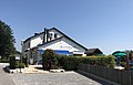
Buchenegg restaurant


Web links
Individual evidence
Ächerli • Agites • Aiguillon • Albis • Albula • Balmberg • Benkerjoch • Bernina • Böhler • Bözberg • Breitehöchi • Brünig • Buechenegg • Bürersteig • Chall • Challhöchi Pass • Champex • Chasseral • Chatzenstrick • Chilchzimmersattel • Croix • Croix • Croix de Coeur • Eichhöhe • Étroits • Etzelpass • Flüela • Forclaz • Furka • Ghöch • Givrine • glass • Glaubenberg • Glaubenbielen • Gottschalkenberg • Grimsel • Grosse Scheidegg • Gr.St.Bernhard • Gurnigel • Haggenegg • Hahnenmoos • Heitersberg • Hilferen • Hirzel • Hirzel Höhi • Hulftegg • Ibergeregg • Jaman • Jaun • Julier • Kerenzerberg • Klausen • Kunkels • Lein • Lenzerheide • Livigno • Lukmanier • Maloja • Marchairuz • Mollendruz • Mont Crosin • Monte Ceneri • Mont d'Orzeires • Montvoie • Morgins • Mosses • Mutschellen • Neggia • Nufenen • Oberalp • upper Hauenstein • Oberricken • oven • Orn • Passwang • Pierre Pertuis • Pillon • Planches • Pontins • Pragel • edge crossing • Rangiers • rates • Rengg • crocheted • Roches • 'groups • R üsler • Saanenmöser • Salhöhe • San Bernardino • Sanetsch • Santelhöchi • Sattel • Sattelegg • Schafmatt • Schallenberg • Schelten • Schönau • Schufelberger Egg • Schwägalp • Schwarzenbühl • Siblingerhöhe • Simplon • Splügen • St. Anton • St. Gotthard • St. Luzisteig • Staffelegg • Stoss • Susten • Tourne • Tronc • Umbrail • Unterer Hauenstein • Front Höhi • Vue des Alpes • Wasserfluh • Weissenstein • Wildhaus • Wissegg • Wolfgang