
Oberalp Pass
| Oberalp Pass | |||
|---|---|---|---|
 Oberalppass, Graubünden side |
|||
| Compass direction | east | west | |
| Pass height | 2044 m above sea level M. | ||
| Canton | Grisons | Uri | |
| Watershed | Vorderrhein | Oberalpreuss | |
| Valley locations | Sedrun | Andermatt | |
| expansion | Pass road / railway | ||
| Built | 1862-1863 | ||
| Winter closure | November - May | ||
| particularities | Car loading in winter | ||
| profile | |||
| Denzel scale | SG 2 | SG 2 | |
| Ø pitch | 4.4% (914 m / 20.9 km) | 5.6% (597 m / 10.7 km) | |
| map | |||
|
|||
| Coordinates | 694 337 / 168239 | ||

The Oberalp Pass ( Rhaeto-Romanic or ) connects the two Swiss villages of Disentis / Mustér in the Surselva in the canton of Graubünden with Andermatt in the Urserental in the canton of Uri .
location

The pass is at 2044 m above sea level. M. in the municipality of Tujetsch . Immediately west of the top of the pass is the slightly dammed Oberalpsee. To the southwest rises the Pazolastock ( 2739 m above sea level ), in the east the Calmut ( 2310 m above sea level ), north of this the Piz Tiarms ( 2917 m above sea level ), to the west of this the Schneehüenerstock ( 2772 m above sea level ) above sea level ), which is used for military purposes and accessed by a gondola , as well as the Brunnenstock ( 2,887 m above sea level ).
Between Calmut and Piz Tiarms is the Tiarms pass ( 2148 m above sea level ), which also leads to Rueras via Milez . The Fellilücke ( 2476 m above sea level ), via which Gurtnellen can be reached, lies between Piz Tiarmsund Schneehüenerstock .
Lai da Tuma (Lake Toma, 2345 m ) is three kilometers south of the pass . It is considered the source of the Rhine ( Vorderrhein , Rein Anteriur ). The outflow from the lake is called Rein da Tuma . This and a few other tributaries become the Vorderrhein after the first two valley steps before Tschamut .
Development
The Matterhorn-Gotthard-Bahn crosses the pass in a short tunnel, making it the only railway line in Switzerland alongside the Bernina Railway that does not require a long tunnel at such an altitude. The Furka-Oberalp-Bahn started operating over the pass in 1926.
In the years 1862/63 the first road was built over the pass. The main road 19 , which leads over the pass, will be closed in winter. The opening times of the pass vary depending on the snow conditions from mid-April to early December at the latest. A limited number of vehicles can be transported between Andermatt and Sedrun in winter by car transport.
tourism
The Senda Sursilvana long-distance hiking trail leads over the Oberalp Pass and along the young Vorderrhein in the Surselva to the end of the Rhine Gorge near Tamins, the confluence of the Vorderrhein and Hinterrhein.
In winter, alpine skiers, snowshoeers and touring skiers are active from the top of the pass. A ski lift leads via the Calmut to the Sedrun ski area, a gondola lift leads under the summit of the Schneehüenerstock . This 10-seater gondola lift is the heart of the ski area connection from Sedrun to Andermatt and was opened in December 2018.
The Rheinquelle lighthouse , a scaled-down replica of the 14 meter high tower that stood for 70 years in Hoek van Holland at the mouth of the Rhine, has stood at the top of the pass since October 2010 . It is a tourist advertising campaign that was developed on behalf of Sedrun Disentis Tourism and Switzerland Tourism. The campaign is intended to advertise the holiday region along the Rhine. One day, the old Rhine freighter “Rheinquelle” will also be added, which will be transported overland from Basel, but will serve as an ambassador for the Rhine at as many places as possible along the river from Rotterdam. The implementation of this idea has so far failed (as of 2014) due to the financing and logistics.

Oberalppasshöhe with Rheinquelle lighthouse
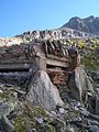
Former bunker over the pass at the Fellilücke ( 2476 m )
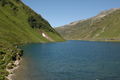
Oberalpsee

Restaurants at the top of the pass, with Schneehüenerstock

Around 1900, to the west

Construction of the new pass road near Andermatt, 1969


literature
- Jürg Simonett: Oberalp Pass. In: Historical Lexicon of Switzerland . April 29, 2010 .
Web links
- Oberalppass on the ETHorama platform
- Rheinquelle Lighthouse Foundation
Individual evidence
- ↑ Oberalpsee on ETHorama
- ^ National map of Switzerland, sheet 1232 Oberalppass, 1: 25000, Federal Office for Topography, 2005 edition
- ^ Charles Knapp, Maurice Borel, Victor Attinger, Heinrich Brunner, Société neuchâteloise de geographie (editor): Geographical Lexicon of Switzerland . Volume 3: Krailigen - Plentsch . Verlag Gebrüder Attinger, Neuenburg 1905, p. 618 f., Keyword Oberalppass ( scan of the lexicon page ).
- ↑ Statistical opening times of the pass over the past few years
- ↑ Southeastern Switzerland
- ↑ medi cine medienproduktions gmbh: Rheinquelle ( Memento of the original from October 31, 2013 in the Internet Archive ) Info: The archive link was inserted automatically and has not yet been checked. Please check the original and archive link according to the instructions and then remove this notice.
- ↑ The lighthouse on sonntagszeitung.ch/read/sz_13_07_2014/kultur
Ächerli • Agites • Aiguillon • Albis • Albula • Balmberg • Benkerjoch • Bernina • Böhler • Bözberg • Breitehöchi • Brünig • Buechenegg • Bürersteig • Chall • Challhöchi Pass • Champex • Chasseral • Chatzenstrick • Chilchzimmersattel • Croix • Croix • Croix de Coeur • Eichhöhe • Étroits • Etzelpass • Flüela • Forclaz • Furka • Ghöch • Givrine • glass • Glaubenberg • Glaubenbielen • Gottschalkenberg • Grimsel • Grosse Scheidegg • Gr.St.Bernhard • Gurnigel • Haggenegg • Hahnenmoos • Heitersberg • Hilferen • Hirzel • Hirzel Höhi • Hulftegg • Ibergeregg • Jaman • Jaun • Julier • Kerenzerberg • Klausen • Kunkels • Lein • Lenzerheide • Livigno • Lukmanier • Maloja • Marchairuz • Mollendruz • Mont Crosin • Monte Ceneri • Mont d'Orzeires • Montvoie • Morgins • Mosses • Mutschellen • Neggia • Nufenen • Oberalp • upper Hauenstein • Oberricken • oven • Orn • Passwang • Pierre Pertuis • Pillon • Planches • Pontins • Pragel • edge crossing • Rangiers • rates • Rengg • crocheted • Roches • 'groups • R üsler • Saanenmöser • Salhöhe • San Bernardino • Sanetsch • Santelhöchi • Sattel • Sattelegg • Schafmatt • Schallenberg • Schelten • Schönau • Schufelberger Egg • Schwägalp • Schwarzenbühl • Siblingerhöhe • Simplon • Splügen • St. Anton • St. Gotthard • St. Luzisteig • Staffelegg • Stoss • Susten • Tourne • Tronc • Umbrail • Unterer Hauenstein • Front Höhi • Vue des Alpes • Wasserfluh • Weissenstein • Wildhaus • Wissegg • Wolfgang