
Pragel Pass
| Pragel Pass | |||
|---|---|---|---|
 Chapel south of the pass, view to the north |
|||
| Compass direction | Northeast | southwest | |
| Pass height | 1548 m above sea level M. | ||
| Canton | Glarus | Schwyz | |
| Watershed | Chlü , Löntsch , Linth ( Rhine ) | Starzlen, Muota , Lake Lucerne ( Rhine ) | |
| Valley locations | Riedern | Muotathal | |
| expansion | Pass road (mostly single lane) | ||
| Built | 1970-1974 | ||
| Winter closure | October - June | ||
| Mountains | Alps | ||
| particularities | Vehicle lock on the east ramp on weekends | ||
| profile | |||
| Denzel scale | SG 2-3 | SG 3 | |
| Ø pitch | 4.9% (1039 m / 21.32 km) | 7.8% (940 m / 12 km) | |
| Max. Incline | 14% | 18% | |
| Map (Schwyz) | |||
|
|||
| Coordinates | 708 818 / 206 337 | ||

The Pragelpass is a mountain pass in Switzerland that connects the Muotatal in the canton of Schwyz with the Klöntal in the canton of Glarus .
location
The Pragelpass lies between the places Muotathal and Riedern , the pass height is 1548 m above sea level. M. , west of it the Drusberg ( 2282 m above sea level ), east of the Pragel ( 2319 m above sea level ). The road is mostly single-lane and climbs sharply, especially from Schwyz (up to 18%), then leads past the Klöntalersee on the Glarus side .
The road runs parallel to the Klausenpass at a much lower altitude. Nevertheless, the winter closure at the Pragel Pass lasts longer.
There are several traffic restrictions (exceptions for agriculture): only vehicles up to 3.5 tons and without a trailer are permitted, and on the approx. 2 km short stretch between Richisau and the canton border GL / SZ (about halfway between Klöntalersee and the pass summit ) there is a driving ban for motor vehicles on Saturdays and Sundays. This means that the route cannot be used as a connection between the Glarus region and central Switzerland on weekends.
On the Schwyzer side, the road leads through a forest that has been left in its natural state since Hurricane Lothar ; one of the few primeval forests in Europe. The top of the pass is ideal as a starting point for a hike to the Silberen , a karst landscape that is unique in Switzerland .
history
At the beginning of October 1799, Generalissimo Alexander Wassiljewitsch Suworow crossed the pass with an army of between 15,000 and 20,000 men in the Second Coalition War . Between 1766 and 1908 several attempts to build a road over the pass failed, and the project for a narrow-gauge railway from 1911 remained unrealized.
In 1940 today's pass road was built on the Glarus side, the Schwyz part followed in 1974. The road construction was carried out by genius units of the Reduit Brigade 24 for military reasons. The initiator and person responsible for the construction was Claus Cramer, the commander of the brigade, who received honorary citizenship from the Muotathalers.
During the Second World War , the pass, as part of the Rochade axis Weisstannental –Muotathal, was made safe in winter with military cable cars in the event of a lasting destruction of the Kerenzerberg axis (road and rail) and completed in spring 1940. It should enable ammunition and food supplies for the Sargans fortress area from the central area as well as the transport of the wounded from the Lochezen military hospital to military hospitals in central Switzerland. The 13-kilometer-long MSB101 military cable car ran in three sections from Richisau ( 1192 m above sea level ) to the Pragel Pass and to Gutentalboden ( 1297 m above sea level ) in the Muotathal.
traffic
A short section of the eastern ramp (from Richisau to the canton border between Glarus and Schwyz) has been closed to motor vehicle traffic on weekends since 1978 in order to prevent through-traffic at the weekend.
From August 2008 and in 2009 the Pragelbus ran several times a day between Hölloch and Richisau in summer, and only on weekends in the second year in the off-season. In December 2009 the offer was discontinued for cost reasons.

Pass height

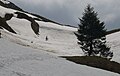
Pragelpass plateau, general view towards south
Pragelpass at the end of May, shortly before the top of the pass from the Glarus side;


literature
- Harald Denzel (Ed.): Great Alpine Road Guide . 23rd edition. Denzel Verlag, Innsbruck 2007, ISBN 978-3-85047-766-6 .
Web links
- Karin Marti-Weissenbach: Pragel Pass. In: Historical Lexicon of Switzerland .
- Inclination diagram of the Riedern driveway
- Inclination diagram of the driveway from the Klöntalersee
- Inclination diagram of the driveway from Muotathal
- History of the Pragel Pass 1900–1981
- Road conditions of the Pragel Pass (municipality of Muotathal)
- Silberen karst trail on wanderland.ch
Individual evidence
- ↑ NZZ of September 14, 2001: Bödmeren Primeval Forest Reserve ( Memento of May 28, 2015 in the Internet Archive )
- ↑ Hans Stadler-Planzer: Military monuments in Uri, Schwyz and Zug. Historical overview ( memento of the original from May 9, 2016 in the Internet Archive ) Info: The archive link was inserted automatically and has not yet been checked. Please check the original and archive link according to the instructions and then remove this notice. . In: Federal Department of Defense, Civil Protection and Sport (ed.): Military monuments in the cantons of Uri, Schwyz and Zug. Inventory of the combat and command structures. (pdf, 2.0 MB) pp. 4–7, here p. 6.
- ↑ Pragelbus timetable. (pdf, folder; 438 kB) (No longer available online.) AAGS , archived from the original on March 4, 2016 ; Retrieved December 28, 2009 . Info: The archive link was inserted automatically and has not yet been checked. Please check the original and archive link according to the instructions and then remove this notice.
- ↑ Pragelbus - a victim of the crisis. (No longer available online.) In: Bote der Urschweiz . June 27, 2009, formerly in the original ; Retrieved December 28, 2009 . ( Page no longer available , search in web archives )
- ↑ Pragelbus not finished yet. (PDF; 127 kB) (No longer available online.) In: Bote der Urschweiz . October 8, 2009, formerly in the original ; Retrieved December 28, 2009 . ( Page no longer available , search in web archives ) Info: The link was automatically marked as defective. Please check the link according to the instructions and then remove this notice.
Ächerli • Agites • Aiguillon • Albis • Albula • Balmberg • Benkerjoch • Bernina • Böhler • Bözberg • Breitehöchi • Brünig • Buechenegg • Bürersteig • Chall • Challhöchi Pass • Champex • Chasseral • Chatzenstrick • Chilchzimmersattel • Croix • Croix • Croix de Coeur • Eichhöhe • Étroits • Etzelpass • Flüela • Forclaz • Furka • Ghöch • Givrine • glass • Glaubenberg • Glaubenbielen • Gottschalkenberg • Grimsel • Grosse Scheidegg • Gr.St.Bernhard • Gurnigel • Haggenegg • Hahnenmoos • Heitersberg • Hilferen • Hirzel • Hirzel Höhi • Hulftegg • Ibergeregg • Jaman • Jaun • Julier • Kerenzerberg • Klausen • Kunkels • Lein • Lenzerheide • Livigno • Lukmanier • Maloja • Marchairuz • Mollendruz • Mont Crosin • Monte Ceneri • Mont d'Orzeires • Montvoie • Morgins • Mosses • Mutschellen • Neggia • Nufenen • Oberalp • upper Hauenstein • Oberricken • oven • Orn • Passwang • Pierre Pertuis • Pillon • Planches • Pontins • Pragel • edge crossing • Rangiers • rates • Rengg • crocheted • Roches • 'groups • R üsler • Saanenmöser • Salhöhe • San Bernardino • Sanetsch • Santelhöchi • Sattel • Sattelegg • Schafmatt • Schallenberg • Schelten • Schönau • Schufelberger Egg • Schwägalp • Schwarzenbühl • Siblingerhöhe • Simplon • Splügen • St. Anton • St. Gotthard • St. Luzisteig • Staffelegg • Stoss • Susten • Tourne • Tronc • Umbrail • Unterer Hauenstein • Front Höhi • Vue des Alpes • Wasserfluh • Weissenstein • Wildhaus • Wissegg • Wolfgang