
Kunkelspass
| Kunkelspass | |||
|---|---|---|---|
 The top of the pass road seen from SE, on the far left Crap Mats |
|||
| Compass direction | north | south | |
| Pass height | 1347 m above sea level M. | ||
| Canton / State |
|
||
| Watershed | Tamina | Rhine | |
| Valley locations | Vattis | Tamins | |
| expansion | Driveway (driving ban for motor vehicles) | ||
| Built | in the First World War | ||
| Winter closure | November – April | ||
| Mountains | Glarus Alps | ||
| profile | |||
| Ø pitch | 5.2% (410 m / 7.9 km) | 10.9% (689 m / 6.3 km) | |
| Max. Incline | 12% | 19% | |
| map | |||
|
|||
| Coordinates | 750 400 / 191.28 thousand | ||

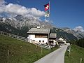
The Kunkelspass ( 1347 m above sea level ) is a mountain pass in the Glarus Alps south of the hamlet of Kunkels in the Swiss canton of Graubünden . It lies between the Crap Mats (2947 m) and the Calanda (2806 m). A subordinate watershed runs over it , between the Tamina in the north and the brook that flows south into the Alpine Rhine . The connection leads from Vättis in the Tamina valley in the north to Tamins in the Graubünden Rhine Valley and has a peak height of 1,358 m above sea level. M. , where there is a mountain restaurant.
geography
The Kunkelspass geologically marks the eastern edge of the Aar massif , which is opened up again at Vättis. It lies between the steeply sloping walls of the Calanda in the east and the mountain range around the Ringelspitz in the west. There are indications that the Kunkelspass should correspond to the prehistoric course of the Rhine. At the top of the pass is the Alp Überuf with a mountain inn.
history
Finds suggest that the mule track over the Kunkelspass was already crossed in Roman times. The name comes from the Latin concha , which means shell .
In later times it became important for the Pfäfers monastery , which owned numerous possessions in Graubünden. The Kunkel served as an alternative route when the Rhine Valley was not accessible during floods, or to bypass the customs stations there. The mule track also served as access to the Taminser's Maiensässen and for driving cattle to the southern markets.
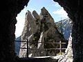
Today's narrow driveway with the promising tunnel on the Taminser side was built during the First World War.
traffic
The Kunkelspass is not cleared in winter, the drivable road, which is not covered with black pavement, leads on the south side through steep landslides and rubble. Driving with motor vehicles is only permitted with official approval.
tourism
Today the Kunkel is a popular hiking and biking destination. The round tour from Chur over the Kunkelspass is a classic bike ride with its beautiful viewpoints.
literature
- Elmar Good, Pier Hänni: Magical Graubünden. Hikes to places of power. AT-Verlag 2005, ISBN 3-85502-972-5 .
- Kunkels - a world of its own. The work and life of our ancestors on the Maiensäss. Local history work by Christian Jörimann, Tamins 1995.
- Jürg Simonett: Kunkelspass. In: Historical Lexicon of Switzerland . 2008 .
Web links
- Kunkelspass on the ETHorama platform
- Tourist website Kunkelspass
- Hike over the Kunkelspass

View over the Rhine valley to the Kunkelspass
Kunkelspass

Kunkelspass tunnel
Kunkelspass


Individual evidence
Albrun | Antrona | Augstbord | Balme | Barna | Bocchetta di Val Maggia | Boeuf | Bunder bark | Carmenna | Carnusa | Casanna | Chaschauna | Chésery | Cheville | Chräzeren | Chrüzli | Corno | Cristallina | Cou | Diesrut | Durand | Duranna | Encel | Euschels | Ferret Grand | Ferret Petit | Foo | Fórcola | Fuorcla Surlej | Fuorcla da Patnaul | Furcletta | Futschöl | Goat path | Gemmi | Giümela | Gredigs Fürggli | Greina | Semolina | Grünenberg | Güner Lückli | Gurin Furggu | Heidel | Heubützli | Hörnligrat | Illsee | Yoke | Jorat | Kinzig | Boxes | Kleine Scheidegg | Lona | Soldering | Lys | Maienfelder Furgga | Meidpass | Menouve | Monte Moro | Muretto | Naret | Niemet | Panixer | Pontimia | Rawil | Redorta | Riseten | Rotstein | Saas | Safierberg | Saflish | San Giacomo | San Jorio | Saddle | Scaletta | Schlappiner yoke | Schnidejoch | Schonegg | Schwialp | Segnes | Septimer | Sertig | Soladier | Soreda | Stallerberg | Strela | Surene | Susanfe | Tamier | Theodule | Tomül | Torrent | Trescolmen | Trütlisberg | Urdenfürggli | Valserberg | Zeblasjoch | Between mountains