Urdenfürggli
| Urdenfürggli | |||
|---|---|---|---|
|
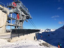
Urdenfürggli (deepest cut in the ridge) and Parpaner Schwarzhorn (right) in front of the construction of the Urdenbahn . View from the Hörnlihütte |
|||
| Compass direction | east | west | |
| Pass height | 2546 m above sea level M. | ||
| Canton | Graubünden , Switzerland | ||
| Watershed | Plessure | Rabiosa | |
| Valley locations | Tschiertschen / Arosa | Lenzerheide / Parpan | |
| expansion | Mountain hiking trail and cable cars | ||
| Mountains | Plessur Alps | ||
| map | |||
|
|
|||
| Coordinates | 764 977 / 181 663 | ||
The Urdenfürggli is an alpine pass in the Swiss canton of Graubünden . With a peak height of 2546 m above sea level. M. connects it via Urdental Tschiertschen and Arosa with Vaz / Obervaz and Parpan .
description
A marked hiking trail, which is often used in summer, leads across Urdenfürggli, which is located exactly between Parpaner Schwarzhorn and Weisshorn . This usually also serves as a southern ascent or descent route to the Schwarzhorn and, in conjunction with the Hörnligrat and the Gredigs Fürggli, offers a popular Hörnlihütte -Lenzerheide-Arosa circular tour in summer and winter . The also marked crossing 2559, located a little to the south, which opens up the same areas and is a shortcut from certain directions compared to the main pass, is not considered Urdenfürggli.
history
For the Walsers who had settled in Arosa since the beginning of the 14th century, the Urdenfürggli was the fastest and most important connection to the Rhaeto-Romanic Obervaz, to which they belonged until their own church in Langwies was built in 1384/85 despite the language barrier . In contrast, the Tschiertscher and Prader hardly ever used the pass, as the connection over the Churer Joch was and is more advantageous for them.
Until recently, traces of an old path, which was probably manageable for narrow wheeled carts, could still be seen between Hörnligrat and Urdenfürggli. It is unclear whether the mining previously operated in Arosa was partly responsible for this above-average standard of construction compared to the Carmenna , the Furcletta and the Maienfelder Furgga .
Tourist use

In 1911, an approximately one meter wide bridle path from Arosa to Lenzerheide and Parpan was created over the Urdenfürggli. Today the transition is mainly used by mountain hikers, mountain bikers and ski tourers. All accesses have a level of difficulty T2 . A continuation of the Schanfiggerstrasse from Arosa to Lenzerheide and a plan variant of the Arosabahn under the Urdenfürggli were not implemented.
As part of the Arosa - Lenzerheide ski area connection , the transition became the location of the western station of a pillarless connecting cable car ( Urdenbahn ) from the Hörnligrat . The connection was opened on January 18, 2014. In addition, the Urdenfürggli was opened up from the Motta with a new chairlift, which replaces the one to the Schwarzhorn. In the legendary and protected Urdental, no ski slopes or advanced lifts were built.
Sports event
Urdenfürggli has been a transit point for the Swiss Irontrail since 2014 .
swell
- Manfred Hunziker: Ringelspitz / Arosa / Rätikon , Alpine Tours / Bündner Alpen , Verlag des SAC 2010, ISBN 978-3-85902-313-0 , p. 292 f.
- Hans Danuser : Arosa - as it was then (1907–1928) , vol. 2, self-published by Danuser, Arosa 1998, p. 50.
- Hans Danuser, Walser Association Graubünden (ed.): Old ways in Schanfigg. Walser Association Graubünden, Splügen 1997, p. 159 f.
- Hans Danuser, Ruedi Homberger: Arosa and the Schanfigg , self-published by Danuser / Homberger, Arosa 1988, p. 171 f.
- Heinrich Tgetgel, Schweizer Wanderbuch 30 , Schanfigg – Arosa, 3rd edition, Bern 1971, p. 85 ff.
- Fritz Maron: From mountain farming village to world health resort Arosa , Verlag F. Schuler, Chur 1934, p. 136 f.
Web links
Individual evidence
- ↑ Webcam Urdenbahn on Urdenfürggli
- ↑ Media release from November 8, 2013 ( Memento of the original from November 9, 2013 in the Internet Archive ) Info: The archive link was inserted automatically and has not yet been checked. Please check the original and archive link according to the instructions and then remove this notice.
- ↑ In five minutes from Arosa to Lenzerheide. In: www.suedostschweiz.ch. January 17, 2014, accessed January 17, 2014 .
- ↑ Ride with the Urdenbahn (2014)

